
Statistics Canada
www.statcan.gc.ca
Common menu bar links
Geography

Archived Content
Information identified as archived is provided for reference, research or recordkeeping purposes. It is not subject to the Government of Canada Web Standards and has not been altered or updated since it was archived. Please contact us to request a format other than those available.
Geography is concerned with the nature and significance of the patterns, places and landscapes that make up the earth's surface. Geographers attempt to answer questions by understanding the interaction and interconnection among human and physical phenomena (human and physical geography) that give places their distinctive character.
Geographers help us look at the landscape in many different ways. Think of an atlas with transparent overlays. One overlay might show Canada's physical regions or its ecozones. Another might detail regions of settlement.
At Statistics Canada, geographers analyse economic and social data from a geographer's point of view. They provide a spatial context, via unique statistical codes, to provide a framework for organizing the vast amount of data Statistics Canada produces.
Sorting Canada by geographic area
 One major coding structure for sorting data geographically is the
Standard Geographical Classification (SGC), which Statistics Canada
developed to denote a hierarchy of three related geographic areas:
provinces and territories, census divisions (counties, regional municipalities)
and census subdivisions (municipalities).
One major coding structure for sorting data geographically is the
Standard Geographical Classification (SGC), which Statistics Canada
developed to denote a hierarchy of three related geographic areas:
provinces and territories, census divisions (counties, regional municipalities)
and census subdivisions (municipalities).
By using unique geographic coding, researchers can track not only how many people live in Canada, but also where they live. All levels of government and policy makers depend on this information for social planning, and as background research for recommending services for populations that migrate and change over time.
At the top level of this classification hierarchy are the provinces and territories. Each is assigned a unique two-digit code. For example, Quebec is 24 and Ontario is 35. Nunavut was assigned code 62 in 1999 when it became an official territory.
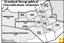
Census divisions and subdivisions
The next geographic unit down is the census division, defined as a grouping of neighbouring municipalities. Census divisions are relatively stable geographic areas, which makes it easier to follow trends over time. In Quebec, for example, the SGC code 2449 stands for the census division of Drummond in Quebec. The code is 3506 for the census division of Ottawa.
 A census division's designation may correspond to a county, a regional
district or a regional municipality. In Nova
Scotia, for example, the SGC code for Yarmouth
Municipal District is 1202004. However, in Newfoundland and Labrador and
in the three Prairie provinces,
there are no named counties or districts. So, in those provinces,
census divisions are assigned numbers (e.g., Division no. 1, 2, 3
and so on).
A census division's designation may correspond to a county, a regional
district or a regional municipality. In Nova
Scotia, for example, the SGC code for Yarmouth
Municipal District is 1202004. However, in Newfoundland and Labrador and
in the three Prairie provinces,
there are no named counties or districts. So, in those provinces,
census divisions are assigned numbers (e.g., Division no. 1, 2, 3
and so on).
The smallest geographic area in the Standard Geographical Classification is the census subdivision. Generally, a census subdivision is a single municipality or its equivalent, such as an Indian reserve. In 2001, there were 5,600 census subdivisions in Canada.
Census subdivisions can change, however, due to municipal restructuring. For example, the City of Ottawa amalgamated what were 11 census subdivisions (Kanata, Nepean, Vanier, Gloucester and seven others) into a single census subdivision. Each census subdivision is assigned a three-digit code in the classification-for example, 057 for Drummondville, Quebec, and 008 for the amalgamated Ottawa.
Putting that all together, these create a unique seven-digit identifier for every geographic location across the country. Completing the above examples, that gives an SGC identifier of 2449057 for the municipality of Drummondville, Quebec and 3506008 for the city of Ottawa, Ontario.
Roads and boundaries
Geographers also look at Canada from the perspective of the web of roads that link the provinces and territories. To facilitate this, Statistics Canada's geographers created the road network files. These provide information on major features, including roads, provincial and territorial boundaries, ocean shorelines and lakes, as well as information on attributes such as street names and address ranges.
Statistics Canada's geographers also employ cartographic boundary files. They created these to support spatial analysis and thematic mapping of data from the Census of Population. The cartographic boundary files include the boundaries of standard geographical areas, as well as the shorelines of Canada and of many inland lakes and rivers.
Used together, these two files yield a very detailed portrait of all parts of the country. This can be a powerful tool for geographers and other researchers.
Mapping our population
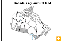
Geographers use the term ecumene-from the Greek meaning inhabited space-to refer to land where people have made their home, and to all work areas that are considered occupied.
Different types of ecumenes-industrial, environmental, forestry-have unique characteristics. For example, an agricultural ecumene shows land where people engage in some form of farming. Geographers overlay data onto agricultural ecumenes in order to create maps of any kind of agricultural activity down to small geographic areas.
A population ecumene is based on blocks that have a minimum population density of 0.4 persons per square kilometre. In cities, this usually corresponds with a city block. Geographers use population ecumenes and other geographic boundaries such as provincial/territorial and census division boundaries to create thematic maps that more accurately depict the spatial distribution of data from the Census of Population
