
Statistics Canada
www.statcan.gc.ca
Common menu bar links

Archived Content
Information identified as archived is provided for reference, research or recordkeeping purposes. It is not subject to the Government of Canada Web Standards and has not been altered or updated since it was archived. Please "contact us" to request a format other than those available.
Chart 1
Lower Mainland ecoregion, by type of land cover, circa 2000
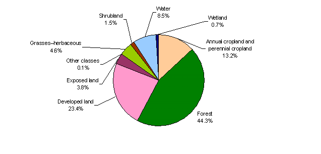
Note(s): Developed land includes built-up areas, lawns, road surfaces, industrial sites and farmsteads. Water area contains some marine water area. Exposed land refers primarily to mudflats in this ecoregion. Other refers to unclassified land types due to shadow and clouds in the satellite imagery. Land cover is based on LANDSAT satellite data from 1996 to 2003.
Source(s): Natural Resources Canada, 2009, Land Cover, Circa 2000-Vector (LCC2000-v), Earth Sciences Sector (accessed October 8, 2009).