
Chart 2.4
Annual water yield, Hudson Bay drainage area, 1971 to 2013
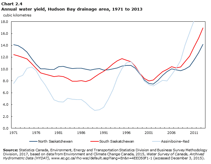
Data table for Chart 2.4
| North Saskatchewan | South Saskatchewan | Assiniboine–Red | |
|---|---|---|---|
| cubic kilometres | |||
| 1971 | 14.1 | 12.4 | 7.6 |
| 1972 | 14.0 | 12.2 | 8.6 |
| 1973 | 13.5 | 12.0 | 9.0 |
| 1974 | 12.9 | 11.7 | 10.2 |
| 1975 | 11.7 | 10.9 | 10.4 |
| 1976 | 10.8 | 10.2 | 9.8 |
| 1977 | 10.0 | 9.4 | 8.4 |
| 1978 | 10.1 | 9.2 | 7.4 |
| 1979 | 9.9 | 8.9 | 6.1 |
| 1980 | 9.9 | 8.8 | 4.8 |
| 1981 | 10.4 | 8.8 | 4.5 |
| 1982 | 10.4 | 8.7 | 4.4 |
| 1983 | 10.3 | 8.4 | 5.1 |
| 1984 | 10.1 | 8.0 | 4.9 |
| 1985 | 10.2 | 8.0 | 4.9 |
| 1986 | 10.2 | 8.0 | 4.9 |
| 1987 | 10.0 | 7.9 | 4.3 |
| 1988 | 9.8 | 8.2 | 3.5 |
| 1989 | 10.0 | 8.7 | 3.0 |
| 1990 | 10.1 | 9.2 | 3.1 |
| 1991 | 9.8 | 9.6 | 3.6 |
| 1992 | 9.9 | 10.2 | 4.9 |
| 1993 | 10.0 | 10.9 | 6.6 |
| 1994 | 10.2 | 11.4 | 8.5 |
| 1995 | 10.5 | 11.8 | 10.1 |
| 1996 | 10.6 | 11.5 | 11.1 |
| 1997 | 10.6 | 11.2 | 11.3 |
| 1998 | 10.1 | 10.4 | 10.3 |
| 1999 | 9.1 | 9.2 | 9.2 |
| 2000 | 8.2 | 8.4 | 7.9 |
| 2001 | 7.6 | 8.0 | 7.4 |
| 2002 | 7.5 | 8.2 | 7.1 |
| 2003 | 8.1 | 8.9 | 7.6 |
| 2004 | 9.0 | 9.6 | 8.1 |
| 2005 | 9.6 | 10.0 | 8.0 |
| 2006 | 10.0 | 10.4 | 9.0 |
| 2007 | 9.9 | 10.2 | 10.1 |
| 2008 | 9.7 | 10.4 | 11.4 |
| 2009 | 10.0 | 11.2 | 14.0 |
| 2010 | 10.5 | 12.2 | 16.1 |
| 2011 | 11.5 | 13.7 | 18.1 |
| 2012 | 12.8 | 15.2 | 18.4 |
| 2013 | 14.2 | 17.0 | 18.5 |
|
Source : Statistics Canada, Environment, Energy and Transportation Statistics Division and Business Survey Methodology Division, 2017, based on data from Environment and Climate Change Canada, 2015, Water Survey of Canada, Archived Hydrometric Data (HYDAT), www.ec.gc.ca/rhc-wsc/default.asp?lang=En&n=4EED50F1-1 (accessed December 3, 2015). |
|||
- Date modified: