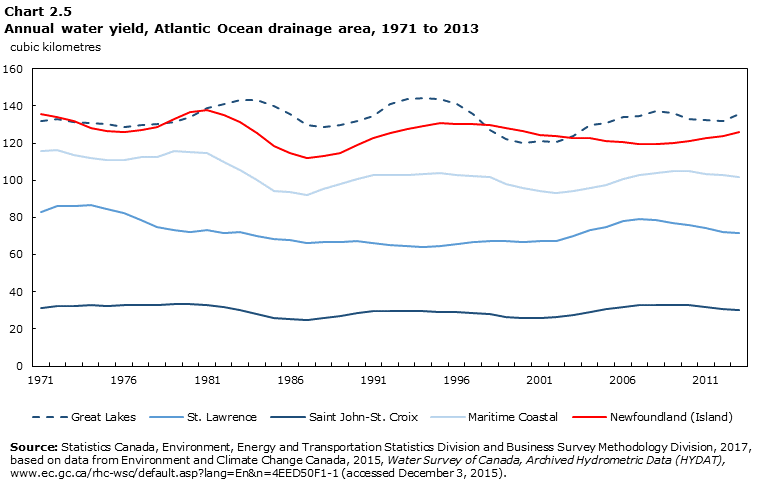
Chart 2.5 Annual water yield, Atlantic Ocean drainage area, 1971 to 2013
Chart 2.5 Annual water yield, Atlantic Ocean drainage area, 1971 to 2013
Data table for Chart 2.5
Data table for Chart 2.5
Table summary
This table displays the results of Data table for Chart 2.5 Great Lakes, St. Lawrence, Saint John–St. Croix, Maritime Coastal and Newfoundland (Island) , calculated using cubic kilometres units of measure (appearing as column headers).
Great Lakes
St. Lawrence
Saint John–St. Croix
Maritime Coastal
Newfoundland (Island)
cubic kilometres
1971
131.8
82.8
31.1
116.0
135.5
1972
132.7
86.1
32.5
116.5
134.2
1973
131.5
86.1
32.4
113.5
131.6
1974
130.8
86.7
32.6
111.9
128.2
1975
130.3
84.4
32.5
110.7
126.5
1976
128.5
82.3
32.7
111.0
126.2
1977
129.5
78.6
33.1
112.4
127.1
1978
130.2
75.0
32.6
112.3
128.7
1979
131.4
73.4
33.3
115.5
133.2
1980
133.8
72.1
33.3
115.2
136.5
1981
138.8
73.0
33.0
114.8
137.7
1982
141.0
71.8
31.5
109.5
135.1
1983
143.3
72.1
30.4
105.7
131.3
1984
143.3
70.1
28.2
100.2
125.6
1985
139.7
68.4
26.0
94.3
118.1
1986
135.7
67.7
25.4
93.5
114.4
1987
129.9
66.1
24.7
92.1
111.7
1988
128.7
66.6
25.8
95.3
113.2
1989
129.6
66.7
27.0
97.7
114.6
1990
131.7
67.1
28.4
100.6
118.7
1991
134.4
66.2
29.6
102.7
122.5
1992
141.1
65.4
29.7
103.0
125.2
1993
143.6
64.5
29.6
102.7
127.5
1994
144.3
64.1
29.5
103.3
129.0
1995
143.7
64.5
29.3
104.0
130.9
1996
141.1
65.7
28.8
102.9
130.1
1997
135.6
66.6
28.3
102.0
130.4
1998
126.8
67.3
28.0
101.9
129.6
1999
122.2
67.3
26.6
97.8
128.0
2000
120.0
67.0
26.0
95.6
126.4
2001
121.2
67.5
26.0
94.2
124.5
2002
120.7
67.4
26.2
92.9
123.6
2003
124.0
69.9
27.6
94.3
122.7
2004
129.5
73.3
29.0
95.6
122.5
2005
130.7
75.0
30.4
97.6
120.8
2006
133.9
77.9
31.7
100.6
120.5
2007
134.7
79.1
32.7
102.8
119.4
2008
137.0
78.8
32.9
103.7
119.5
2009
136.0
77.2
33.0
105.0
120.1
2010
133.0
75.9
32.7
105.0
121.2
2011
132.2
74.1
31.5
103.3
122.9
2012
131.7
72.3
30.8
102.6
124.0
2013
135.7
71.7
30.0
101.6
125.7
Source: Statistics Canada, Environment, Energy and Transportation Statistics Division and Business Survey Methodology Division, 2017, based on data from Environment and Climate Change Canada, 2015, Water Survey of Canada, Archived Hydrometric Data (HYDAT), (accessed December 3, 2015).