
Health Regions: Boundaries and Correspondence with Census Geography
Map 7 Ontario, Health Units – Southern Ontario Health Regions, 2015
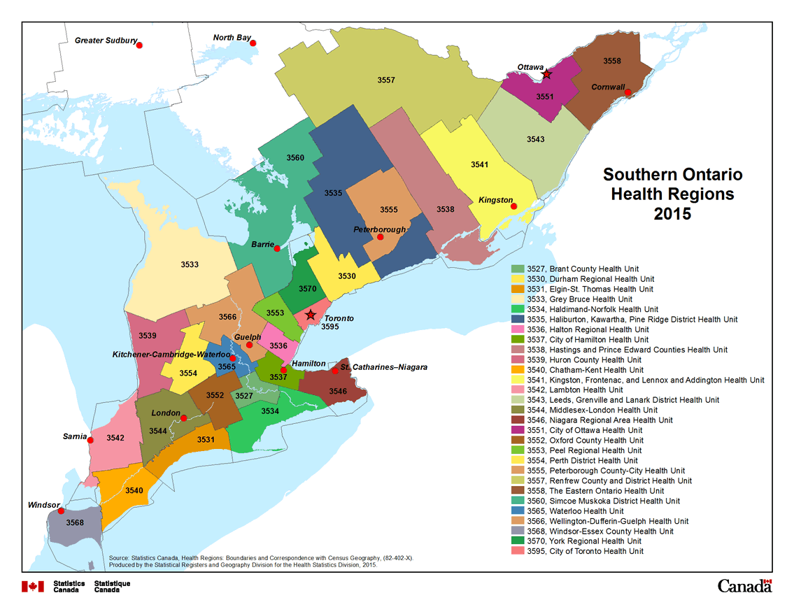
Description for Map 7
This map shows the twenty nine Public Health Units in Southern Ontario. Brant County Health Unit, code 3527, is coloured light green. Durham Regional Health Unit, code 3530, is coloured yellow. Elgin-St. Thomas Health Unit, code 3531, is coloured dark orange. Grey Bruce Health Unit, code 3533, is coloured light orange. Haldimand-Norfolk Health Unit, code 3534, is coloured green. Haliburton, Kawartha, Pine Ridge District Health Unit, code 3535, is coloured blue. Halton Regional Health Unit, code 3536, is coloured dark pink. City of Hamilton Health Unit, code 3537, is coloured green. Hastings and Prince Edward Counties Health Unit, code 3538, is coloured dark red. Huron County Health Unit, code 3539, is coloured red. Chatham-Kent Health Unit, code 3540, is coloured orange. Kingston, Frontenac and Lennox and Addington Health Unit, code 3541, is coloured yellow. Lambton Health Unit, code 3542, is coloured pink. Leeds, Grenville and Lanark District Health Unit, code 3543, is coloured green. Middlesex-London Health Unit, code 3544, is coloured dark olive green. Niagara Regional Area Health Unit, code 3546, is coloured dark brown. City of Ottawa Health Unit, code 3551, is coloured light purple. Oxford County Health Unit, code 3552, is coloured brown. Peel Region Health Unit, code 3553, is coloured light green. Perth District Health Unit, code 3554, is coloured yellow. Peterborough County-City Health Unit, code 3555, is coloured brown. Renfrew County and District Health Unit, code 3557, is coloured olive green. The Eastern Ontario Health Unit, code 3558, is coloured purple. Simcoe Muskoka District Health Unit, code 3560, is coloured green. Waterloo Health Unit, code 3565, is coloured dark blue. Wellington-Dufferin-Guelph Health Unit, codes 3566, is coloured brown. Windsor-Essex County Health Unit, code 3568, is coloured purple. York Regional Health Unit, code 3570, is coloured dark green. City of Toronto Health Unit, code 3595, is coloured red.
Public Health Units are outlined by a thin black line and labeled in black text with their four digit health region code.
Water features are displayed on the map for reference purposes. Linear water features appear on the map as a thin blue line while water bodies are shaded blue. Some cities are labeled in black text, for reference purposes.
Source: Statistics Canada, Health Regions: Boundaries and Correspondence with Census Geography, (82-402-X). Produced by the Statistical Registers and Geography Division for the Health Statistics Division, 2015.
- Date modified: