
Illustrated Glossary
Census metropolitan area (CMA) and census agglomeration (CA)
Definition
A census metropolitan area (CMA) or a census agglomeration (CA) is formed by one or more adjacent municipalities centred on a population centre (known as the core). A CMA must have a total population of at least 100,000 of which 50,000 or more must live in the core based on adjusted data from the previous Census of Population Program. A CA must have a core population of at least 10,000 also based on data from the previous Census of Population Program.
To be included in the CMA or CA, other adjacent municipalities must have a high degree of integration with the core, as measured by commuting flows derived from data on place of work from the previous Census Program.

For more information on census metropolitan area and census agglomeration, consult the Dictionary, Census of Population, 2016.
CMA and CA tutorial
Census metropolitan areas (CMAs) and census agglomerations (CAs) are considered to be large, densely populated centres made up of adjacent municipalities that are economically and socially integrated.
According to the 2016 Census, 83% of Canada's population lives within a CMA or CA. This amounts to over 29 million people. More than half of the population, a bit more than 19 million people, lives in the ten largest CMAs.
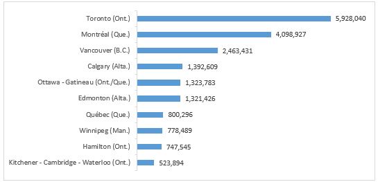
Population of Canada's ten largest census metropolitan areas, 2016 Census
Description for chart 1
Population of Canada’s ten largest census metropolitan areas, 2016 Census
This chart shows the population of the ten largest census metropolitan areas according to the 2016 Census in descending order (starting with the most populated). The population counts are: 5,928,040 in Toronto (Ont.); 4,098,927 in Montréal (Que.); 2,463,431 in Vancouver (B.C.); 1,392,609 in Calgary (Alta.); 1,323,783 in Ottawa - Gatineau (Ont./Que.); 1,321,426 in Edmonton (Alta.); 800,296 in Québec (Que.); 778,489 in Winnipeg (Man.); 747,545 in Hamilton (Ont.); and 523,894 in Kitchener - Cambridge - Waterloo (Ont.).
Source: Statistics Canada, 2016 Census of Population.
Census metropolitan areas (CMA) and census agglomerations (CAs) are formed of one or more adjacent municipalities that are centred on and have a high degree of integration with a large population centre, known as the core.
A CMA or CA is delineated using adjacent census subdivisions (CSDs) as building blocks. These CSDs, also known as municipalities, are included in the CMA or CA if they meet at least one of the following rules, which are ranked in order of priority:
- Delineation core rule
- Forward commuting flow rule
- Reverse commuting flow rule
- Spatial contiguity rule
- Historical comparability rule
- Manual adjustments
- Merging adjacent CMAs and CAs and secondary core rule
The rest of this tutorial illustrates how each of these rules is applied and how CSDs are added to a CMA or CA.
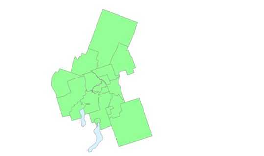
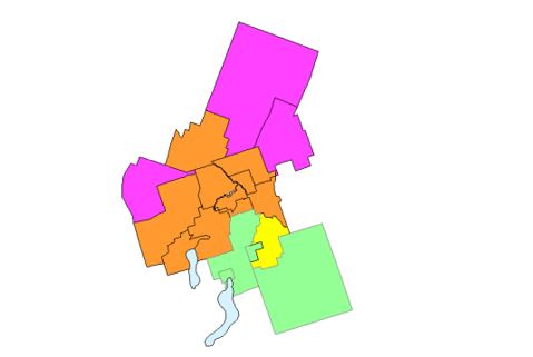
Example of census subdivisions to be evaluated in census metropolitan area and census agglomeration delineation
Description for Map
Example of census subdivisions to be evaluated in census metropolitan area and census agglomeration delineation
This map shows an example of census subdivisions to be evaluated in census metropolitan area and census agglomeration delineation.
Source: Statistics Canada, 2016 Census of Population.
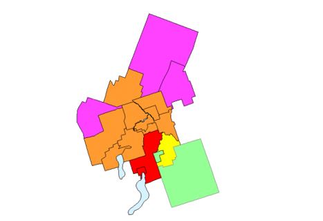
Delineation core rule
Once a population centre attains a total population of 10,000 people, it is eligible to become the core of a census agglomeration (CA). Once a population centre attains a total population of 50,000 people, then it is eligible to become the core of a census metropolitan area (CMA). The boundaries and population data for the cores that are used to delineate CMAs and CAs are taken from the previous census.
Since CMAs and CAs are based on census subdivisions (CSDs), a 'delineation core' is created from those CSDs that have at least 50% of its population living in the core. These CSDs are used for determining whether other CSDs will be included in the CMA or CA according to the next three rules.
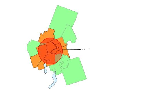
Example of census subdivisions added to a census metropolitan area or census agglomeration due to the delineation core rule
Description for Map
Example of census subdivisions added to a census metropolitan area or census agglomeration due to the delineation core rule
This map shows an example of a core and census subdivisions added to a census metropolitan area or census agglomeration due to the delineation core rule.
Source: Statistics Canada, 2016 Census of Population.
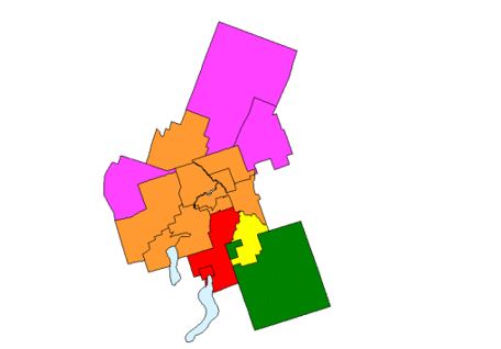
Forward commuting flow rule
Using commuting data based on the place of work question from the previous Census Program, commuting flows are calculated for workers going to the delineation core. If a surrounding census division (CSD) has a minimum of 100 commuters going into the delineation core and at least 50% of the employed labour force living in the CSD works at a fixed workplace address in the delineation core, then the CSD is included in the census metropolitan area (CMA) or census agglomeration (CA).
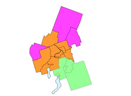
Example of census subdivisions added to a census metropolitan area or census agglomeration due to the forward commuting flow rule
Description for Map
Example of census subdivisions added to a census metropolitan area or census agglomeration due to the forward commuting flow rule
This map shows an example of census subdivisions added to a census metropolitan area or census agglomeration due to the delineation core rule and the forward commuting flow rule.
Source: Statistics Canada, 2016 Census of Population.
Reverse commuting flow rule
Commuting flows are also calculated for workers leaving the delineation core. If the delineation core has a minimum of 100 commuters going out to a surrounding census subdivision (CSD) and at least 50% of the employed labour force living in the delineation core works at a fixed workplace address in a surrounding CSD, then that CSD is included in the census metropolitan area (CMA) or census agglomeration (CA).
Example of census subdivisions added to a census metropolitan area or census agglomeration due to the reverse commuting flow rule
Description for Map
Example of census subdivisions added to a census metropolitan area or census agglomeration due to the reverse commuting flow rule
This map shows an example of census subdivisions added to a census metropolitan area or census agglomeration due to the delineation core rule, the forward commuting flow rule and the reverse commuting flow rule.
Source: Statistics Canada, 2016 Census of Population.
Spatial contiguity rule
Two situations can lead to the inclusion or exclusion of a census subdivision (CSD) in a census metropolitan area (CMA) or census agglomeration (CA) for reasons of spatial contiguity. Specifically, these are:
'CSD Outlier' – A CSD is adjacent to a CMA or CA but does not have sufficient commuting flows (either forward or reverse) to be part of the CMA or CA. However, this CSD contains another, smaller, CSD that has sufficient commuting flows to or from the delineation core to be included in the CMA or CA.
'CSD Hole' – A CSD is adjacent to a CMA or CA and has sufficient commuting flows (either forward or reverse) to be part of the CMA or CA. However, this CSD contains another, smaller, CSD that does not have sufficient commuting flows to or from the delineation core to be included in the CMA or CA.
When either of these situations arises, the CSD that is adjacent to the CMA or CA is grouped with its outliers or its holes to create a 'minimum CSD set.' The commuting flows for the minimum CSD set, as a whole, are calculated. If the commuting flows of the minimum CSD set meets either of the commuting flow rules, then all of CSDs in the set are included in the CMA or CA.
Example of census subdivisions added to a census metropolitan area or census agglomeration due to the spatial contiguity rule
Description for Map
Example of census subdivisions added to a census metropolitan area or census agglomeration due to the spatial contiguity rule
This map shows an example of census subdivisions added to a census metropolitan area or census agglomeration due to the delineation core rule, the forward commuting flow rule, the reverse commuting flow rule and the spatial contiguity rule.
Source: Statistics Canada, 2016 Census of Population.
Historical comparability rule
To maintain historical comparability for census metropolitan areas (CMAs) and larger census agglomerations (CAs) (those with census tracts in the previous census), census subdivisions (CSDs) are usually retained in the CMA or larger CA even if their commuting flow percentages falls below the commuting flow thresholds. If a CSD has had boundary changes since the last census, then the commuting flow data for that CSD are recalculated and a decision to include or exclude the CSD is made according to the previous rules.
Example of census subdivisions added to a census metropolitan area or census agglomeration due to the historical comparability rule
Description for Map
Example of census subdivisions added to a census metropolitan area or census agglomeration due to the historical comparability rule
This map shows an example of census subdivisions added to a census metropolitan area or census agglomeration due to the delineation core rule, the forward commuting flow rule, the reverse commuting flow rule, the spatial contiguity rule and the historical comparability rule.
Manual adjustments rule
A census metropolitan area (CMA) or census agglomeration (CA) represents an area that is economically and socially integrated. However, there are certain limitations to the extent by which this ideal can be met. Since the census subdivisions (CSDs) that are used as building blocks in CMA and CA delineation are administrative units, their boundaries do not always match other statistical units (i.e., population centre cores). There can be situations where the application of the above rules create undesirable outcomes, or where the rules cannot be easily applied. In these circumstances, a manual override is sometimes applied to ensure that the integrity of the program is retained.
Merging adjacent CMAs and CAs and secondary core rule
Using place of work data from the previous Census Program, commuting flows are calculated for census agglomerations (CAs) and census metropolitan areas (CMAs) that are adjacent to one another. A CA can be merged with an adjacent CMA if the total percentage commuting interchange between the CA and CMA is equal to at least 35% of the employed labour force living in the CA. The total percentage commuting interchange is the sum of the commuting flow in both directions between the CMA and the CA as a percentage of the labour force living in the CA and working at a fixed workplace address.
X 100
- Date modified: