
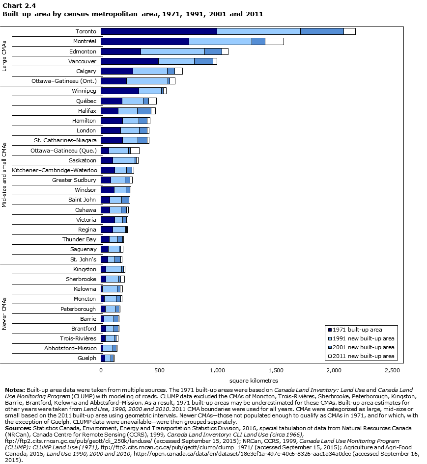
Data table for Chart 2.4
| CMA | 1971 built-up area | 1991 new built-up area | 2001 new built-up area | 2011 new built-up area |
|---|---|---|---|---|
| square kilometres | ||||
| Newer CMAs | ||||
| Guelph | 35 | 49 | 23 | 5 |
| Abbotsford–Mission | 18 | 84 | 29 | 9 |
| Trois-Rivières | 36 | 82 | 13 | 16 |
| Brantford | 44 | 66 | 40 | 5 |
| Barrie | 24 | 85 | 37 | 9 |
| Peterborough | 38 | 89 | 31 | 8 |
| Moncton | 30 | 99 | 39 | 14 |
| Kelowna | 12 | 128 | 25 | 19 |
| Sherbrooke | 44 | 108 | 18 | 33 |
| Kingston | 43 | 132 | 18 | 14 |
| Mid-size and small CMAs | ||||
| St. John's | 60 | 60 | 49 | 12 |
| Saguenay | 63 | 91 | 14 | 20 |
| Thunder Bay | 71 | 72 | 43 | 6 |
| Regina | 102 | 108 | 9 | 11 |
| Victoria | 120 | 64 | 33 | 16 |
| Oshawa | 77 | 97 | 47 | 16 |
| Saint John | 74 | 103 | 61 | 11 |
| Windsor | 113 | 101 | 36 | 8 |
| Greater Sudbury | 85 | 121 | 43 | 20 |
| Kitchener–Cambridge–Waterloo | 119 | 99 | 48 | 16 |
| Saskatoon | 103 | 188 | 13 | 16 |
| Ottawa–Gatineau (Que.) | 67 | 169 | 16 | 76 |
| St. Catharines–Niagara | 187 | 128 | 81 | 17 |
| London | 167 | 164 | 66 | 18 |
| Hamilton | 187 | 136 | 74 | 23 |
| Halifax | 148 | 166 | 115 | 39 |
| Québec | 183 | 180 | 46 | 67 |
| Winnipeg | 326 | 191 | 19 | 23 |
| Large CMAs | ||||
| Ottawa–Gatineau (Ont.) | 219 | 353 | 19 | 45 |
| Calgary | 273 | 298 | 62 | 66 |
| Vancouver | 492 | 309 | 159 | 35 |
| Edmonton | 342 | 549 | 146 | 56 |
| Montréal | 755 | 542 | 113 | 161 |
| Toronto | 995 | 719 | 369 | 102 |
|
Notes: Built-up area data were taken from multiple sources. The 1971 built-up areas were based on Canada Land Inventory: Land Use and Canada Land Use Monitoring Program (CLUMP) with modeling of roads. CLUMP data excluded the CMAs of Moncton, Trois-Rivières, Sherbrooke, Peterborough, Kingston, Barrie, Brantford, Kelowna and Abbotsford–Mission. As a result, 1971 built-up areas may be underestimated for these CMAs. Built-up area estimates for other years were taken from Land Use, 1990, 2000 and 2010. 2011 CMA boundaries were used for all years. CMAs were categorized as large, mid-size or small based on the 2011 built-up area using geometric intervals. Newer CMAs—those not populated enough to qualify as CMAs in 1971, and for which, with the exception of Guelph, CLUMP data were unavailable—were then grouped separately. Sources: Statistics Canada, Environment, Energy and Transportation Statistics Division, 2016, special tabulation of data from Natural Resources Canada (NRCan), Canada Centre for Remote Sensing (CCRS), 1999, Canada Land Inventory: CLI Land Use (circa 1966), ftp://ftp2.cits.rncan.gc.ca/pub/geott/cli_250k/landuse/ (accessed September 15, 2015); NRCan, CCRS, 1999, Canada Land Use Monitoring Program (CLUMP): CLUMP Land Use (1971), ftp://ftp2.cits.rncan.gc.ca/pub/geott/clump/clump_1971/ (accessed September 15, 2015); Agriculture and Agri-Food Canada, 2015, Land Use 1990, 2000 and 2010, http://open.canada.ca/data/en/dataset/18e3ef1a-497c-40c6-8326-aac1a34a0dec (accessed September 16, 2015). |
||||
- Date modified: