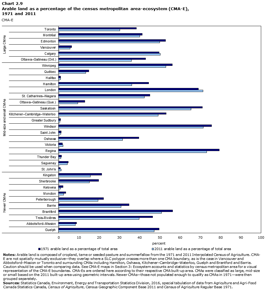
Data table for Chart 2.9
| CMA | 1971 arable land as a percentage of total area | 2011 arable land as a percentage of total area |
|---|---|---|
| percent | ||
| Newer CMAs | ||
| Guelph | 50 | 47 |
| Abbotsford–Mission | 9 | 8 |
| Trois-Rivières | 46 | 40 |
| Brantford | 56 | 51 |
| Barrie | 35 | 31 |
| Peterborough | 22 | 19 |
| Moncton | 4 | 3 |
| Kelowna | 2 | 1 |
| Sherbrooke | 20 | 15 |
| Kingston | 21 | 16 |
| Mid-size and small CMAs | ||
| St. John's | 1 | 1 |
| Saguenay | 5 | 4 |
| Thunder Bay | 1 | 1 |
| Regina | 79 | 73 |
| Victoria | 2 | 2 |
| Oshawa | 40 | 32 |
| Saint John | 1 | 1 |
| Windsor | 76 | 72 |
| Greater Sudbury | 1 | 1 |
| Kitchener–Cambridge–Waterloo | 53 | 49 |
| Saskatoon | 71 | 65 |
| Ottawa–Gatineau (Que.) | 13 | 9 |
| St. Catharines–Niagara | 45 | 42 |
| London | 69 | 71 |
| Hamilton | 45 | 36 |
| Halifax | 1 | 1 |
| Québec | 15 | 13 |
| Winnipeg | 56 | 53 |
| Large CMAs | ||
| Ottawa–Gatineau (Ont.) | 43 | 36 |
| Calgary | 50 | 50 |
| Vancouver | 6 | 6 |
| Edmonton | 53 | 50 |
| Montréal | 41 | 40 |
| Toronto | 38 | 30 |
|
Notes: Arable land is composed of cropland, tame or seeded pasture and summerfallow from the 1971 and 2011 Interpolated Census of Agriculture. CMA-E are not spatially mutually exclusive—they overlap where a SLC polygon crosses more than one CMA boundary, as is the case in Vancouver and Abbotsford–Mission or Toronto and surrounding CMAs including Hamilton, Oshawa, Kitchener–Cambridge–Waterloo, Guelph and Brantford and Barrie. Caution should be used when comparing data. See CMA-E maps in Section 3: Ecosystem accounts and statistics by census metropolitan area for a visual representation of the CMA-E boundaries. CMA-Es are ordered here according to their respective CMA built-up area. CMAs were classified as large, mid-size or small based on the 2011 built-up area using geometric intervals. Newer CMAs—those not populated enough to qualify as CMAs in 1971—were then grouped separately. Sources: Statistics Canada, Environment, Energy and Transportation Statistics Division, 2016, special tabulation of data from Agriculture and Agri-Food Canada Statistics Canada, Census of Agriculture, Census Geographic Component Base 2011 and Census of Agriculture Regular Base 1971. |
||
- Date modified: