
CMA and CA: Detailed definition

Archived Content
Information identified as archived is provided for reference, research or recordkeeping purposes. It is not subject to the Government of Canada Web Standards and has not been altered or updated since it was archived. Please "contact us" to request a format other than those available.
A census metropolitan area (CMA) or a census agglomeration (CA) is formed by one or more adjacent municipalities centred on a population centre (known as the core). A CMA must have a total population of at least 100,000 of which 50,000 or more must live in the core. A CA must have a core population of at least 10,000. To be included in the CMA or CA, other adjacent municipalities must have a high degree of integration with the core, as measured by commuting flows derived from previous census place of work data.
If the population of the core of a CA declines below 10,000, the CA is retired. However, once an area becomes a CMA, it is retained as a CMA even if its total population declines below 100,000 or the population of its core falls below 50,000. Small population centres with a population count of less than 10,000 are called fringe. All areas inside the CMA or CA that are not population centres are rural areas.
When a CA has a core of at least 50,000, it is subdivided into census tracts. Census tracts are maintained for the CA even if the population of the core subsequently falls below 50,000. All CMAs are subdivided into census tracts.
Census years
2011, 2006, 2001, 1996, 1991, 1986, 1981, 1976, 1971, 1966, 1961, 1956, 1951, 1941
Remarks
The terms 'core,' 'fringe' and 'rural area' replace the terms 'urban core,' 'urban fringe' and 'rural fringe' for the 2011 Census.
Cores
A census metropolitan area (CMA) or a census agglomeration (CA) can have more than one core. The core of a CMA must have a population of at least 50,000 and the core of a CA must have a population of at least 10,000. In all other cases where a CMA or a CA has more than one core, the additional cores are called secondary cores. When a CA is merged with a CMA, the core of the former CA also becomes a secondary core of the CMA. If the population of a fringe population centre exceeds 10,000, it becomes a secondary core of the CMA or CA in which it exists. See Merging adjacent CMAs and CAs (delineation rule 7).
Delineation rules for CMAs and CAs
A CMA or CA is delineated using adjacent municipalities (census subdivisions) as building blocks. These census subdivisions (CSDs) are included in the CMA or CA if they meet at least one of the following rules. The rules are ranked in order of priority. A CSD obeying the rules for two or more CMAs or CAs is included in the one for which it has the highest ranked rule. If the CSD meets rules that have the same rank, the decision is based on the population or the number of commuters involved. A CMA or CA is delineated to ensure spatial contiguity.
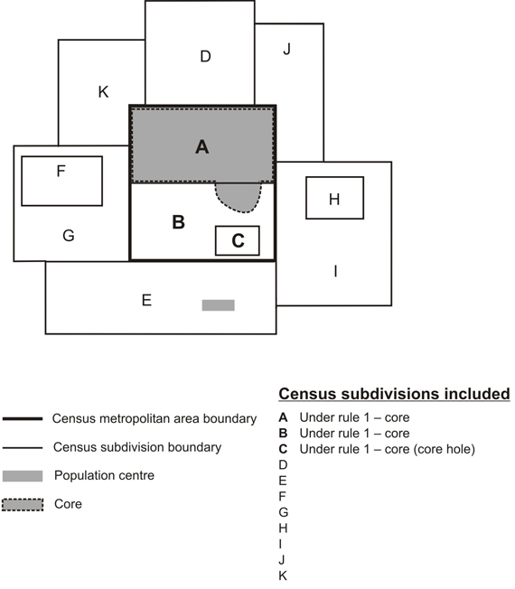
1. Core rule: The CSD falls completely or partly inside the core.
A core hole is a CSD enclosed by a CSD that is at least partly within the core and must be included to maintain spatial contiguity. In Figure 6, CSDs A, B and C are included in the CMA or CA because of the core rule. CSD C is a core hole.
Figure 6
Core rule
Source: Statistics Canada, 2011 Census of Population.
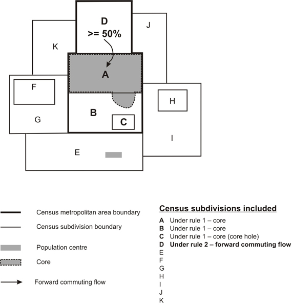
2. Forward commuting flow rule: Given a minimum of 100 commuters, at least 50% of the employed labour force living in the CSD works in the delineation core (see following note), as determined from commuting data based on the place of work question in the previous census.
Note: For CMA and CA delineation purposes, a delineation core is created respecting CSD limits. For a CSD to be included in the primary or the secondary delineation core, at least 75% of a CSD's population must reside within the core. In Figure 7, CSD A is part of the delineation core since its entire population resides within the core. CSD B would also be part of the delineation core if at least 75% of its population resides within the core. For this example, we have assumed that less than 75% of the population of CSD B resides within the core; therefore, CSD B and its enclosed hole, CSD C, are not considered to be part of the delineation core.
Figure 7
Forward commuting flow rule
Source: Statistics Canada, 2011 Census of Population.
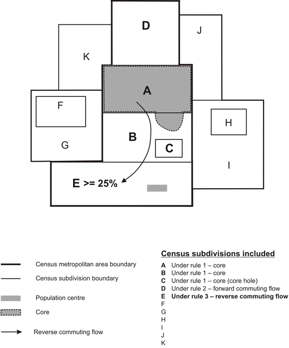
3. Reverse commuting flow rule: Given a minimum of 100 commuters, at least 25% of the employed labour force working in the CSD lives in the delineation core as determined from commuting data based on the place of work question in the previous census. In Figure 8, at least 25% of the employed labour force working in CSD E lives in CSD A (see Note for rule 2).
Figure 8
Reverse commuting flow rule
Source: Statistics Canada, 2011 Census of Population.
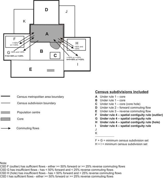
4. Spatial contiguity rule: CSDs that do not meet a commuting flow threshold may be included in a CMA or CA, and CSDs that do meet a commuting flow threshold may be excluded from a CMA or CA.
Two situations can lead to inclusion or exclusion of a CSD in a CMA or CA for reasons of spatial contiguity. Specifically these are:
Outlier — A CSD (F in Figure 9) with sufficient commuting flows (either forward or reverse) is enclosed by a CSD (G in Figure 9) with insufficient commuting flows, but which is adjacent to the CMA or CA. When this situation arises, the CSDs within and including the enclosing CSD are grouped to create a minimum CSD set (F + G). The total commuting flows for the minimum CSD set are then considered for inclusion in the CMA or CA. If the minimum CSD set has sufficient commuting flows (either forward or reverse), then all of its CSDs are included in the CMA or CA.
Hole — A CSD (H in Figure 9) with insufficient commuting flows (either forward or reverse) is enclosed by a CSD (I in Figure 9) with sufficient commuting flows, and which is adjacent to the CMA or CA. When this situation arises, the CSDs within and including the enclosing CSD are grouped to create a minimum CSD set (H + I). The total commuting flows for the minimum CSD set are then considered for inclusion in the CMA or CA. If the minimum CSD set has sufficient commuting flows (either forward or reverse), then all of its CSDs are included in the CMA or CA.
Figure 9
Spatial contiguity rule
Source: Statistics Canada, 2011 Census of Population.
5. Historical comparability rule: To maintain historical comparability for CMAs and larger CAs (those with census tracts in the previous census), CSDs are retained in the CMA or CA even if their commuting flow percentages fall below the commuting flow thresholds (rules 2 and 3). See Figure 10.
Figure 10
Historical comparability rule
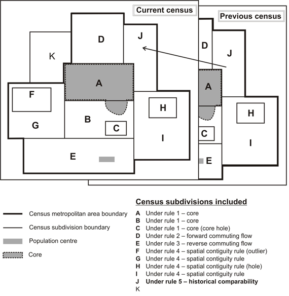
Source: Statistics Canada, 2011 Census of Population.
An exception to the historical comparability rule is made in cases where CSDs have undergone changes to their boundaries, such as annexations. To determine whether to keep or exclude a CSD, place of work data are retabulated for the CSD with boundary changes, and a decision to include or exclude the CSD is made according to the previous rules.
6. Manual adjustments: A CMA or CA represents an area that is economically and socially integrated. However, there are certain limitations to the extent by which this ideal can be met. Since the CSDs that are used as building blocks in CMA and CA delineation are administrative units, their boundaries are not always the most suitable with respect to CMA and CA delineation. There are always situations where the application of the above rules creates undesirable outcomes, or where the rules cannot be easily applied. In these circumstances, a manual override is sometimes applied to ensure that the integrity of the program is retained. For example, in Miramichi CA (New Brunswick), the CSD of Red Bank 4, IRI, which is in two parts, is included to maintain spatial contiguity.
7. Merging adjacentCMAs and CAs: A CA adjacent to a CMA can be merged with the CMA if the total percentage commuting interchange between the CA and CMA is equal to at least 35% of the employed labour force living in the CA, based on place of work data from the previous census. The total percentage commuting interchange is the sum of the commuting flow in both directions between the CMA and the CA as a percentage of the labour force living in the CA (i.e., resident employed labour force).
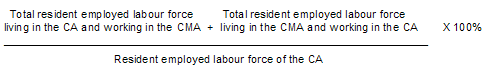
If more than one CA is adjacent to the same CMA, each CA is assessed separately with the CMA. Several CAs may be merged with one CMA. If the total percentage commuting interchange is less than 35%, the CMA and CA are not merged. After a CA is merged with a CMA, the core of the former CA is called the secondary core of the CMA. See Figure 11.
Figure 11
Example of a merged census metropolitan area and census agglomeration
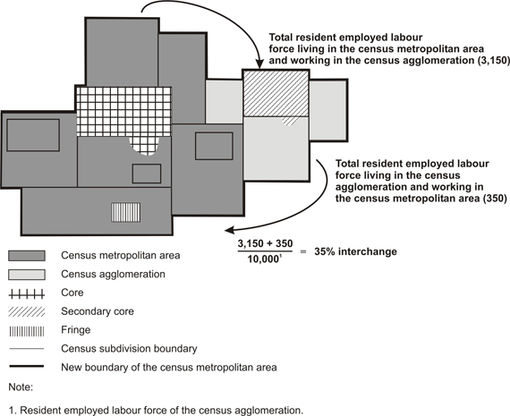
Source: Statistics Canada, 2011 Census of Population.
Naming convention for CMAs and CAs
Prior to May 25, 2009, the convention for the naming of a CMA or CA was based on the name of the principal population centre or largest city at the time the CMA or CA was first formed. This standard had been used since the 1971 Census. Through the years, the CMA and CA names have remained stable. The most important changes resulted from name changes to the census subdivisions (resulting from municipal dissolutions, incorporations and name changes).
Guidelines for CMA name change requests
The key revision to the convention is the establishment of 'Guidelines for CMA name change requests' as published in Preliminary 2011 Census Metropolitan and Census Agglomeration Delineation(Catalogue no. 92F0138M). Below are the guidelines for requesting a change:
- CMA names can consist of up to three legislated municipal names of eligible census subdivisions (CSDs) that are components of the CMA. However, the number of name elements in any new CMA name request is limited to five. If any of the eligible CSD names are already hyphenated or compound, the number of CSD names will be limited to two or one if the number of name elements exceeds five.
- The eligible municipal names include the historic central municipality name and the two component CSDs with the largest population, and having a population of at least 10,000, according to the last census.
- The ordering of the municipal names within the CMA name is determined by the historic (central) municipality and the population size of the eligible CSDs. The first component of the CMA name is always the historic (central) CSD even if its census population count is less than the other eligible component CSDs. This ensures that CMA names retain a measure of stability for better longitudinal recognition. The second and third place name order is determined by population size. The component CSD with the higher census population count at the time of the name change assumes the second position and the next largest component CSD, the third position.
- In order for a requested CMA name change to be implemented, there must be explicit consensus among all eligible component municipalities on a proposed new name and a formal request, in accordance with these guidelines, must be sent to the Director of the Geography Division at Statistics Canada by June 1 of the year prior to the census. The CMA name change will be implemented in the revision of the Standard Geographical Classification related to the census under consideration.
- Statistics Canada will continue to change CMA names whenever the legislated name of a municipality changes. Any other request for a name change will only be considered within the context of these guidelines.
CMA/CA coding structure
Each CMA and CA is assigned a three-digit code that identifies it uniquely in Canada. The first digit is the same as the second digit of the province code in which the CMA or CA is located. If a CMA or CA spans a provincial boundary, then the province code assigned represents the province with the greater proportion of core population. Codes for CAs in Yukon and the Northwest Territories begin with the same digit as for those CMAs or CAs located in British Columbia. There are currently no CMAs or CAs in Nunavut.
| CMA /CA code | CMA /CA name |
|---|---|
| 001 | St. John's CMA (N.L.) |
| 215 | Truro CA (N.S.) |
| 462 | Montréal CMA (Que.) |
| 995 | Yellowknife CA (N.W.T.) |
If data for provincial parts are required, it is recommended that the two-digit province/territory (PR) code precede the CMA/CA code for those CMAs/CAs that cross provincial boundaries. For example:
| PR- CMA /CA code | CMA /CA name |
|---|---|
| 24 505 | Ottawa - Gatineau CMA (Quebec part) |
| 35 505 | Ottawa - Gatineau CMA (Ontario part) |
| 47 840 |
Lloydminster CA (Saskatchewan part) |
| 48 840 |
Lloydminster CA (Alberta part) |
Table 1 in the Introduction shows the number of census metropolitan areas and census agglomerations by province and territory.
Changes to the number of CMAs and CAs for the 2011 Census
Two CMAs from the previous census had their names changed: Abbotsford became Abbotsford-Mission (B.C.) and Kitchener became Kitchener-Cambridge-Waterloo (Ont.).
Five new CAs were created: Steinbach (Man.), High River (Alta.), Strathmore (Alta.), Sylvan Lake (Alta.) and Lacombe (Alta.).
The CAs of La Tuque (Que.) and Kitimat (B.C.) were retired because the population of their cores dropped below 10,000 in 2006.
Data quality
CMAs and CAs are statistically comparable because they are delineated in the same way across Canada. They differ from other areas such as trading or marketing areas, or regional planning areas designated by regional authorities for planning and other purposes, and should be used with caution for non-statistical purposes.
The CSD limits used in CMA and CA delineation are those in effect on January 1, 2011 (the geographic reference date for the 2011 Census) and received by Statistics Canada before March 1, 2011. In addition, CMA and CA delineation uses commuting data based on the place of work question asked in the previous census.
Refer to the related definitions of census subdivision (CSD); core, fringe and rural area; population centre (POPCTR) and to the geography working paper Preliminary 2011 Census Metropolitan Area and Census Agglomeration Delineation(Catalogue no. 92F0138MWE2009002).
Changes prior to the current census
2006
- For 2006, CAs were no longer required to have an urban core population of 100,000 to be promoted to the status of a CMA. Instead, CAs assumed the status of a CMA if they had attained a total population of at least 100,000 of which 50,000 or more lived in the urban core.
- Prior to the 2011 Census, CMA and CA delineation used commuting data based on the place of work question asked in the decennial census. The 2006 CMAs and CAs are based on the population and place of work data from the 2001 Census while the 2001 and 1996 CMAs and CAs are based on population and place of work data from the 1991 Census.
2001
- For 2001, CAs were required to have an urban core population of at least 100,000 to be changed to the status of a CMA.
- For 2001, consolidated CMAs were no longer defined for dissemination purposes. As a result, primary CMAs and primary CAs were also not defined. However, the consolidation rule was retained and incorporated into the CMA delineation methodology. There was no substantive change to the methodology for defining CMAs and no change to the limits of CMAs resulting from this rule change.
- Prior to 2001, adjacent CMAs and CAs that had sufficient commuting interchange (35% or more) and were merged were identified by the terms 'primary census metropolitan area (PCMA)' and 'primary census agglomeration (PCA).' The terms 'consolidated census metropolitan area (CCMA)' and 'consolidated census agglomeration (CCA)' described the sum of the component CMAs and CAs. Census data were disseminated for these areas. These terms were not used for the standard dissemination program for 2001.
- Six of 27 CMAs were affected significantly as a result of municipal restructuring: Halifax (N.S.), Ottawa – Hull (Ont./Que.), Kingston (Ont.), Greater Sudbury (Ont.), London (Ont.) and Windsor (Ont.).
1996
- Two changes to CMA/CA delineation rules were implemented to preserve data comparability over time. CMAs could be consolidated with CAs, but they could not be consolidated with other CMAs. A primary census agglomeration (PCA) could not be retired from a consolidated CMA or CA (with census tracts at the previous census) even if its total commuting interchange percentage dropped below the consolidation threshold of 35%. Exceptions to this rule could occur due to changes in the physical structure of the urban areas used to determine the urban cores.
- Minimum sets of CSDs were used instead of the census consolidated subdivisions (CCSs) for evaluation in the spatial contiguity rule. Refer to the spatial contiguity rule (rule 4).
1986
- Introduction of the consolidated and primary CMA and CA concept.
- The forward commuting threshold was raised from 40% to 50% to control for differences in processing of the place of work data between 1971 and 1981.
- Introduction of the minimum of 100 commuters for forward and reverse commuting for both CMAs and CAs. Single CSD (component) CAs were permitted.
1981
- Commuting data based on the place of work question of the previous decennial census were used for the first time to delineate CAs. For both CMAs and CAs, the forward commuting threshold was 40% and the reverse commuting threshold was 25%.
- The minimum urbanized core population for CAs was raised from 2,000 to 10,000.
- CAs were eligible for census tracts if they had a CSD with a population of at least 50,000 at the time of the previous census. Single CSD (component) CAs could be created for subdivision into census tracts.
1976
- Commuting data based on the place of work question of the previous decennial census were used for the first time to delineate CMAs. The forward commuting threshold was 40% and the reverse commuting threshold was 25% for the CMAs.
- For CAs, see 1971.
1971
- CMAs were defined as main labour market areas, but were delineated according to alternate criteria based on the labour force composition, population growth rate and accessibility. At this time, the CMA of Saint John, N.B. was 'grandfathered.'
- CAs were comprised of at least two adjacent municipal entities. These entities had to be at least partly urban and belong to an urbanized core having a population of at least 2,000. The urbanized core included a largest city and a remainder, each with a population of at least 1,000, and had a population density of at least 1,000 per square mile (386 people per square kilometre).
1966
- See 1961.
1961
- CMAs were delineated around cities with a population of at least 50,000, if the population density and labour force composition criteria were met, and the total CMA population was at least 100,000.
- CAs were called major urban areas; see 1951.
1956
- See 1951.
1951
- The term 'census metropolitan area' appeared for the first time. This term designated cities of over 50,000 having fringe municipalities in close geographic, economic and social relations, the whole constituting a unit of over 100,000.
- The concept of 'major urban areas,' the forerunners to CAs, was introduced. The term designated urban areas in which the largest city had a population of at least 25,000 and fewer than 50,000.
1941
- Data were published for 'greater cities,' i.e., those cities which have well-defined satellite communities in close economic relationship to them.
- Date modified: