
Standard Geographical Classification (SGC)

Archived Content
Information identified as archived is provided for reference, research or recordkeeping purposes. It is not subject to the Government of Canada Web Standards and has not been altered or updated since it was archived. Please "contact us" to request a format other than those available.
Detailed definition
The Standard Geographical Classification (SGC) 2011 is Statistics Canada's main classification of geographic areas in Canada. It is designed to classify statistical information by geographic areas. The classification consists of four levels: geographical regions of Canada, provinces and territories, census divisions (such as counties and regional municipalities) and census subdivisions (such as municipalities). The four geographic levels are hierarchically related; a seven-digit code is used to show this relationship.
The 2011 version of the SGC includes three classification variants:
- Statistical Area Classification – Variant of SGC 2011
This classifies census subdivisions by census metropolitan areas (CMAs), census agglomerations (CAs) and census metropolitan influenced zones (MIZ) in the areas outside CMAs and CAs. - Statistical Area Classification by Province and Territory – Variant of SGC 2011
This classifies census subdivisions by census metropolitan areas (CMAs), census agglomerations (CAs) and census metropolitan influenced zones (MIZ) in the areas outside CMAs and CAs. In this classification variant, these categories are further classified by provinces and territories. - Economic Regions – Variant of SGC 2011
This classifies census subdivisions into census divisions and economic regions.
Censuses
2011, 2006, 2001, 1996, 1991, 1986, 1981, 1976, 1971, 1966, 1961
Remarks
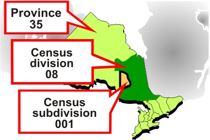
Census subdivisions (CSDs) aggregate to census divisions (CDs), which aggregate to province or territory which, in turn, aggregate to geographical regions of Canada (Figure 2).
Figure 2
Standard geographical classification (SGC) hierarchy
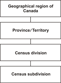
Source: Statistics Canada, 2011 Census of Population.
The hierarchical relationship is reflected in the seven-digit SGC code. For example:
| PR-CD-CSD code | Description | |
|---|---|---|
| 12 06 008 | Province 12: | Nova Scotia |
| CD 06: | Lunenburg | |
| CSD 008: | Mahone Bay | |
| 35 06 008 | Province 35: | Ontario |
| CD 06: | Ottawa | |
| CSD 008: | Ottawa | |
Changes to the Standard Geographical Classification for the 2011 Census
This version introduces structural changes to the classification. It introduces a new level to the standard: geographical regions of Canada. The geographical regions of Canada are:
- Atlantic
- Quebec
- Ontario
- Prairies
- British Columbia
- Territories
They represent aggregations of provinces and territories.
The structural change also introduces the new classification variants 'Statistical Area Classification – Variant of SGC 2011' and 'Statistical Area Classification by Province and Territory – Variant of SGC 2011.' These include the census metropolitan areas and census agglomerations and classify the areas of Canada outside CMAs and CAs by census metropolitan influenced zones. Standard terminology has been established for the census metropolitan influenced zones.
The economic regions are now formally recognized as a part of the SGC and are included in the classification variant: 'Economic Regions – Variant of SGC 2011.'
Refer to the related definitions of census division (CD); census metropolitan area (CMA) and census agglomerations (CA); census metropolitan influenced zones (MIZ); census subdivision (CSD); economic region (ER) and province or territory. The Standard Geographical Classification is presented in the 2011 Standard Geographical Classification (SGC), Volumes I and II (Catalogue nos. 12-571-X and 12-572-X).
Changes prior to the current census
In 1976 and 1971, both SGC and census codes were used to disseminate census data.
In 1966 and 1961, only census codes were used to disseminate census data.
- Date modified: