
Chart 3.17
Land cover and land use, Hamilton census metropolitan area-ecosystem (CMA-E), 1971, 1991, 2001 and 2011
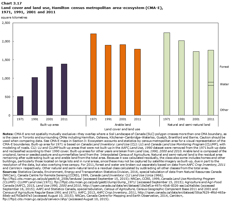
Description for Chart 3.17
| Land cover and land use | Square kilometers | ||
|---|---|---|---|
| 1971 | Built-up | 512 | |
| Arable | 2,201 | ||
| Natural and semi-natural | 2,232 | ||
| 1991 | Built-up | 1,027 | |
| Arable | 1,897 | ||
| Natural and semi-natural | 2,021 | ||
| 2001 | Built-up | 1,310 | |
| Arable | 1,909 | ||
| Natural and semi-natural | 1,725 | ||
| 2011 | Built-up | 1,389 | |
| Arable | 1,791 | ||
| Natural and semi-natural | Forest | 866 | |
| Water | 91 | ||
| Other | 808 | ||
|
Notes: CMA-E are not spatially mutually exclusive—they overlap where a Soil Landscape of Canada (SLC) polygon crosses more than one CMA boundary, as is the case in Toronto and surrounding CMAs including Hamilton, Oshawa, Kitchener–Cambridge–Waterloo, Guelph, Brantford and Barrie. Caution should be used when comparing data. See CMA-E maps in Section 3: Ecosystem accounts and statistics by census metropolitan area for a visual representation of the CMA-E boundaries. Built-up area for 1971 is based on Canada Land Inventory: Land Use (CLI: LU) and Canada Land Use Monitoring Program (CLUMP), with modeling of roads. CLI: LU and CLUMP built-up areas that were not built-up in the AAFC Land Use, 1990 dataset were removed from the 1971 built-up data and reclassified according to their 1990 cover. Built-up areas for other years are taken from Land Use, 1990, 2000 and 2010. Arable land is composed of the cropland, tame or seeded pasture and summerfallow land from the Interpolated Census of Agriculture. Natural and semi-natural land is the residual area remaining after subtracting built-up and arable land from the total area. Because it was calculated residually, the class also includes some homes and other buildings, particularly those located on large lots and in rural areas, since these may not be captured by satellite imagery as built-up, due in part to the resolution of the data, but also overlying tree canopy. For 2011, forest and water are broken out separately based on data from AAFC Crop Inventory, 2011 and CanVec+ respectively. Other natural and semi-natural land is a residual class calculated by subtracting all other classes from the total area. Sources: Statistics Canada, Environment, Energy and Transportation Statistics Division, 2016, special tabulation of data from Natural Resources Canada (NRCan), Canada Centre for Remote Sensing (CCRS), 1999, Canada Land Inventory: CLI Land Use (circa 1966), ftp://ftp2.cits.rncan.gc.ca/pub/geott/cli_250k/landuse/ (accessed September 15, 2015); NRCan, CCRS, 1999, Canada Land Use Monitoring Program (CLUMP): CLUMP Land Use (1971), ftp://ftp2.cits.rncan.gc.ca/pub/geott/clump/clump_1971/ (accessed September 15, 2015); Agriculture and Agri-Food Canada (AAFC), 2015, Land Use 1990, 2000 and 2010, http://open.canada.ca/data/en/dataset/18e3ef1a-497c-40c6-8326-aac1a34a0dec (accessed September 16, 2015); AAFC and Statistics Canada, special tabulation, Census of Agriculture, Census Geographic Component Base 2011 and 2001 and Census of Agriculture Regular Base 1991 and 1971; AAFC, 2013, AAFC Crop Inventory, 2011, http://open.canada.ca/data/en/dataset/58ca7629-4f6d-465a-88eb-ad7fd3a847e3 (accessed August 10, 2015); NRCan, Canada Centre for Mapping and Earth Observation, 2014, CanVec+, ftp://ftp2.cits.rncan.gc.ca/pub/canvec+/shp/ (accessed August 10, 2015). |
|||
- Date modified: