
Map 3.3.11
Land use and water yield for the South Saskatchewan drainage region
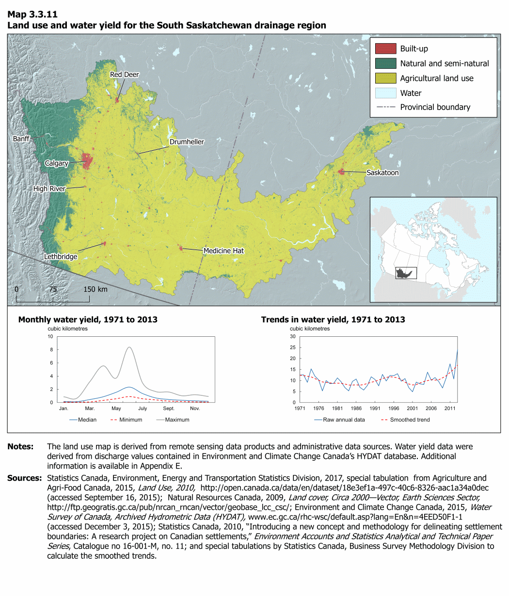
Description for Map 3.3.11
The title of this map is “Land use and water yield for the South Saskatchewan drainage region.” It includes three components: a map on land use and two charts on water yield.
The map has two main components—a large map that shows land use for the drainage region and an inset that locates the region within Canada. The drainage region extends from the Rocky Mountain foothills in southern Alberta into Saskatchewan and includes Calgary, Red Deer and Saskatoon.
On the map dark red represents built-up, dark green represents natural and semi-natural, yellow represents agricultural land use and pale blue represents water. In 2011, the region was dominated by agricultural land use. Natural and semi-natural area was concentrated in the western part of the region. The largest built-up area occurred around Calgary with smaller patches around Saskatoon and other centres.
Provincial boundaries are indicated with a dashed grey line, while international boundaries are indicated by a thick grey line and thin dashed black line. Drainage regions are indicated by a black line. The locations and names of some of the larger population centres within the drainage region are included on the map. Land areas outside the drainage region are coloured medium grey while areas outside Canada are light grey.
Below the map, two charts provide information on water yield for the drainage region. The titles of the charts are “Monthly water yield, 1971 to 2013” and “Trends in water yield, 1971 to 2013.”
A line representing the smoothed trend of the raw annual data points is also included on the chart for Trends in water yield, 1971 to 2013.
Notes: The land use map is derived from remote sensing data products and administrative data sources. Water yield data were derived from discharge values contained in Environment and Climate Change Canada’s HYDAT database. Additional information is available in Appendix E.
Sources: Statistics Canada, Environment, Energy and Transportation Statistics Division, 2017, special tabulation from Agriculture and Agri-Food Canada, 2015, Land Use, 2010, (accessed September 16, 2015); Natural Resources Canada, 2009, Land cover, Circa 2000 - Vector, Earth Sciences Sector, Environment and Climate Change Canada , 2015, Water Survey of Canada, Archived Hydrometric Data Online, (accessed December 3, 2015); Statistics Canada, 2010, “Introducing a new concept and methodology for delineating settlement boundaries: A research project on Canadian settlements,” Environment Accounts and Statistics Analytical and Technical Paper Series, Catalogue no. 16-001-M, no. 11; and special tabulations by Statistics Canada, Business Survey Methodology Division to calculate the smoothed trends.
| Jan. | Feb. | Mar. | Apr. | May | June | July | Aug. | Sept. | Oct. | Nov. | Dec. | |
|---|---|---|---|---|---|---|---|---|---|---|---|---|
| cubic kilometres | ||||||||||||
| Median | 0.16 | 0.14 | 0.47 | 0.88 | 1.57 | 2.34 | 1.37 | 0.71 | 0.47 | 0.35 | 0.27 | 0.20 |
| Minimum | 0.06 | 0.05 | 0.09 | 0.33 | 0.58 | 0.91 | 0.58 | 0.41 | 0.22 | 0.16 | 0.10 | 0.06 |
| Maximum | 0.88 | 0.67 | 3.21 | 5.56 | 3.72 | 8.40 | 2.96 | 1.67 | 1.60 | 1.03 | 1.19 | 0.93 |
| Year | Water yield |
|---|---|
| cubic kilometres | |
| 1971 | 12.5 |
| 1972 | 12.6 |
| 1973 | 9.2 |
| 1974 | 15.3 |
| 1975 | 12.0 |
| 1976 | 10.3 |
| 1977 | 5.3 |
| 1978 | 10.0 |
| 1979 | 8.6 |
| 1980 | 8.7 |
| 1981 | 11.2 |
| 1982 | 9.4 |
| 1983 | 6.8 |
| 1984 | 5.3 |
| 1985 | 9.6 |
| 1986 | 10.7 |
| 1987 | 6.9 |
| 1988 | 5.7 |
| 1989 | 7.8 |
| 1990 | 11.7 |
| 1991 | 10.5 |
| 1992 | 7.6 |
| 1993 | 12.8 |
| 1994 | 9.8 |
| 1995 | 12.3 |
| 1996 | 12.2 |
| 1997 | 13.1 |
| 1998 | 9.7 |
| 1999 | 10.9 |
| 2000 | 6.8 |
| 2001 | 4.9 |
| 2002 | 9.3 |
| 2003 | 8.5 |
| 2004 | 8.2 |
| 2005 | 13.8 |
| 2006 | 10.1 |
| 2007 | 11.4 |
| 2008 | 9.5 |
| 2009 | 6.6 |
| 2010 | 11.3 |
| 2011 | 17.6 |
| 2012 | 10.7 |
| 2013 | 24.0 |
- Date modified: