
Census consolidated subdivision (CCS)

Archived Content
Information identified as archived is provided for reference, research or recordkeeping purposes. It is not subject to the Government of Canada Web Standards and has not been altered or updated since it was archived. Please "contact us" to request a format other than those available.
Detailed definition
A census consolidated subdivision (CCS) is a group of adjacent census subdivisions. Generally, the smaller, more densely-populated census subdivisions (towns, villages, etc.) are combined with the surrounding, larger, more rural census subdivision, in order to create a geographic level between the census subdivision and the census division.
Censuses
2011, 2006, 2001, 1996, 1991, 1986, 1981, 1976, 1971, 1966
Remarks
Census consolidated subdivisions are defined within census divisions (CDs) according to the following criteria:
- A census subdivision (CSD) with a land area greater than 25 square kilometres can form a CCS of its own. Census subdivisions having a land area smaller than 25 square kilometres are usually grouped with a larger census subdivision.
- A census subdivision with a land area greater than 25 square kilometres and surrounded on more than half its perimeter by another census subdivision is usually included as part of the CCS formed by the surrounding census subdivision.
- A census subdivision with a population greater than 100,000 according to the last census usually forms a CCS on its own.
- The census consolidated subdivision's name usually coincides with its largest census subdivision component in terms of land area.
The geographic code assigned to each census consolidated subdivision is the seven-digit Standard Geographical Classification (SGC) code of one of its component CSDs, usually the one with the largest land area (Figure 5 shows a hypothetical example). This assignment process also makes the CCS code unique across Canada. For example:
| PR-CD-CCS code | CCS name |
|---|---|
| 24 32 045 | Plessisville (Que.) |
| 35 32 045 | Blandford-Blenheim (Ont.) |
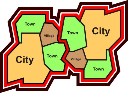
Figure 5
Example of census consolidated subdivisions (CCSs) and census subdivisions (CSDs)

Source: Statistics Canada, 2011 Census of Population.
Table 1 in the Introduction shows the number of census consolidated subdivisions by province and territory.
CCSs are used primarily for disseminating Census of Agriculture data. They form the building block for census agricultural regions in Saskatchewan. In all other provinces, census agricultural regions are made up of groups of census divisions.
CCSs are relatively stable geographic units because they have infrequent boundary changes and therefore can be useful for longitudinal analysis.
Refer to the related definitions of census division (CD) and census subdivision (CSD).
Changes prior to the current census
For 1991, significant boundary changes were made to CCSs in Quebec when census divisions were restructured to recognize the municipalités régionales de comté.
For 1976, the term 'census consolidated subdivision' was introduced. Prior to 1976, CCSs were referred to by the term 'reference code.'
- Date modified: