
Ecumene

Archived Content
Information identified as archived is provided for reference, research or recordkeeping purposes. It is not subject to the Government of Canada Web Standards and has not been altered or updated since it was archived. Please "contact us" to request a format other than those available.
Detailed definition
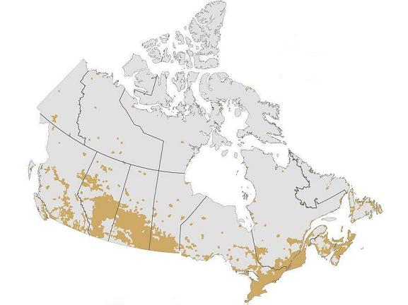
Ecumene is a term used by geographers to mean inhabited land. It generally refers to land where people have made their permanent home, and to all work areas that are considered occupied and used for agricultural or any other economic purpose. Thus, there can be various types of ecumenes, each having its own unique characteristics (population ecumene, agricultural ecumene, industrial ecumene, etc.).
Censuses
2011, 2006, 2001, 1996, 1991, 1986, 1981, 1976 (national population ecumene)
2011, 2006, 2001, 1996, 1991, 1986, 1981, 1976 (national agricultural ecumene)
1986 (urban population ecumene for 12 census metropolitan areas)
Remarks
Ecumene is derived from the Greek root oixos meaning inhabited and nenon meaning space.
Statistics Canada delineates the population and agricultural ecumenes as follows:
-
The national population ecumene includes dissemination blocks with a minimum population density. To ensure visibility for small-scale thematic mapping, the detailed ecumene limits are manually generalized and small, discontiguous ecumene pockets are aggregated.
-
The national agricultural ecumene includes all dissemination areas with 'significant' agricultural activity. Agricultural indicators, such as the ratio of agricultural land on census farms relative to total land area, and total economic value of agricultural production, are used. Regional variations are also taken into account. The ecumene is generalized for small-scale mapping.
It is recommended that the ecumene concept be used for dot and choropleth maps. If an ecumene is not applied to dot maps, the requisite number of dots may be randomly spread over entire unit areas. This approach defeats the main attributes of dot mapping (i.e., showing correct location, extent and density of the dot symbols). One of the inherent limitations of choropleth maps is that the statistical distribution is assumed to be homogeneous or uniformly spread over each unit area, and is consequently represented by tones or colours covering the entire unit. Thus, an ecumene renders a more accurate depiction of the spatial distribution of data.
Refer to related definitions of cartographic boundary files (CBFs); datum; dissemination area (DA); dissemination block (DB); Spatial Data Infrastructure (SDI) and thematic map.
- Date modified: