Table of contents
1 Introduction
2 Confidentiality
3 Geography
4 Dictionary format and contents
5 LAD register
6 Programming tips
Sample LAD program
7 Design of LAD variable acronyms
8 LAD variable definitions
Additional personal exemptions
Adoption Expenses
Age
Age exemption amount
Age imputation flag
Alimony deduction (claimed)
Alimony or support deductions (paid)
Alimony or support income
Amount for children under age 18 – federal amounts transferred from a spouse or common law partner
Amount of self-employed income from T4 slips for a shareholder
Amount of the provincial children's arts tax credit, as claimed by the client
Annuity income from RRSP
Area size code
Attendant care expenses
Bankruptcy code
Basic personal amount
Benefit for disabled children
British Columbia mining exploration tax credit
British Columbia Harmonized sales tax-credit
British Columbia Low income climate action tax credit
British Columbia seniors' home renovation tax credit
British Columbia shipbuilding and ship repair industry tax credit (employers)
Business income, gross
Business income, net
Business investment loss
Canada employment amount
Canadian Forces personnel and police deduction
Capital gain held in reserve from the disposition of capital property
Capital gains deferral from qualifying dispositions of eligible small business corporation shares
Capital gains exemption, calculated
Capital gains/losses, net taxable
Capital gains or losses, net
Capital gain (or loss) of qualified small business corporation shares
Capital gain or loss on prior year reserves
Caregiver amount
Carrying charges and interest expenses
Census Division (CD)
Census Division - unique
Census metropolitan area (CMA)
Census Metropolitan Area - unique
Census Sub-division (CSD)
Census Sub-division - unique
Census tract (CT)
Census Tract - unique
Charitable donations calculated
Child care expense deduction
Children Fitness amount
Children fitness amount (as claimed by the client)
Children, total number by specific year of age
Child Tax benefit
Child Tax credit
Children, number of children under age 18
Children, ages of the seven youngest
Children, total number in family
Children amount deduction
Children deduction, amount transferred to a spouse or common-law partner
Children's Art Amount
Clergy residence deduction
Commission income from T4 slips
Commission income, gross
Commission income, net
CPP/QPP benefits
CPP or QPP deduction or tax credit on self-employment earnings
CPP overpayment
CPP/QPP total contributions payable from self-employment
CPP/QPP contributions through employment T4
CPP/QPP contributions through employment
CPP/QPP disability benefits included in income
CPP earnings code
CPP receipt – number of months
Credit for interest paid on a student loan
Date of departure of emigrant
Death, year of
Deduction for provincial parental insurance plan premiums on self-employment income
Deductions transferred from spouse
Disability amount for a dependent other than spouse
Disability amount for self
Disability deduction transferred
Dividends
Donations and gifts tax credit, federal non-refundable
Donations
Education amount & tuition fees transferred from a child
Educational deduction for full-time student
Educational deduction (full-time) - calculated
Educational deduction for part-time student
Education deduction transferred from a dependant
Elected split pension amount
Elected split pension amount deduction
Elected split pension - Federal Tax amount calculated
Employment Income
Employment income from T4 slips, total
Employment insurance assistance as part of a workforce re-entry initiative
Employment insurance benefits
Employment insurance benefits repaid deduction
Employment insurance overpayment for the provincial parental insurance plan – net
Employment insurance premiums from T4 slips
Employment insurance premiums on self-employment and other eligible earnings
Employment insurance repayment
Entry Date of Immigrant
Equivalent to spouse amount
Expenses, other allowable
Exploration and developments, expenses
Family Allowance received
Family Allowance repayment, calculated
Family Allowance, Quebec
Family benefits
Family benefits, British Columbia
Family caregiver – net income of eligible dependant
Family caregiver – number of dependants
Family caregiver tax credit for a dependant (claimed)
Family caregiver tax credit for a spouse or common-law partner (claimed)
Family flag
Family flag for same sex couple
Family identification number
Family type
Family size
Farming and fishing income eligible for the capital gains deduction from the disposition of eligible capital property
Farming income, gross
Farming income, net
Federal dividend tax credit
Final balance payable/refundable
Fishing income gross
Fishing income, net
Foreign business income taxes paid
Gifts – Cultural and ecological
Gross medical expenses
GST and FST credits
GST rebate for employees and self-employed
Harmonized sales tax credit
Home Buyers Amount
Home Buyer's Plan repayment
Home Buyer's Plan shortfall amount
Home Buyer's Plan withdrawal
Home Relocation Loan deduction, employee
Home Renovation Expenses
Immigrant/emigrant code
Immigrant category
Immigrant's country of birth
Immigrant's country of citizenship at landing
Immigrant's country of last permanent residence
Immigrant's intended occupation
Immigrant's intended place of destination
Immigrant's level of education at landing.
Immigrant's marital status at landing
Immigrant's native language (or mother tongue)
Immigrant's official languages ability indicator
Immigrant's special program code
Immigrant's years of schooling at landing.
Income after tax, total (ISD definition)
Income after tax, including capital gains.
Income before tax, total (CRA definition)
Income before tax, total (ISD definition)
Income before tax, total (ISD definition), including capital gains
Indian exempt employment income
Individual, description of
Interest and investment income
Investment tax credit
Labour-sponsored funds tax credit
LAD identification number
Landing year
Language, English or French
Limited partnership income, net
Limited partnership losses of other years.
Low income status (ISD total income after tax)
Low income status (ISD total income before tax)
Main principal industry sub-sector of employers
Manitoba advance tuition fee income tax rebate
Manitoba fertility treatment tax credit
Marital status
Market income.
Market income, including capital gains
Master categorization of immigrant categories
Medical expenses, calculated
Minimum tax carryover
Moving expenses deduction
Net capital gain or loss from bonds, debentures, promissory notes, and other similar properties
Net capital gain or loss from other mortgage foreclosures and conditional sales repossessions
Net capital gain or loss on mortgage foreclosures and conditional sales repossessions of qualified farm property and qualified fishing property
Net capital gain or loss on prior year reserves
Net capital losses of other years
Net eligible dividends
Net federal supplements
Net Foreign business income received
Net income
Newfoundland Volunteer Firefighter tax credit
Non-capital losses of other years
Non-refundable tax credit, calculated
Non-refundable tax credits
Non-Taxable income
Non-taxable portion of capital gains on gifts of certain capital
Northern Ontario Energy Credit
Northern Ontario Energy Credit, Tax filer applied for the
Northern resident's deduction calculated.
Northwest Territories, Cost of living tax credit
Nova Scotia affordable living tax credit
Nova Scotia poverty reduction tax credit
Nova Scotia volunteer firefighters and ground search and rescue tax credit
Nova Scotia volunteer firefighters and ground search and rescue tax Credit (as calculated by CRA)
Number of children for whom the taxfiler claimed the family caregiver amount
Number of members with a SIN
Nunavut, Cost of living tax credit
Nunavut, Volunteer firefighter tax credit
Nunavut, Volunteer firefighter tax credit (as calculated by CRA)
Old Age Security pension
Old Age repayment, calculated
Old Age Security Guaranteed Income Supplement Recipient Indicator
Ontario Amount paid for your accommodation in a public long term care home
Ontario apprenticeship training tax credit
Ontario Children's Activity Tax Credit
Ontario Co-operative education tax credit
Ontario Energy and Property Tax Credit – Energy Component of the
Ontario Energy and Property Tax Credit, Tax filer applied for the
Ontario guaranteed annual income system
Ontario healthy home renovation tax credit
Ontario Home energy costs paid for your principal residence on a reserve
Ontario Sales Tax Transition Benefit
Ontario Sales Tax Credit
Other Deductions
Other deductions from net income
Other employment income
Other income
Other than eligible dividends, net
Pension adjustment
Pension and superannuation income
Pension income deduction
Political contributions, gross federal
Political contributions, provincial
Political contribution tax credit, federal
Political contribution tax credit, provincial
Postal code
Postal delivery mode
PPIP included in employment insurance premiums through employment
Presence of individual in LAD Flag
Prince Edward Island volunteer firefighter tax credit
Principal industry sub-sector of employers, number of
Professional income, gross
Professional income, net
Province or territory (SGC)Province assistance benefits
Province of residence
Province of residence, if different than the mailing address
Provincial home buyers tax credit
Provincial Parental Insurance Plan, Premium paid
Provincial parental insurance plan premiums payable on employment
Provincial Parental Insurance Plan Premiums Payable on Self-Employment Income
Provincial refundable tax credits
Provincial seniors' benefit
Public transit passes amount
QPP contribution flag
QPP contributions through employment – T4.
QPP total contributions payable from self-employment in Quebec
Quebec abatement
Refund of investment tax credit
Refundable medical expense supplement
Registered disability savings plan
Registered pension plan contribution
Regular employment insurance benefits payable
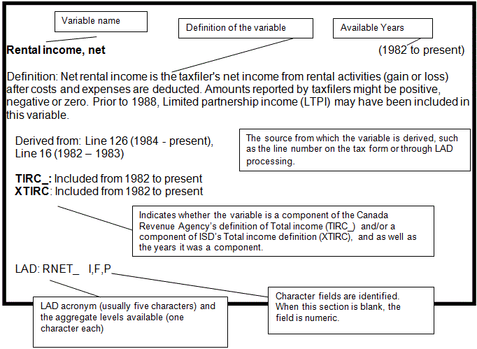
Rental income, gross
Rental income, net
RRSP, earned income for (calculated)
RRSP, transfers to a
RRSP contributions
RRSP deduction limit, current year
RRSP deduction limit amount, next year
RRSP income
RRSP income for persons aged 65 and over
RRSP spousal contributions
Saskatchewan graduate tuition refundSaskatchewan Low Income Tax Credit
Saskatchewan Pension Plan contributions
Secondary principal industry sub-sector of employers
Self-employment income exemption for Status Indians flag
Self-employment income flag
Self-employment income for an Indian registered, or eligible to be registered, under the Indian Act
Self-employment, net income
Sex of individual
Social assistance income
Social benefits repayment
Social insurance number, change code
Spouse or Common-law partner amount
Spouse's universal child care benefit repayment
Standard industrial classification code
Stock option benefit deduction
T4 slips issued to individual, number of
Tax, net federal calculated
Tax, net provincial calculated
Tax deducted for OAS required clawback
Taxable amount of dividends (eligible and other than eligible) from taxable Canadian corporations
Taxable Income
Tax paid by instalments
Taxation province
Tax-Free Savings Account Fair Market Value.
Tax-Free Savings Account Total Contributions
Tax-Free Savings Account Total Withdrawals.
Tax return type code, filer
Total amount of spousal and child support payments paid
Total amount of spousal and child support payments received
Total deductions for calculation of net income
Total EI insurable earnings on Self-employment income
Total income tax deducted
Total proceeds of disposition of mortgage foreclosures and conditional sales repossessions of qualified farm property and qualified fishing property
Total proceeds of disposition of qualified small business corporation shares - Capital Gains (or Losses)
Transfer payment income
Trust tax credit
Tuition and education transferred by spouse
Tuition and education amounts, total calculated amount claimed as a credit
Tuition fees for self
Union, professional and other dues
Universal Child Care Benefit
Universal child care benefit designated to dependent child
Universal Child Care Benefit Repayment
Volunteer Firefighter tax credit (Federal credit)
Workers' compensation payments
Working Income Tax Benefit
Working income tax benefit advance payments
Yukon, First Nations tax credit claimed
Yukon Federal refundable First Nations abatement
9 Selected income variable counts and amounts for individuals, 2011 to 2012
10 Correspondence with the IMDB variables
11 Definition of total income variables
Table 1 Components of XTIRC, 2012
Table 2 Components of MKINC, 1982 to 2012
Table 3 History of components of XTIRC
Table 4 Differences between TIRC and XTIRC, 1982 to 2012
Table 4 Part 2 Variables to be added or removed from TIRC to create XTIRC
Table 5 Definition of XTIRC, 1982 to 2012
Table 6 Definition of MKINC, 1982 to 2012
Introduction
The Longitudinal Administrative Databank (LAD) is a subset of the T1 Family File (T1FF). The T1FF is a yearly cross-sectional file of all taxfilers and their families. Census families are created from information provided annually to the Canada Revenue Agency in personal income tax returns. Both legal and common law spouses are attached by the spousal Social Insurance Number (SIN) listed on the tax form, or by matching based on name, address, age, sex, and marital status. Children are identified through a similar algorithm and supplementary files. Prior to 1993, non-filing children were identified from information on their parents' tax form. Information from the Family Allowance Program was used to assist in the identification of children. Since 1993, information from the Child Tax Benefit Program has been used for this purpose.
The LAD is a random, 20% sample of the T1FF. Selection for LAD is based on an individual's SIN. There is no age restriction, but people without a SIN can only be included in the family component. Once a person is selected for the LAD, the individual remains in the sample and is picked up each year from the T1FF if he or she appears on the T1 that year. Individuals selected for the LAD are linked across years by a unique LAD identification number (LIN__I) generated from the SIN, to create a longitudinal profile of each individual. The LAD is augmented up each year with a sample of new taxfilers so that it consists of approximately 20% of taxfilers for every year. The 20% sample has increased from 3,227,485 people in 1982 to 5,332,700 in 2012 (an increase of 65%). This increase reflects increases in the Canadian population and increases in the incidence of tax filing as a result of the introduction of the Federal sales tax credit in 1986 and the Goods and Services Tax credit in 1989.
The LAD is organized into four levels of aggregation, namely the individual, spouse/parent, family, and child(ren) levels. The databank contains information on demographics, income, and other taxation data at the different levels of aggregation from 1982-2012, with new years of data being added as the information becomes available. Changes in tax legislation and in the design of the T1 form itself have resulted in some variables not being available for all years as well as some minor definitional changes from one year to the next.
The LAD is currently linked with the Longitudinal Immigration Database (IMDB) containing immigration records from 1980 to 2011. This linkage has been approved by the Statistics Canada Policy Committee.
The LAD has been designed to serve as a research tool from which custom tabulations can be prepared. This dictionary, in turn, has been created to assist researchers in identifying the type of information that is available from the LAD. It identifies and defines the LAD variables including historical changes.
Confidentiality
Statistics Canada protects the confidentiality of individuals' tax data. Only aggregated information that conforms to the confidentiality provision of the Statistics Act is released. The LAD resides within Statistics Canada and all retrievals are done on site. Only a small staff within the Income Statistics Division (ISD) can access such data directly. This means that users must specify their data requirements to these persons who then carry out the retrieval. More information on the confidentiality procedures can be obtained from Client Services.
Geography
Data from the LAD are available for various levels of geography including Canada, provinces/territories, and regions (such as Census Division (CD), Census Metropolitan Area /Census Agglomeration (CMA/CA), Census sub-division (CSD) and Census Tracts (CT), etc.). Many other levels of geography are not included on the main LAD database, for example Economic Region (ER) and Federal Electoral District (FED); however these are available in the LAD using the Postal Code Conversion File.
Dictionary format and contents
Outlined below is a brief description of the next nine sections of the LAD Dictionary.
The LAD register (Section 5) is a file that is used in conjunction with the yearly LAD files. The Register outlines the years that an individual is on the LAD and provides information on the taxfiler's sex, year of birth, and year of death. This section provides a brief description of this file and describes how it can be used to enhance LAD data analysis.
The Programming tips section (Section 6) provides information on writing programs for LAD retrievals. This information will assist those individuals who want to better access data from LAD files using the effective programming structure.
The Design of LAD variable acronyms (Section 7) is a description of the variable acronym structure. It provides insight into how to interpret the variable acronyms and information on the aggregation levels.
The LAD variable definitions (Section 8), alphabetically lists each variable by name. In addition, the following information is provided for each variable:
- The years the variable is available on the LAD. The term ‘present' denotes the most recent year of LAD data available.
- The definition of the variable.
- The source of the variable such as the line number on the tax form or through LAD processing.
- Where relevant, the availability and historical continuity of the variable in relation to Canada Revenue Agency's definition of total income (TIRC_) and to ISD's definition of Total Income (XTIRC). This information is provided only for those variables that are a component of either definition of total income. For additional information on the income variables see Section 10, Definition of total income variables.
- The acronym used to identify each variable and the aggregation levels available.
The Variable counts and amounts for individuals, outlines, for many variables, at the individual aggregate level, the count of individuals and the dollar amounts reported for the two most recent years of LAD data. Persons included in these counts and amounts are those who have been selected into the LAD sample.
The Correspondence with the IMDB variables presents the variables from the Longitudinal Immigration Database (IMDB) that are linked with the LAD.
The Definition of total income variables (Section 10) identifies and defines total income variables and highlights historical changes. Also provided are tables that outline and compare the variables that comprise market income and the Canada Revenue Agency's (CRA) and Income Statistics Division's (ISD) definitions of total income.
The tables outlined in this section are the following:
- Table 1 Components of XTIRC for the most recent year of LAD data.
- Table 2 Components of MKINC, 1982 to the most recent year of LAD data.
- Table 3 History of components of XTIRC
- Table 4 Differences between TIRC and XTIRC, 1982 to the most recent year of LAD data
- Table 5 Definition of XTIRC, 1982 to the most recent year of LAD data
- Table 6 Definition of MKINC, 1982 to the most recent year of LAD data
Finally, How to obtain more information on the inside cover provides information on how to contact us by telephone, mail, fax, or e-mail from across Canada.
LAD register
The LAD register is a companion data file to the yearly LAD files. It contains a selected number of variables for all individuals who are present at any time in the LAD. These variables have characteristics that should remain constant over time and thus may not be identified in a particular yearly file. A new LAD register is created every year with the addition of a new LAD yearly file from taxfiler information provided from living or deceased taxfilers and imputed individuals. Thus, the current register contains the most up-to-date information on individuals present in the LAD. On rare occasions, new information on individuals may differ from that on the existing file. In these instances, current information supersedes information in the existing LAD register.
The LAD register is a quick reference tool that can provide basic data without accessing the yearly files. For example, information such as the number of individuals in the LAD by age and sex in a given year can be tabulated directly from the register. Further, the LAD register can be employed in conjunction with the yearly files. In particular, it is recommended that the age of an individual be calculated from the register's information on the year of birth rather than relying on the age information in the yearly files in order to ensure that it is consistent across years.
Following is a list of the variables that can be found on the register:
LIN__I: This is a numeric variable uniquely identifying each individual in LAD
SXCO_I: This is a character variable identifying the sex of the individual.
‘F': females ‘M': males
‘ ': when blank, the sex of the individual has not been identified
YOB__I: This is a four digit numeric field identifying the year of birth of the individual (e.g. 1947). The age of the individual in any given year can be calculated by subtracting the year of birth from that given year (e.g. in 2000, an individual born in 1965 would be 2000-1965 = 35 at the end of the 2000 calendar year).
YOD__I: This is a four digit numeric field identifying the year of death of the individual. For individuals who have not passed away, this field is missing.
FLAG_I (plus the relevant LAD year, for example FLAG_I1982, etc). These are character variables that identify the years in which an individual is present in the LAD files. They take the following values:
‘1': the individual has filed in that year
‘2': information for the individual has been imputed for that year
‘ ': (blank): the individual is not present in that year.
TTNFLI: Flag to indicate whether or not an individual has a temporary SIN, where:
‘Y' (Yes) = Temporary SIN;
‘N' (No) = No temporary SIN.
Temporary SINs are issued to temporary workers, non-residents, students with student visas, etc. In these cases, a SIN may change from one year to the next if, for instance, the individual becomes a permanent resident or a Canadian citizen. In the LAD files, LIN__I generated from the original SIN is maintained in order to ensure that information for an individual can be linked across years.
IMMFLI: Flag to indicate whether or not an individual is a Canadian immigrant, who landed between 1980 and the present, where:
‘Y' (Yes) = Immigrant;
‘N' (No) = Not an immigrant.
LNDYR I: This is a four digit numeric field identifying the landing year in which the immigrant landed (e.g. 1990). For individuals who are not an immigrant, this field is missing.
WGT__I : This is an individual noise weighting variable used with all procedures invoked in the SAS programs on the LAD 10% sample. It is a noise variable used to protect confidentiality. This variable is also found in the yearly files.
WGT2_I: As the previous variable this is an individual noise variable used to protect confidentiality. This weighting variable is used with all procedures invoked by the SAS programs with the LAD 20% sample. This variable is found in the yearly files as well.
Programming tips
This section provides programming information for individuals who want to have a better understanding of the programming structure used to access data from the LAD files. Please note that individuals may undertake their own programming, however, only a small staff within Statistics Canada can carry out these retrievals. Access to the LAD files is restricted to protect the confidentiality of an individual's tax data and any data that are made available will be screened through a set of rules designed to prevent disclosure.
There are two types of LAD files— the yearly LAD data files and the LAD register (for more details on the LAD register, refer to section 5, LAD register). LAD variables are identified with a variable name that consists of three parts: 1) the acronym name, 2) the aggregate level, and 3) the year (the four-digit year extension exists in most, but not all cases). Observations in the LAD files are sorted by a variable, named lin__i (note that there is no year extension for this variable), which enables users to maintain a link across years.
Data access is undertaken with SAS programming language. The next page contains a sample SAS program designed to access LAD data. The library assignments on the first three lines are the locations for the input files (first two lines) and the output files (the third line). The input files are in SAS format and can therefore be accessed with a SET or MERGE statement. This 20 % sample based program is aimed at retrieving the number of Social Assistance (SA) recipients in Ontario that did not have any earnings appearing on their T4 slips,according to sex and year (in this case, 2000 to 2002). It is generally recommended that programs use the variables available in the register rather than the yearly files because the register information contains the most recent data. For example, the following program uses sxco_i, a variable found in the register, rather than sxco_i&yr, the variable found in the yearly LAD files. The flag_i&yr variables in the register are useful to identify individuals who have filed in a given year. In this program, only individuals who have filed every year from 2000 to 2002 are selected. At the end of the program, four tables are created from the output data file. Note that for confidentiality purposes, the weight variables wgt__i (with the LAD 10% sample) or wgt2_i (with the LAD 20% sample) must be used whenever a SAS procedure such as FREQ or LOGISTIC is invoked.
When programming in SAS, it is important to keep in mind the distinction between missing values and zeros in numeric fields. With SAS, most mathematical operations undertaken with missing values will return missing values. In LAD, in years that an individual is present, numeric variables not relevant to that individual have a value of zero. For example, if a non-family person has filed in 2000, then the value for RRSPSI2000 (contributions to a spouse's RRSP) should be zero. If that individual has not filed in 2000, then the value will be missing. Thus, as a safety precaution, it is suggested that all numeric variables to be used in mathematical expressions be initialized to zero if missing, before using them.
Sample LAD program
* Sample SAS program using the LAD;
libname source1 '/LADdata/data1'; * first 10% sample ;
libname source2 '/LADdata/data2'; * second 10% sample ;
libname Out '/LADuser/xxxx/data'; * user's directory ;
* This sample program's objective is to use the 20% LAD to retrieve the number of Social Assistance (SA) recipients in Ontario that did not have any earnings appearing on their T4 slips, according to sex and year (in this case, 2000 to 2002). Data for provinces and earnings are from the yearly LAD files whereas the sex variable is from the 2002LAD register (the most recent). ;
* The first step is to create a datafile containing all the information that we need to produce our tables. This datafile will be called SAOnt and will be saved in the 'out' directory. The Longitudinal Identifier Number (LIN__I) is used to merge the annual LAD datasets. ;
data out.SAOnt;
merge
source1.lad2000(where=(prco_i2000 = 5) keep=lin__i prco_i2000 saspyi2000 t4e__i2000)
source2.lad2000(where=(prco_i2000 = 5) keep=lin__i prco_i2000 saspyi2000 t4e__i2000)
source1.lad2001(where=(prco_i2001 = 5) keep=lin__i prco_i2001 saspyi2001 t4e__i2001)
source2.lad2001(where=(prco_i2001 = 5) keep=lin__i prco_i2001 saspyi2001 t4e__i2001)
source1.lad2002(where=(prco_i2002 = 5) keep=lin__i prco_i2002 saspyi2002 t4e__i2002)
source2.lad2002(where=(prco_i2002 = 5) keep=lin__i prco_i2002 saspyi2002 t4e__i2002)
source1.reg2002(keep=lin__i sxco_i flag_i2000-flag_i2002 wgt2_i)
source2. reg2002(keep=lin__i sxco_i flag_i2000-flag_i2002 wgt2_i);
by lin__i ;
If flag_i2000=1 and flag_i2001=1 and flag_i2002=1; *person must be taxfiler in all 3 years;
* We create a flag variable that identifies the SA receipients for each year. The result is three variables, flag_sa2000, flag_sa2001 and flag_sa2002, taking a value of either 1 or 0.
If (t4e__i2000=0 and saspyi2000>0) then flag_sa2000 = 1 ;
else flag_sa2000 = 0 ;
if (t4e__i2001=0 and saspyi2001>0) then flag_sa2001 = 1 ;
else flag_sa2001 = 0 ;
if (t4e__i2002=0 and saspyi2002>0)then flag_sa2002 = 1 ;
else flag_sa2002 = 0 ;
run ;
* The SAS 'freq' procedure is used to produce our tables. We would also need to make sure that confidentiality guidelines standards are respected. ;proc freq data = out.SAOnt;
tables sxco_i*flag_sa2000*flag_sa2001*flag_sa2002 /missing;
weight wgt2_i ;
run ;
* End of the sample program ;
Design of LAD variable acronyms
Most LAD variables have a ten-character acronym. Each acronym consists of three parts, namely the variable name (five characters), the aggregate level (one character), and the calendar year (four characters), e.g. XTIRCI2000.
The variable name is the principal component of the acronym. The characters identify the type of information provided by the variable (see section 8 "LAD Variable Definitions").
The one-character aggregate level character provides information on individuals of the census family according to the designated level of aggregation. There are four possibilities, namely ‘I', ‘P', ‘F', and ‘K' representing individual, parents, family and children (kids) respectively. The family types outlined in these aggregate levels refer to the status of the family at the end of the tax year. Following are details about each of these aggregate levels:
I (Individual):
A variable with this aggregate level provides information only for the individual (to be selected into the sample, an individual must have a SIN). In most cases this information is taken from the individual's own tax form, though some individuals who have not filed are imputed from a spouse's tax form or from information from an earlier year, and therefore have imputed information (since 1993 imputed children can be selected into the sample).
P (Parents/spouse):
This aggregate level indicates that the variable contains data for the parent(s) in the census family for couple families or for single-parent families. For couple families, Parents/spouse represents the partner's individual characteristics. The income is the sum of the income of the two parents / spouses. The partner's income in particular year is the difference between this summed income and the individual income eg. XTIRCP2000 – XTIRCI2000. In the case of lone-parent families or persons not in census families, Parents/spouse is the parent's or person not in census families' individual information.
Because deceased people are attached to families, there are some cases in which variables at the ‘P' aggregate level contain information for more than two individuals. If an individual who is a person not in a census family as of December 31st of the year had a spouse who died during the year, the parent aggregate level may contain information for both the individual and his or her spouse. This can occur if an individual's spouse has recently passed away and the individual has since remarried. In such cases, the ‘P' variables can contain information for three people, the individual, the individual's living spouse, and the individual's deceased spouse. There are a few variables with a ‘P' aggregate level that provide information on only one person in the census family regardless of the family composition. These variables include age, gross business / commission / farming / fishing / professional income, immigrant/emigrant code, English/French language, landing year and year of death.
F (Family):
This aggregate level indicates that the information in the variable is an aggregate of all members in the individual's census family, including the individual himself/herself. Once again, note that deceased individuals are attached to families; therefore this variable can contain information aggregated over more individuals than just the census family. The exceptions are LIMATIyyyy and LIMXTIyyyy, which are the low income status variables using ISD's after-tax income and total income definitions, respectively. These two variables are dichotomous variables (i.e. 0 or 1). Additional exceptions are gross business income (BGRS_Fyyyy), gross commission income (CMGRSFyyyy), gross farming income (FMGRSFyyyy), gross fishing income (FSGRSFyyyy), and gross professional income (PFGRSFyyyy), which contain the largest gross self-employment income amongst all the people in the census family.
K (Kids):
This aggregate level indicates that the information in this variable pertain to children in the census family. Note that these variables are on a different file. There are only two variables available for all children in a census family. They are age (AGE__Kyyyy) and the family identification number (FIN__Iyyyy). The remaining ‘K' variables have information only for tax-filing children, and are left blank or replaced by zero for non-filing children.
The four-characters for the calendar year, identifies the year to which the variable is associated. The LAD data are stored in separate files for each calendar year; therefore all variables in a particular year file will have the same four-character calendar year reference. The only exception in the yearly files is the variable LIN__I, the LAD individual identification number, which is available for each observation present in each year file, but does not have a calendar year as part of the acronym (note that there is also a variable for spousal LIN (LIN__Pyyyy) which does have the year extension as part of the acronym name). In the register file, the exceptions to the four character year are LIN__I, SXCO_I, YOB__I, YOD__I, LNDYRI, TTNFLI and IMMFLI, which are the individual's LIN, sex, year of birth, year of death, landing year, temporary SIN flag, and immigrant flag, respectively.
LAD variable definitions
Description for LAD variable definitions
Additional personal exemptions
(1988 to present)
Definition: Additional personal exemptions refer to the additional personal amounts field on the T1 General. Additional personal amounts is a non-refundable tax credit comprised of the "equivalent-to spouse" amount. Also included is an amount for infirm dependants age 18 or older (since 1997).
Derived from: Line 305 Schedule 1 (1988 to 1992)
Line 305 and 306 Schedule 1 (1993 to 2003)
Line 306 Schedule 1 (2004 to present)
LAD: APXMP I, F, P
Adoption Expenses
(2005 to present)
Definition: The amount of Adoption expense, as calculated by the system. Under proposed legislation, you will be allowed to claim a non refundable credit for certain adoption expenses. The maximum eligible expenses related to the adoption of any child under the age of 18 years are:
$10,445 in 2007
$10,643 in 2008
$10,909 in 2009
$10,975 in 2010
$11,128 in 2011
$11,440 in 2012
in earlier years the maximum was $10,000.
These expenses may be split between two adoptive parents, but the combined total expenses cannot exceed the $11,440 maximum limit for each child. In T1FF, it has been decided to allow a maximum of 3 children being adopted in the same year for a maximum of $30,000.
Derived from: Line 313 Schedule 1
LAD: ADEXP I, F, P
Age
(1982 to present)
Definition: The age is calculated by subtracting the individual's year of birth from the tax year of the data. The age is defined as of December 31st of the tax year.
An individual's age may not be consistent from one year to the next. It is recommended that age be recalculated from the year of birth (YOB) information on the current LAD register that contains the most recent age information available.
Any taxfiler or imputed individual with an age greater than 99 does not have his or her actual age in the field, but the value 99.
Derived from: Personal information section, T1 tax form (1982 to present)
LAD: AGE__ I, P, K
Age exemption amount
(1982 to present)
Definition: An individual who is 65 years or older at the end of the tax year is entitled to claim a personal age exemption.
Derived from: Line 301 Schedule 1 (1988 to present)
"Claim for personal exemptions" section (1982 to1987)
LAD: AXMP_ I, F, P
Age imputation flag
(1982 to present)
Definition: This flag is an indicator of the origin of the Year of Birth.
0: year of birth derived from year of birth (YOB) or child year of birth fields.
1: imputed year of birth.
Derived from: T1FF processing
LAD: AGEFL I
Alimony deduction (claimed)
(1999 to present)
Definition: The amount of alimony deduction claimed in the year as calculated by the system. These are deductible support payments for a spouse or common-law partner or for a child, which were made in the current tax year. In general, only payment made pursuant to an order, decree, judgement or a written separation agreement, are deductible.
Derived from: Line 220
LAD: ALMDC I, F, P
Alimony or support deductions (paid)
(1986 to present)
Definition: An alimony deduction is the money paid by the taxfiler to a former spouse for spousal support (alimony) and/or for child support (maintenance).
From 1986 to 1996: Both alimony and maintenance payments could be deducted from the income.
Effective May 1, 1997, there were major changes to the taxation of child support and not all child support can be deducted from income. The following highlights the changes:
- For child support agreements made after April 30th, 1997, child support was no longer a deduction from the income by the payer and it is no longer included as an income for the recipient.
- For child support agreements made prior to May 1, 1997, child support continued to be a deduction from income for the payer and a source of income for the recipient.
For child support agreements made prior to May 1, 1997 but changed after April 30, 1997, child support is no longer a deduction from income by the payer and it is no longer included as an income for the recipient. (Same rules as outlined in #1).
Under this new legislation, spousal support (alimony) continues to be a deduction for the payer only if the payer – when applicable – has provided child support. The recipient of spousal support must claim it as a source of income. (See also TALIP)
Derived from: Line 230 (1997 to present), Line 220 (1986 to 1996)
LAD: ALMDN I, F, P (formerly ALMDM from 1986 to 1995, retroactively changed to ALMDN in 1996)
TIRC_: From 1982 to 1985, this income was included with Other Income (OI___). Starting in 1986, a unique variable (ALMI_) was available
XTIRC: Same as TIRC
LAD: ALMI_ I, F, P
Alimony or support income
(1986 to present)
Definition: Alimony income is the Taxable income received by the taxfiler from a former spouse, for spousal support (alimony) and/or for child support (maintenance).
From 1986 to 1996: Both alimony and maintenance payments could be taxable income.
Effective May 1, 1997, there were major changes to the taxation of child support.
- For child support agreements made after April 30th, 1997, child support was no longer a deduction from income by the payer and it was no longer included as an income for the recipient.
- For child support agreements made prior to May 1, 1997, child support continued to be a deduction from the income for the payer and a source of income for the recipient.
- For child support agreements made prior to May 1, 1997 but changed after April 30, 1997, child support was no longer a deduction from the income by the payer and it was no longer included as an income for the recipient. (Same rules as outlined in #1).
Under this new legislation, spousal support (alimony) continues to be a deduction for the payer only if the payer – when applicable – has provided child support. The recipient of spousal support must claim it as a source of income. (See also TALIR)
Derived from: Line 156 (1997 to present), Line 128 (1986 to 1996)
TIRC_: From 1982 to 1985, this income was included with Other Income (OI___). Starting in 1986, a unique variable (ALMI_) was available
XTIRC: Same as TIRC
Amount for children under age 18 – federal amounts transferred from a spouse or common law partner
(2007 to present)
For 2007 to present, a personal amount may be claimed for each child under age 18 at the end of the taxation year. For 2007, the amount is $2000. The $2000 amount is independent of any income the child may have; that is, it is not reduced by any amount if the child has income of his or her own.
Derived from: Line 361 Schedule 2
LAD: CHADT I, F, P
Amount of self-employed income from T4 slips for a shareholder
(2010 to present)
Definition: If you are employed by a corporation but not eligible to participate in the EI program as an employee because you control more than 40 percent of the voting shares of that corporation, enter the amount from box 14 of all your T4 slips received from that corporation unless Box 14 of your T4 slip may include certain amounts that are not insurable earnings, such as:
- non-cash benefits (other than the value of board and lodging);
- contributions made by your employer to your employee group RRSP where access to the funds is restricted;
- certain amounts paid by your employer to you to cover the waiting period or to increase the maternity, parental, or compassionate care benefits; and
- top-up amounts paid by your employer to you in addition to worker's compensation benefits.
Derived from: Line 5493 Schedule 13
LAD: SEISHRHDR_ I, F, P
Amount of the provincial children's arts tax credit, as claimed by the client
(2012)
Definition: A taxfiler can claim a maximum of $500 per child for fees paid in the calendar year relating to the cost of registration or membership for their or their spouse's or common-law partner's child in a prescribed program of artistic, cultural, recreational, or developmental activity. The child must have been under 16 years of age (or under 18 years of age if eligible for the disability amount) at the beginning of the year in which an eligible arts expense was paid.
The tax filer can claim this amount as long as another person has not already claimed the same fees and the total claimed is not more than the maximum amount that would be allowed if only one of them were claiming the amount.
Children with disabilities – If the child qualifies for the disability amount and is under 18 years of age at the beginning of the year, an additional amount of $500 can be claimed as long as a minimum of $100 is paid for registration or membership fees for a prescribed program.
Notes
Eligible expenses do not include amounts that can be claimed as the federal children's fitness amount or as a deduction by any individual, such as the child care expenses deduction (line 214). As well, eligible expenses do not include amounts that have been claimed as a tax credit by any individual.
Programs that are part of a school curriculum are not eligible.
Derived from: Line 370 Schedule 1
LAD: NRPROVCLDAT_ I, F, P
Annuity income from RRSP
(2004 to present)
Definition: Annuity amount from a Registered Retirement Savings Plan
Derived from: Line 9908 EFILE
LAD: T4RSA I, F, P
Area size code
(1982 to present)
Definition: An area size code classifies segments of the population by grouping them into specific urban size ranges or within a rural area represented by a code. Within T1 Family File (T1FF) and LAD each postal code has a corresponding Area Size Rank (ASR) code. The population counts for postal codes were aggregated by ASR code to the Canada level. The resulting variable yields six categories of area size:
1 – Urban area, population 500,000+
2 – Urban area, population 100,000 – 499,999
3 – Urban area, population 30,000 – 99,999
4 – Urban area, population 15,000 – 29,999
5 – Urban area, population 1,000 – 14,999
6 – Rural area, population less than 1,000+
Derived from: ISD Geography Conversion file using Postal Code Delivery Mode file from Canada Post
LAD: ASR__ I
Attendant care expenses
(1989 to present)
Definition: Previously called Attendant Care Expenses referred to a claim made by a tax filer who had a severe and prolonged (12 months) mental or physical disability for the amount of attendant care necessary to enable the tax filer to earn income. There was a maximum allowable claim of $5,000 (or $10,000 in the year of death) from 1991 to 1996. Beginning in 1997, the maximum has been set to $10,000 for medical care credit (attendant) and in the year of death, the maximum is $20,000. Under the equivalent to married claim, unused portions of this exemption can often be transferred to the spouse, parent, or grandparent of the tax filer.
Now called Disability Supports Deduction (also includes disability supports expenses such as sign language interpretation services). The definition was broadened and the expense limits increased (e.g. the 2/3 of earned income limit has been removed in 2004).
Derived from: Line 215 T1
LAD: ACEXP I, F, P
Bankruptcy code
(1986 to present)
Definition: The bankruptcy code documents whether or not a taxfiler was bankrupt during the tax year. The following is a listing of the bankruptcy codes:
0 – T/P (taxpayer) is not bankrupt
1 – send all refunds to taxpayer, trustee not interested in refund
2 – send only post bankrupt refund to trustee, trustee interested in post
3 – send all refunds to trustee, trustee interested in all refunds.
Additional values for the year (1996) are :
4 - No longer exists
5 - Year prior to the year of bankruptcy
6 - Year subsequent to the year of bankruptcy where bankruptcy not discharged.
Derived from: Revenue Canada file.
LAD: BKRPT I, F, P
Basic personal amount
(1982 to present)
Definition: The basic personal amount eligible for tax credit is available for individual taxpayers who throughout the tax year either carried on business in Canada or were resident in Canada.
Derived from: Line 300 Schedule 1 (1988 to present)
"Claim for personal exemptions" section (1982 to 1987)
LAD: BPXMP I, F, P
Benefit for disabled children
(2009 to present)
Definition: Benefits for disabled children are paid to families with at least one disabled child aged 18 or more. At the beginning, the CDB was a tax-free benefit for low-income and modest-income families caring for children under the age of 18 who have severe and prolonged mental or physical impairment. The CDB is paid as a monthly supplement to the Canada Child Tax Benefit (CCTB) and the Children's Special Allowances (CSA) payments. The CDB comes from the Child Benefits file. It is not a component of XTIRC because it is already included in CTBI. There are instances where the amount of CDB is greater than CTBI due to adjustments made at CRA.
Derived from: Child Tax Benefit file, Canada Revenue Agency
LAD: CTBDS I, F, P.
British Columbia mining exploration tax credit
(2010 to present)
Definition: You can claim this 20% refundable tax credit if you were resident in British Columbia at the end of the year and you incurred qualified mining exploration expenses in the province.
Qualified mining exploration expenses incurred after February 20, 2007, in prescribed Mountain Pine Beetle affected areas are eligible for an enhanced tax credit of 10%, in addition to the 20% tax credit.
The expenses must have been incurred for determining the existence, location, extent, or quality of a mineral resource in British Columbia.
Derived from: Line 6051 Form BC479
LAD: BCMETCC_ I, F, P
British Columbia Harmonized sales tax-credit
(2010 to present)
Definition: This new credit (BCHSTC) is a non-taxable refundable payment to help low-income individuals and families offset the impact of the sales taxes they pay. The BCHSTC payment is combined with the quarterly payment of the federal GST/HST credit. To get payments under the BCHSTC, you (or your spouse or common-law partner) should apply for the GST/HST credit on page 1 of your (or your spouse's or common-law partner's) tax return. The information you give on your return(s) will determine how much BCHSTC you will get starting in July 2011.
Derived from: CRA calculation (see also Pamphlet RC4210, GST/HST Credit)
LAD: BCHSTC_ I, F, P
British Columbia Low income climate action tax credit
(2010 to present)
Definition: The BCLICATC is a tax-free payment to help low-income individuals and families with the carbon taxes they pay. The BCLICATC payment is combined with the quarterly payment of the GST/HST credit and the BCHSTC. To get payments under the BCLICATC, you (or your spouse or common-law partner) should apply for the GST/HST credit on page 1 of your (or your spouse's or common-law partner's) tax return. The information you give on your return(s) will determine how much BCLICATC you will get.
Derived from: CRA calculation (see also Pamphlet RC4210, GST/HST Credit)
LAD: BCLICATC_ I, F, P
British Columbia seniors' home renovation tax credit
(2012)
Definition: A tax credit of 15% of eligible expenses for renovations performed to the principal residence or property of a senior citizen residing in British Columbia in the specific tax year. A tax filer may be eligible for this credit if:
- they were a resident of British Columbia;
- were a senior (65 years of age or older) or a non-senior living with a family member who is a senior;
- and they, or someone on their behalf, paid or incurred eligible expenses to their principal residence or the land on which their principal residence is situated.
The improvements must be of an enduring nature and be integral to the home or land.
If the tax filer shared a principal residence with one or more family members, one of them may claim the entire amount of eligible expenses, or all members may each claim a portion of the expenses. The tax filer can claim the lesser of $10,000 and the amount of eligible expenses that they, or someone on their behalf, paid or incurred related to the principal residence.
Derived from: Line (box/field) 6048 Form BC479
LAD: BCSENHRTC_ I, F, P
British Columbia shipbuilding and ship repair industry tax credit (employers)
(2012)
Definition: A tax filer can claim this refundable tax credit in respect of salaries and wages paid if they met all of the following conditions:
- they were a resident of British Columbia at the end of the calendar year;
- their principal business, for the part of the year after September 30, was the construction, repair or conversion of ships in British Columbia; and
- they employed a person who, in that calendar year, met certain requirements in an eligible program administered through the British Columbia Industry Training Authority.
If they were a member of a partnership other than a specified member, such as a limited partner, they can claim their proportionate share of the partnership's training tax credit.
Derived from: Line 10 Form BC479
LAD: BCSSRITC_ I, F, P
Business income, gross
(1982 to present)
Definition: Gross business income is the entire income of the taxfiler's unincorporated business (e.g. dentist, accountant, physician, etc.), before costs and expenses are deducted. If the enterprise is a partnership, each partner reports the income of the whole operation.
Until 1994, reporting of self-employment income was on a fiscal year basis and the fiscal year end was the end of the taxation year for reporting this income. Beginning in 1995, most individuals are required to report self-employment income on a calendar year basis. However, eligible individuals may be able to use an alternative method of reporting whereby the fiscal period does not end on December 31. Due to this rule change, individuals reporting self-employment income in 1995 may have reported more than one fiscal year's income (i.e. more than 12 months).
Note: When this variable is reported for more than one person in a family, the family and parents aggregate levels contain only the amount from one of these persons, precisely the highest value from all. It has been assumed that when more than one person in the family report this self-employment income, these family persons are supposed to be all working for the same business.
Derived from: Line 162 (1984 to present), Line 84 (1982 to 1983)
LAD: BGRS_ I, F, P (Formerly SGBUS from 1982 to 1995, retroactively changed to BGRS_ in 1996)
Business income, net
(1982 to present)
Definition: Net business income is the taxfiler's share of income (gain or loss) from an unincorporated business, after costs and expenses are deducted. It is a component of self-employment income. Amounts reported by the taxfiler might be positive, negative or zero.
Until 1994, reporting of self-employment income was on a fiscal year basis and the fiscal year end was the end of the taxation year for reporting this income. Beginning in 1995, most individuals are required to report self-employment income on a calendar year basis. However, eligible individuals may be able to use an alternative method of reporting whereby the fiscal period does not end on December 31. Due to this rule change, individuals reporting self-employment income in 1995 may have reported more than one fiscal year's income (i.e. more than 12 months).
Derived from: Line 135 (1984 to present), Line 19 (1982 to 1983)
LAD: BNET_ I, F, P (formerly SNBUS from 1982 to 1995, retroactively changed to BNET_ in 1996
Business investment loss
(1988 to present)
Definition: A business investment loss results from the actual or deemed disposition of certain capital properties. It can happen when the tax filer dispose of one of the following to a person the tax filer deals with at arm's length:
- a share of a small business corporation; or
- a debt owed to you by a small business corporation.
The tax filer may also have such a loss if he/she is deemed to have disposed of, for nil proceeds of disposition, a debt or a share of a small business corporation under any of the following circumstances:
A small business corporation owes the tax filer a debt (other than a debt from the sale of personal-use property) that is considered to be a bad debt at the end of the year.
At the end of the year, the tax filer owns a share (other than a share he/she received as consideration from the sale of personal-use property) of a small business corporation that:
- has gone bankrupt in the year;
- is insolvent, and a winding-up order has been made in the year under the Winding-up Act; or
- is insolvent at the end of the year and neither the corporation, nor a corporation it controls, carries on business.
Derived from: Line 217 T1
LAD: KLCBC I, F, P
Canada employment amount
(2006 to present)
Definition: The Canada employment amount is a non-refundable tax credit available for the first $1,000 of employment income earned. The credit is based on the lesser of base amount of $1,000, indexed for inflation each year after 2007; and total employment income reported on lines 101 and 104 of the tax return. The amount provides recognition for work-related expenses such as home computers, uniforms and supplies in the public and private sector. Self-employed individuals are not eligible to claim this amount.
Derived from: Line 363 Schedule 1
LAD: CEA__ I, F, P
Canadian Forces personnel and police deduction
(2004 to present)
Definition: A new deduction that applies for 2004 and subsequent years for certain members of the Canadian Forces and Canadian police services if deployed outside Canada on a high-risk or current moderate-risk operational mission (amounts taken from Box 43 of T4 slips).
Derived from: Line 244
LAD: CFPDN I, F, P
Capital gain held in reserve from the disposition of capital property
(2009 to present)
Definition: A capital gain from a reserve brought into income qualifies for the capital gains deduction only if the original capital gain was from a property eligible for the deduction.
Derived from: Form T2017
LAD: KGHRS I, F, P
Capital gains deferral from qualifying dispositions of eligible small business corporation shares
(2010 to present)
Definition: The capital gains deferral is available for the disposition of eligible small business corporation shares made in 2010. The investment can be made by an individual in any particular corporation (or related group).
Derived from: Line 161 Schedule 3
LAD: KGSBINVDFR_ I, F, P
Capital gains exemption, calculated
(1986 to present)
Definition: A capital gains exemption refers to the amount of capital gains that a taxfiler is able to deduct from Taxable income. A capital gain (loss) arises whenever there is a disposition or deemed disposition of capital property (i.e. when a taxfiler sells eligible capital property for more (less) than its initial cost. The Capital Gains Exemption is an optional deduction from Taxable income.
Both the number of individuals and the amounts reported were unusually high in 1994, in which there was a change in legislation whereby individuals could no longer claim a deduction for gains realized after February 1994 on property other than qualified small business corporation shares or qualified farm property. However, individuals could report all or part of their capital gains that were accrued before February 23, 1994 so that they could benefit from the unused part of their $100,000 capital gain exemption.
Derived from: Line 254 (1986 to present)
LAD: GGEX_ I, F, P
Capital gains/losses, net taxable
(1982 to present)
Definition: A capital gain or loss occurs when there is a disposition or deemed disposition of capital property, only a fraction of net capital gains are taxable.
The following is the percentage of capital gains that is taxable:
- 50%, 2001 to 2012;
- Three different percentages in 2000;
- 75%, 1990 to 1999;
- 37.5%, 1997 for certain property donated to charity;
- 66%, 1988 and 1989;
- 50%, 1982 to 1987.
Both the number of individuals and the amounts reported were unusually high in 1994, in which there was a change in legislation whereby individuals could no longer claim a deduction for gains realized after February 1994 on property other than qualified small business corporation shares or qualified farm property. However, individuals could report all or part of their capital gains that were accrued before February 23, 1994 so that they could benefit from the unused part of their $100,000 capital gain exemption.
For the year 2000, taxfilers include in their income 75% of capital gains realized before February 28, 66.67% of gains realized from February 28 to October 17 and 50% after this date. The cumulative capital gains deduction limit is $250,000.
To get the actual net capital gains/losses, divide CLKGL by 0.50 from 1982 to 1987, by 0.66 in 1988 and 1989, by 0.75 from 1990 to 1999. For 2000 to present, this variable has been calculated for you (CLKGX).
Derived from: Line 127 (1984 to present), Line 17 (1982 to 1983)
TIRC_: Included from 1982 to present.
XTIRC: Not present.
LAD: CLKGL I, F, P
Capital gains or losses, net
(2000 to present)
Definition: These are the net capital gains or losses before multiplying by a conversion factor to get the Net taxable capital gains or losses.
Derived from: T1FF processing, on Schedule 3 Line 9 (2000), Line 197 (2001 to present)
LAD: CLKGX I, F, P
Capital gain (or loss) of qualified small business corporation shares
(2010 to present)
Definition: The net capital gain or loss from the disposition of qualified small business corporation shares. For more information see variable SBDSPGRS_.
Derived from: Line 107 Schedule 3
LAD: SBNGLSH_ I, F, P
Capital gain or loss on prior year reserves
(2010 to present)
Definition: Generally, the maximum period over which most reserves can be claimed is 5 years. However, a 10 year reserve period is provided for transfers to your child of family farm property, family fishing property, and small business corporation shares, as well as gifts of non-qualifying securities made to a qualified donee.
Derived from: Line 192 Schedule 3
LAD: KGAPPLRSVC I, F, P
Caregiver amount
(1998 to present)
Definition: The amount of the caregiver tax credit claimed by the taxfiler on the return. Beginning in 1998, a taxfiler who, either alone or with another person maintained a dwelling were the taxfiler and a dependant lived, the taxfiler can claim a caregiver amount for this dependant. Each dependant for whom the taxfiler claims this amount must have been one of the following individuals:
- Your or your spouse or common-law's child or grandchild
- Your or your spouse or common-law's brother, sister, niece, nephew, aunt, uncle, parent or grandparent, who was resident in Canada. You cannot claim this amount for a person who was only visiting you.
In addition, each dependant must meet ALL of the following conditions:
- been 18 or over at the time they lived with you
- had a net income (line 236 of the dependant's tax return) of less than the specified amount for the tax year (for example, $17,745 in 2007), and
- been dependent on the taxfiler due to mental or physical infirmity, or if they are your parent or grandparent (including in-laws) and age 65 or older.
LAD: CAREG I, F, P
Carrying charges and interest expenses
(1986 to present)
Definition: A taxfiler can claim the following carrying charges and interest they paid to earn income from investments:
- fees to manage or take care of your investments (other than administration fees you paid for your registered retirement savings plan or registered retirement income fund), including safety deposit box charges;
- fees for certain investment advice or for recording investment income;
- fees to have someone complete your return, but only if you have income from a business or property, accounting is a usual part of the operations of your business or property, and you did not use the amounts claimed to reduce the business or property income you reported;
- most interest you pay on money you borrow for investment purposes, but generally only as long as you use it to try to earn investment income, including interest and dividends. However, if the only earnings your investment can produce are capital gains, you cannot claim the interest you paid; and
- legal fees you paid relating to support payments that your current or former spouse or common-law partner, or the natural parent of your child, will have to pay to you. Legal fees you paid to try to make child support payments non-taxable must be deducted on line 232.
Derived from: Line 221 T1
LAD: CYCGI I, F, P
Census Division (CD)
(2009 to present)
Definition: Census division (CD) is the general term for provincially legislated areas (such as county, "municipalité régionale de comté" and regional district) or their equivalents. Census divisions are intermediate geographic areas between the province/territory level and the municipality (census subdivision). A census division is a group of neighbouring municipalities joined together for the purposes of regional planning and managing common services (such as police or ambulance services). These groupings are established under laws in effect in certain provinces of Canada.
For example, a census division might correspond to a county, les municipalités régionales de comté or a regional district. In other provinces and the territories where laws do not provide for such areas, Statistics Canada defines equivalent areas for statistical reporting purposes in cooperation with these provinces and territories. Each CD is identified by a unique four-digit code including the code of the province (first two-digits) and the CD code (third and fourth digits). For example:
Census Division (CD)
Table summary
This table displays the results of Census Division (CD). The information is grouped by PR-CD code (appearing as row headers), CD name and type (appearing as column headers).
| PR-CD code |
CD name and type |
| 12 06 |
Lunenburg (N.S.) |
| 35 06 |
Ottawa, (Ont.) |
Derived from: PCONV file from Geography Division and ISD geography conversion file
LAD: CD11_/CD06_/CD01_/CD96_/CD91_/CD86_/CD81_ I, F
Census Division - unique
(1995 to present)
Definition: This variable incorporates geographic codes from other levels of geography (for example, province) to obtain a unique census division (CD) code. The variable utilizes census geography information applicable to the year in which the variable is created. Users should be aware that census geography information changes over time, being updated with each new census. In addition, postal code boundaries do not correspond perfectly with census geography boundaries. For additional information please consult the most recent CD variable using census geographies (for example: CD06_).
Derived from: PCONV file from Geography Division and ISD geography conversion file
LAD: XCD11_/XCD06_/XCD01_/XCD96_/XCD91_/XCD86_/XCD81_ I, F
Census metropolitan area (CMA)
(2009 to present)
Definition: A census metropolitan area (CMA) or a census agglomeration (CA) is formed by one or more adjacent municipalities centred on a large urban area (known as the urban core). A CMA must have a total population of at least 100,000 of which 50,000 or more must live in the urban core. A CA must have an urban core population of at least 10,000. To be included in the CMA or CA, other adjacent municipalities must have a high degree of integration with the central urban area, as measured by commuting flows derived from census place of work data.
If the population of the urban core of a CA declines below 10,000, the CA is retired. However, once an area becomes a CMA, it is retained as a CMA even if its total population declines below 100,000 or the population of its urban core falls below 50,000. The urban areas in the CMA or CA that are not contiguous to the urban core are called the urban fringe. Rural areas in the CMA or CA are called the rural fringe.
When a CA has an urban core of at least 50,000, it is subdivided into census tracts. Census tracts are maintained for the CA even if the population of the urban core subsequently falls below 50,000. All CMAs are subdivided into census tracts. For Census metropolitan area 2006 there are 33 census metropolitan areas in Canada. Each CMA or Census Agglomeration (CA) in Canada is identified individually by the two-digit code of the province followed by a unique three-digit code for the CMA/CA. For example:
Census metropolitan area (CMA)
Table summary
This table displays the results of Census metropolitan area (CMA). The information is grouped by PR-CMA/CA code (appearing as row headers), CMA/CA name (appearing as column headers).
| PR-CMA/CA code |
CMA/CA name |
| 24 505 |
Ottawa - Gatineau CMA (Que.) |
| 35 505 |
Ottawa - Gatineau CMA (Ont.) |
| 47 840 |
Lloydminster CA (Sask.) |
| 48 840 |
Lloydminster CA (Alta.) |
Derived from: PCONV file from Geography Division and ISD geography conversion file
LAD: CMA11/CMA06/CMA01/CMA96/CMA91/CMA86/CMA81 I, F
Census Metropolitan Area - unique
(1995 to present)
Definition: This variable incorporates geographic codes from other levels of geography (for example, province) to obtain a unique census metropolitan area (CMA) code. The variable utilizes census geography information applicable to the year in which the variable is created. Users should be aware that census geography information changes over time, being updated with each new census. In addition, postal code boundaries do not correspond perfectly with census geography boundaries. For additional information please consult the most recent CMA variable using census geographies (for example: CMA06).
Derived from: PCONV file from Geography Division and ISD geography conversion file
LAD: XCMA11/XCMA06/XCMA01/XCMA96/XCMA91/XCMA86/XCMA81 I, F
Census Sub-division (CSD)
(2009 to present)
Definition: A census subdivision (CSD) is the general term applied to municipalities (as determined by provincial legislation) or their equivalent, for example, Indian reserves, Indian settlements, and unrecognized territories. Each CSD is identified by a unique seven-digit code including the code of the province (first two-digits), the last two-digits of the CD code (third and fourth digit) and a three-digit code for the Census Subdivision. For example:
Census Sub-division (CSD)
Table summary
This table displays the results of Census Sub-division (CSD). The information is grouped by PR-CD-CSD code (appearing as row headers), CSD name and type (appearing as column headers).
| PR-CD-CSD code |
CSD name and type |
| 12 06 008 |
Mahone Bay, T (N.S.) |
| 35 06 008 |
Ottawa, C (Ont.) |
Derived from: PCONV file from Geography Division and ISD geography conversion file
LAD: CSD11/CSD06/CSD01/CSD96/CSD91/CSD86/CSD81 I, F
Census Sub-division - unique
(1995 to present)
Definition: This variable incorporates geographic codes from other levels of geography (for example, province) to obtain a unique census sub-division (CSD) code. The variable utilizes census geography information applicable to the year in which the variable is created. Users should be aware that census geography information changes over time, being updated with each new census. In addition, postal code boundaries do not correspond perfectly with census geography boundaries. For additional information please consult the most recent CSD variable using census geographies (for example: CSD06).
Derived from: PCONV file from Geography Division and ISD geography conversion file
LAD: XCSD11/XCSD06/XCSD01/XCSD96/XCSD91/XCSD86/XCSD81 I, F
Census tract (CT)
(2009 to present)
Definition: Census tracts (CTs) are small geographic units representing urban or rural neighbourhood-like communities in CMAs or CAs (with an urban core population of 50,000 or more at the previous census). Each census tract is assigned a seven-character numeric 'name' (including leading zeros, the decimal point and trailing zeros). To uniquely identify each census tract in its corresponding census metropolitan area or tracted census agglomeration, the three-digit CMA/CA code must be added to and precede the CT 'name'. For example:
Census tract (CT)
Table summary
This table displays the results of Census tract (CT). The information is grouped by CMA/CA code - CT name (appearing as row headers), CMA/CA name (appearing as column headers).
| CMA/CA code - CT name |
CMA/CA name |
| 562 0005.00 |
Sarnia CA (Ont.) |
| 933 0005.00 |
Vancouver CMA (B.C.) |
Derived from: PCCF File, Geography Division
LAD: CT11_/CT06_/CT01_/CT96_/CT91_/CT86_/CT81_ I, F
Census Tract - unique
(1995 to present)
Definition: This variable incorporates geographic codes from other levels of geography (for example, province) to obtain a unique census tract (CT) code. The variable utilizes census geography information applicable to the year in which the variable is created. Users should be aware that census geography information changes over time, being updated with each new census. In addition, postal code boundaries do not correspond perfectly with census geography boundaries. For additional information please consult the most recent CT variable using census geographies (for example: CT06).
Derived from: PCONV file from Geography Division and ISD geography conversion file
LAD: XCT11_/XCT06_/XCT01_/XCT96_/XCT91_/XCT86_/XCT81_ I, F
Charitable donations calculated
(1988 to present)
Definition: A credit, since 1988, which is given to taxfilers for their charitable donations to registered charities and athletic associations. Charitable Donations Calculated is the sum of Allowable Charitable Donations and Government Gifts. In order to obtain a credit for donations, the charitable organization must have been devoted to a valid activity and no part of its income can have been available for the personal benefit of any proprietor, member or shareholder. In addition, the organization must be registered with the Department of National Revenue. Government Gifts consist of any gift to Canada, a province, or a cultural organisation.
Derived from: Line 340 Schedule 9
LAD: CDONC I, F, P
Child care expense deduction
(1982 to present)
Definition: Child care expenses can be claimed if the taxfiler paid for child care services for an eligible child which enabled him/her (or a supporting individual) to either earn income, take an occupational training course for which a training allowance under the National Training Act was received, or carry on research or similar work for which a grant was received. Since 2000, a taxfiler can deduct expenses of up to $10,000 for an eligible child (some disability criteria apply).
Derived from: Line 214 (1984 to present), Line 37 (1982 to 1983)
LAD: CCEXD I, F, P
Children Fitness amount
(2007 to present)
Definition: This variable is a tax credit for up to $500 of eligible fitness expenses for each of the taxfiler's children who are under 16 at the beginning of the taxation year.
Derived from: Line 365 of Schedule 1
LAD: CFA__ I, F, P
Children fitness amount (as claimed by the client)
(2012)
Definition: This variable is the amount claimed by the client for this tax credit. Please also see the variable CFA__ for a definition.
Derived from: Line 365 Schedule 1
LAD: NRPROVCLFIT_ I, F, P
Children, total number by specific year of age
(2010 to present)
Definition: These variables provide the total number of children that each tax filer may have, by the specific age for those children, ages 0 through to 18 years. A single additional variable provides information for those filers with children aged 19 years and older. A value of 0 (zero) for any variable indicates that the filer does not have a child of that age. A value of 1 or greater indicates that the filer has that specific number of children of the particular age variable. For example, if a filer has three children, one aged 6 months and two other children aged 3 years, then for that filer the variable TNK00 would have a value of 1, and the variable TNK03 would have a value of 2. For further information please also see variable KID_ "Children, total number in family".
Derived from: LAD processing
LAD: TNK00 to TNK19 I
Child Tax benefit
(1993 to present)
Definition: The Child Tax Benefit (or Canada Child Tax Benefit, CCTB) is a program that replaces (beginning from 1993) the previous federal Family Allowance program, the non-refundable child deduction and the refundable Child Tax Credit. It is an income supplement for individuals who have at least one qualified dependent child. Factors involved in determining the Child Tax Benefit (CTBI) include: the number of dependent children, their ages and family income. Provided all eligibility requirements are met, the benefits will continue until the month following the child's 18th birthday.
Derived from: i (CTB) file
TIRC_: Not present
XTIRC: Included from 1993 to present. The Child Tax Benefit Program replaced the Exemption Claim for Children (not available on the LAD), the Child tax credit and the Family Allowance Program in 1993.
Child Tax credit
(1982 to 1992)
Definition: The child tax credit provided assistance in meeting the costs of raising children for low to middle-income families. It was available to taxfilers with eligible children. Between 1982 and 1987, an eligible child had to be less than 18 years old the entire tax year in order to be qualified. From 1988 to 1992, an eligible child was any child who was under 18 and for whom the taxfiler could claim Family Allowance (FA___). If the child became 18 during the tax year, the child was eligible for all months including the month of his or her 18th birthday as long as he or she was still eligible for Family Allowance (FA___).
Since 1986, a child tax credit prepayment was made to low income families. To determine the amount of child tax credit still owing the taxfiler, the prepayment amount was subtracted from the total child tax credit amount. If the prepayment amount was larger than the full credit, the taxfiler had to repay the difference.
Since 1988, a supplement for children under seven years old was also available to taxfilers. This supplement was reduced by 25% of the child care expenses claimed for these children. The remaining amount was added to the child tax credit.
Derived from: Line 444 (1988 to 1992), Line 450 (1984 to 1987), Line 78 (1982 to 1983)
TIRC_: Not present
XTIRC: Included from 1982 to 1992. Child tax credit was replaced by the Child Tax Benefit Program (CTBI_) in 1993
LAD: CTC__ I, F, P
Children, number of children under age 18
(2007 to present)
Definition: The number of children under age 18 at the end of the taxation year for whom the children amount deduction was claimed. For 2007, and later years, a personal amount may be claimed for each child under age 18 at the end of the taxation year. The amount is independent of any income the child may have; that is, it is not reduced by any amount if the child has income of his or her own.
Derived from: Line 366 of Schedule 1
LAD: CLT18 I
Children, ages of the seven youngest
(1982 to present)
Definition: The ages of the seven youngest children are available on the LAD file. Another file, the KIDS file, contains the ages of all the children in the families on the LAD. Taxfiling children's ages are calculated by subtracting the child's year of birth from the tax year of the data. Non-taxfiling children's ages were imputed in 1982 and 1983. From 1984 to date, most of the ages of children have not been imputed. The major sources of information on ages for children are as follows: from 1984 to 1992, Family Allowance and from 1993 to date, the Child Tax Benefit file.
Please note that children may be any age, i.e. a 40 year-old child may be living with a 60 year-old parent. This variable is considered as a cross-sectional variable rather than a longitudinal variable because there are inconsistencies from year to year in children's ages. The order in which the children are outlined on the file is from the youngest (most recent child) to the seventh youngest.
Derived from: T1FF Processing
LAD:KID1_ (2/3/4/5/6/7) I
Children, total number in family
(1982 to present)
Definition: The total number of children in a family is identified in this field. A child is defined as someone who is single and living with one or both parents. Please note that children may be any age, i.e. a 40-year-old child may be living with a 60-year-old parent.
The number of children might have changed in a family over the 2005-2008 period due to improvements to the T1FF process of identifying children and the introduction of the Children Fitness tax credit (CFA) and Children Amount Deduction (CHAD) in 2007 and the Universal Child Care Benefit program in 2006 allowing for the identification of more children. These changes have resulted in improved coverage of children in the T1FF. The impact of these changes is most notable in the count of imputed children from lone-parent families although it is not possible to distinguish the precise impact of the improvements separately from normal year-to-year change.
Derived from: T1FF Processing
LAD: TNKID I
Children amount deduction
(2007 to present)
Definition: A taxfiler can claim a federal non-refundable tax credit for each child under age 18 at the end of the taxation year. The amount is independent of any income the child may have; that is, it is not reduced by any amount if the child has income of his or her own:
- The full amount can be claimed in the year of the child's birth, death, or adoption.
- If the child resides with both parents throughout the year, either the filer or spouse or common-law partner can claim this amount.
- If the child does not reside with both parents throughout the year, the parent or the spouse or common-law partner who claims the amount for an eligible dependant for that child, can claim this amount.
Derived from: Line 367 of Schedule 1
LAD: CHAD_ I, F, P
Children deduction, amount transferred to a spouse or common-law partner
(2007 to present)
Definition: A taxfiler has the right to transfer a part or the entire federal non-refundable tax credit amount to which they have a claim either to their spouse or common-law partner. Conversely, they can also ask to receive this amount from their spouse or common-law partner. The amount is independent of any income the child may have; that is, it is not reduced by any amount if the child has income of his or her own
Derived from: Line 361 of Schedule 2
LAD: CHADT I, F, P
Children's Art Amount
(2011 to present)
Definition: A taxfiler can claim to a maximum of $500 per child the fees paid in the year relating to the cost of registration or membership for their or their spouse's or common-law partner's child in a prescribed program (see the next section) of artistic, cultural, recreational, or developmental activity. The child must have been under 16 years of age (or under 18 years of age if eligible for the disability amount) at the beginning of the year in which an eligible arts expense was paid.
If the child qualifies for the disability amount and is under 18 years of age at the beginning of the year, an additional amount of $500 can be claimed as long as a minimum of $100 is paid for registration or membership fees for a prescribed program
Derived from: Line 370 T1
LAD: CARTTC_ I, F, P
Clergy residence deduction
(1999 to present)
Definition: Clergy residence deduction is the amount of deduction for a Clergy residence as claimed by the client. The following "basic conditions" must be met:The person is a member of the clergy or of a religious order, or a regular minister of a religious denomination; and
The person is:
- in charge of a diocese, parish or congregation
- ministering to a diocese, parish or congregation, or
- engaged exclusively in full-time administrative service by appointment of a religious order or denomination.
Derived from: Line 231 T1
LAD: CLRGY I, F, P
Commission income from T4 slips
(1982 to present)
Definition: This is the total income received by a taxfiler from employment commissions in the year. Commission income is directly related to the level of sales for a given company or individual. This amount is included in Total Employment Income from T4 Slips (T4E__).
Derived from: Line 102 (1984 to present), Line 02 (1982 to 1983)
LAD: CMIT4 I, F, P
Commission income, gross
(1982 to present)
Definition: Gross commission is the entire income of the taxfiler's unincorporated business, where commission is earned, before costs and expenses are deducted. If the enterprise is a partnership, each partner reports the entire gross commission income of the operation.
Until 1994, reporting of self-employment income was on a fiscal year basis and the fiscal year end was the end of the taxation year for reporting this income. Beginning in 1995, most individuals are required to report self-employment income on a calendar year basis. However, eligible individuals may be able to use an alternative method of reporting whereby the fiscal period does not end on December 31. Due to this rule change, individuals reporting self-employment income in 1995 may have reported more than one fiscal year's income (i.e. more than 12 months).
Note: When this variable is reported for more than one person in a family, the family and parents aggregate levels contain only the amount from one of these persons, precisely the highest value. It has been assumed that when more than one person in the family reports this self-employment income, these family persons are supposed to be all working for the same business.
Derived from: Line 166 (1984 to present), Line 86 (1982 to 1983)
LAD: CMGRS I, F, P (formerly SGCOM from 1982 to 1995, retroactively changed in 1996)
Commission income, net
(1982 to present)
Definition: Net commission income is the taxfiler's share of income (gain or loss), obtained by self-employment from an unincorporated business where commission is earned, after costs and expenses are deducted. It is a component of self-employment income. Amounts reported by the taxfilers might be positive, negative or zero.
Until 1994, reporting of self-employment income was on a fiscal year basis and the fiscal year end was the end of the taxation year for reporting this income. Beginning in 1995, most individuals are required to report self-employment income on a calendar year basis. However, eligible individuals may be able to use an alternative method of reporting whereby the fiscal period does not end on December 31. Due to this rule change, individuals reporting self-employment income in 1995 may have reported more than one fiscal year's income (i.e. more than 12 months).
Derived from: Line 139 (1984 to present), Line 21 (1982 to 1983)
TIRC_: Included from 1982 to present
XTIRC: Included from 1982 to present
LAD: CMNET I, F, P (formerly SNCOM from 1982 to 1995, retroactively change to CMNET in 1996)
CPP/QPP benefits
(1982 to present)
Definition: This is the income received from the Canada Pension Plan (CPP) or Quebec Pension Plan (QPP). Both CPP and QPP provide retirement, disability and survivors' pensions, certain children's benefits, and death benefits. The CPP and QPP are parallel pension programs with similar payment and benefits structures. The Canada Pension Plan operates in all provinces and territories in Canada except Quebec. Quebec established a comparable provincial plan, the Quebec Pension Plan.
Derived from: Line 114 (1984 to present), Line 10 (1982 to 1983)
TIRC_: Included from 1982 to present
XTIRC: Included from 1982 to present
LAD: CQPP_ I, F, P
CPP or QPP deduction or tax credit on self-employment earnings
(2002 to present)
Definition: CPPSE represents 50% of the Self employment CPP/QPP calculated contributions. In the case of self-employment, the taxfiler contributes both halves of CPP and QPP. This amount gets reported on Line 222 and also in Schedule 1, line 310, representing the employer and employee components. You can claim contributions you have to make on self-employment and limited or non-activity partnership income, or those you choose to make on certain employment income (making additional CPP contributions at line 308), or those you choose to make on your provincial income tax return for Quebec on certain employment income (see PQ guide). (See also CLCPP and CLQPP).
Calculated Canada Pension Plan Payable Self-Employment. A taxfiler is entitled to a maximum credit equal to 17% of the CPP/QPP contributions paid in the year. For partnerships, a taxfiler must include only his/her part or net profit or loss. The calculated Canada Pension Plan payable on self-employment is a component in the calculation of total non-refundable tax credits. If the taxfiler's business losses are more than his/her profits, he/she cannot use the loss to reduce CPP contributions paid on employment earnings. If eligible, the taxfiler may make additional contributions to the pension plan up to the maximum annual contribution. This would increase the amount of his/her pension in the future. If the taxfiler contributed more than the maximum amount during the tax year, Canada Revenue Agency would refund the excess amount. Self-employed persons are allowed a maximum contribution based on their maximum contributory earnings(see also variables CLQPP and CPPSE).
Derived from: Line 222 and Line 310 Schedule 1
LAD: CPPSE I, F, P
CPP overpayment
(1991 to present)
Definition: If a taxfiler was not a resident of Quebec on December 31, and they contributed more to the Canada Pension Plan (CPP) than they had to (see line 308), they enter the difference on this line.
If they were a resident of Quebec on December 31, this line does not apply to them. These taxfilers claim the excess contribution on their provincial income tax return for Quebec.
Derived from: Line 448 T1
LAD: CPPRF I, F, P
CPP/QPP total contributions payable from self-employment
(1982 to present)
Definition: This variable measures the total amount of CPP/QPP contributions payable from self-employment. Up until the end of 2001, this variable (CLCPP) measured both CPP and QPP contributions from self-employment. However, for the period from 2002 onward two important changes occurred. The first major change was the introduction of a new variable CPPSE. Whereas the variable CLCPP measured all contributions payable to CPP/QPP, the new variable CPPSE measures 50% of the total contributions payable on all CPP/QPP contributions (see the definition of CPPSE). The second major change was that from 2002 onward CLCPP measures only the contributions for CPP. Contributions payable to QPP from self-employment, from 2002 onward, are now available in the variable CLQPP.
PRIOR TO 2002
(1982 to 2000)
The Canada Pension Plan (CPP) and the Quebec Pension Plan (QPP) are compulsory contributory social insurance plans that protect workers and their families against loss of income due to retirement, disability or death. Most employed and self-employed individuals between the ages of 18 and 70 years are required to make contributions based on their earnings. When the taxfiler is employed, the employer contributes half the CPP and QPP by matching the employee's contributions. When self-employed, the individual can contribute both halves to either the CPP or QPP. However, if the taxfiler has both wages and self-employment earnings, the amount of CPP contributions made through self-employment earnings will depend on the amount already contributed as an employee to the CPP or QPP.
(2000 to 2002)
When the tax filer is self-employed, the individual can contribute both halves of contributions either for the CPP or QPP. However, if the taxfiler has both wages and self-employment earnings, the amount of CPP contributions made through self-employment earnings will depend on the amount already contributed as an employee to the CPP or QPP. The tax filer can claim, on line 310 of Schedule 1, half of the total of your CPP or QPP contributions, if any, from Schedule 8. The tax filer can also claim on line 222, an amount for the other half.
2002 AND AFTER
Since 2002, measurement of the total amount payable from self-employment contributed to CPP/QPP by taxfilers has changed. First, the variable CPPSE was introduced to measure the total deductions and tax credits available from self-employment income (since taxfilers can contribute both halves, the variable CPPSE measures half of the total, effectively either the employee or employer half).
The second change to the variable CLCPP is that for those taxfilers residing in Quebec with Quebec Pension Plan (QPP) contributions payable on self employment, the total amount of these contributions are no longer included in the variable CLSPP but are instead included in a new variable, CLQPP. CPP contributions payable on self employment are still part of the variable CLCPP for taxfilers who do not reside in Quebec.
A user wishing to obtain the total of CPP/QPP contributions payable from self-employment in the period after 2002 must combine the results from CLCPP and CLQPP. Alternatively, users could also double the amount of the variable CPPSE.
Derived from: Line 9 Schedule 8 (2002 to present), Line 310 (1988 to 2001), Line 203 (1984 to 1987), Line 26 (1982 to 1983)
LAD: CLCPP I, F, P
CPP/QPP contributions through employment T4
(2002 to present)
Definition: This is the amount that an individual contributes to their Canada Pension Plan (CPP) and the Quebec Pension Plan (QPP). The CPP and QPP are compulsory contributions to social insurance plans that protect workers and their families against loss of income due to retirement, disability or death. Most paid employees and self-employed individuals between the ages of 18 and 70 years are required to make contributions based on their earnings. A taxfiler who is self-employed pays the entire amount of the CPP/QPP contribution.
For a taxfiler who receives an income for a paid employment, the employer contributes half of the CPP/QPP and the taxfiler contributes the other half. If the taxfiler has both wages and self-employment earnings, the amount of CPP contributions made through self-employment earnings will depend on the amount already contributed as an employee to the CPP or QPP. (see CQPPD and QPPT4)
Derived from: Line 308 Schedule 1
LAD: CQPT4 I, F, P
CPP/QPP contributions through employment
(1982 to present)
Definition: This is the amount that an individual contributes to their Canada Pension Plan (CPP) and the Quebec Pension Plan (QPP). The CPP and QPP are compulsory contributions to social insurance plans that protect workers and their families against loss of income due to retirement, disability or death. Most paid employees and self-employed individuals between the ages of 18 and 70 years are required to make contributions based on their earnings. A taxfiler who is self-employed pays the entire amount of the CPP/QPP contribution. For a taxfiler who receives an income for a paid employment, the employer contributes half of the CPP/QPP and the taxfiler contributes the other half. If the taxfiler has both wages and self-employment earnings, the amount of CPP contributions made through self-employment earnings will depend on the amount already contributed as an employee to the CPP or QPP. (See CQPT4)
Derived from: Line 308 (1988 to present), Line 202 (1984 to 1987), Line 25 (1982 to 1983)
LAD: CQPPD I, F, P
CPP/QPP disability benefits included in income
(1992 to present)
Definition: This variable represents CPP/QPP disability benefits income. CPP/QPP disability benefits are included in the CPP/QPP benefits variable (CQPP_) on Line 114.
Individuals may receive a lump sum of CPP or QPP benefits whereby some or all of these benefits may have been for a previous year or years. This amount is to be entered on the tax form. If a part or the entire amount outlined is for a previous year or years and if it is $300 or more, Canada Revenue Agency will assess if it is beneficial for the individual to claim the amount in the tax year to which the income pertains to and will apply the tax calculation that benefits the individual.
Derived from: Line 152 (1992 to present)
LAD: DSBCQ I, F, P
CPP earnings code
(2007 to present)
Definition: This variable categorises the CPP earnings received by a tax filer into the following classes:
0=Not Applicable (N/A)
1=Original self employed earnings and CPP (T4) refund
2=Original self employed earnings and CPP payable
3=Original CPP (T4) refund
4=Original CPP payables only
5=Revised self employed earnings and CPP (T4) refund
6=Revised self employed earnings and CPP payable
7=Revised CPP (T4) refund
8=Revised CPP payable only
9=Original or revised T4 information only
Derived from: Line 222 and Line 310 Schedule 1
LAD: CPPCD I, F, P
CPP receipt – number of months
Definition: This variable indicates the number of months that a taxfiler was in receipt of Canada Pension Plan Retirement Benefits, excluding disability benefits, for the particular calendar year.
Derived from: Calculated by CRA
LAD: CPPRTIRMTH_ I, F, P
Credit for interest paid on a student loan
(1999 to present)
Definition: The amount of the credit for interest paid on a student loan beginning in 1998 as calculated by CRA. There is a five-year optional carried forward that is available, to the extent that the taxfiler cannot (because the tax amount is insufficient for the use of the credit) or chooses not to claim interest paid in the current year. The taxfiler can claim the carried forward amount in any of the five subsequent years. The taxfiler cannot carry forward amounts paid in 1997 or earlier. This rule is valid, beginning in 1998 only.
To be eligible for the credit, interest must have been paid and not merely due or payable. It is only the student to whom the loan was made that can claim the credit. However, the interest does not necessarily need to have been paid by the student; the student can claim the credit if the interest was paid by the student or anyone related to her/him. Also to be eligible for the credit, the interest must be on a loan made under the Canada Student Loans Act.
The amount of interest paid is entered at line 319 and converted to a 17% credit at line 338.
Note that this variable is not in the LAD in 1998 even if it exists in the 1998 tax form.
Derived from: Line 319 (1999 to present)
LAD: LOANC I, F, P
Date of departure of emigrant
(1982 to present)
Definition: Date of Departure refers to the date that a Canadian resident left Canada. Taxfilers who ceased to be Canadian residents must report the day and month of the tax year that they left Canada. It is reported in the personal information section of the tax return. This variable contains the year, month, and day of departure (YYYYMMDD).
Derived from: Personal Information Section of Canada Revenue Agency T1 tax form
LAD: DEPDT I
Death, year of
(1982 to present)
Definition: This variable indicates the year the taxfiler died. Please note that the 1984 data are unreliable.
Derived from: Personal Information Section, T1 tax form (1982 to present)
LAD: YOD__ I, P
Deduction for provincial parental insurance plan premiums on self-employment income
Definition: If the tax filer was a resident on December 31, he or she has to pay PPIP premiums if any of the following conditions apply:
- the net self-employment income on lines 135 to 143 of the return is $2,000 or more ; or
- the total of employment income (including employment income from outside Canada) and the net self-employment income is $2,000 or more.
LAD: PPIPD I, F, P
Deductions transferred from spouse
(2000 to present)
Definition: Calculated amount for claim for deductions transferred from spouse or common-law partner. A tax filer may be able to claim all or part of amounts for which their spouse or common-law partner qualifies. Schedule 2 would have to be completed. For example:
- age amount (line 301)
- pension income amount (line 314)
- disability income amount (line 316); and
- tuition and education amounts (line 323).
Derived from: Line 326 Schedule 1
LAD: DNTSP I, F, P
Disability amount for a dependent other than spouse
(1986 to present)
Definition: The taxfiler may claim the unused portion of the disability amount for a dependent who resides in Canada, if he or she claimed either an "Amount for dependent children" (Line 231, 1986 to 1987; Line 304, 1988 to present), or the "Equivalent amount for spouse" (Line 230, 1986 to 1987; Line 305, 1988 to present), for that dependent. Starting with the 2000 tax year, the claim also applies if the dependant was the spouse's sister, brother, aunt, niece or nephew.
Derived from: Line 318 (1988 to present), Line 246 (1986 to 1987)
LAD: DISDO I, F, P
Disability amount for self
(1983 to present)
Definition: A taxfiler may claim a preset disability amount if severely he or she was physically or mentally impaired in the tax year, and the impairment noticeably restricted the taxfiler's activities of daily living.
Derived from: Line 316 (1988 to present), Line 245 (1986 to 1987), Line 246 (1984 to 1985), Line 53 (1983)
LAD: DISDN I, F, P
Disability deduction transferred
(1995 to present)
Definition: Calculated amount of disability deduction transferred from the client's spouse or common-law partner. A tax filer may be able to claim all or part of the disability amount for which their spouse or common-law partner qualifies. Any portion of the disability amount unused by the person with a disability may be transferred to the spouse of the person with a disability.
Derived from: Line 357 Schedule 1 (1997 to present)
Line 987 Schedule 2 (1995 to 1996)
LAD: DISDT I, F, P
Dividends
(1982 to present)
Definition: Dividends are, for tax purposes, defined as a share of the profits of a Canadian corporation, which are distributed to its shareholders. Dividends should be reported as income on the T1 Tax Form in the year they are received.
The Canada Revenue Agency adjusts dividends upward to create taxable dividends (DIVTX). The Dividends variable on LAD (XDIV_) represents the actual amount of dividends received by the taxfiler before that amount is "grossed-up" by the Canada Revenue Agency. Dividends are calculated using the following equation:
- 2006 to present:
- XDIV_ = (DIVTO * gross-down factor1) + (DIVTE * gross-down factor2)
- Where:
- DIVTX = Total taxable amount of dividends (eligible and other than eligible dividends) from
- taxable Canadian corporations, line 120.
- DIVTO = Taxable amount of dividends other than eligible dividends, line 180.
- DIVTE = Taxable amount of eligible dividends, DIVTE = ((DIVTX – DIVTO).
- Gross-Down Factors = reciprocals of the Canada Revenue Agency's Gross-Up Factors.
- gross-down factor1 (gross-down factor for other than eligible dividends) = 1/1.25 (2006 to 2011).
- gross-down factor2 (gross-down factor for eligible dividends) =
- 1/1.45 (2006 to 2008)
- 1/1.44 (2009 to 2010)
- 1/1.41 (2011)
- 1/1.38 (2012)
- 1982 to 2005:
- XDIV_ = DIVTX * gross-down factor
- Where:
- DIVTX = Taxable amount of dividends from taxable Canadian corporations, line 120 (1984 to 2005), Line 14 (1982 to 1983).
- Gross-Down Factors = reciprocals of the Canada Revenue Agency's Gross-Up Factors
- 1988 to 2005 = 4/5
- 1987 = 3/4
- 1982 to 1986 = 2/3
Derived from: T1FF processing.
TIRC_: DIVTX Included from 1982 to present, as the taxable amount (i.e.: grossed-up)
XTIRC: XDIV_ Included from 1982 to present, as the amount of dividends received (i.e.: grossed back down)
LAD: XDIV_ I, F, P
Donations and gifts tax credit, federal non-refundable
(1995 to present)
Definition: This variable is the total federal non-refundable tax credit for donations and gifts.
Derived from: Line 349 and Schedule 9
LAD: CDGFT I, F, P
Donations
(1983 to present)
Definition: Donations is the sum of the taxfiler's charitable donations (1983 to present), government gifts (1983 to present), cultural donations (1984 to present) and ecological gifts (1995 to present).
Charitable donations consist of any donations to registered charities and athletic associations. For tax purposes, charitable organizations must be devoted to a valid activity and no part of their income can be made available for personal benefit of any proprietor, member or shareholder. In addition, the organization must have registered with the Department of National Revenue.
These organizations include:
- Canadian registered charities;
- Registered Canadian amateur athletic associations;
- Prescribed universities outside Canada;
- Canadian non-profit organizations that only provide low-cost housing for seniors;
- Registered national arts service organizations;
- The United Nations (or its Specialized Agencies);
- Charities outside Canada to which the Government of Canada has made a donation in 1996 or 1997.
Government gifts: consist of any gift to Canada, a province, or a cultural organization.
Cultural donations: The Cultural Property Export and Import Act contains provisions to encourage the retention of national treasures (Canadian cultural property) within Canada. Under these provisions, taxpayers are encouraged to dispose of such property to designated institutions or public authorities in Canada. Gifts of cultural property to a designated public authority or institution in Canada and certified by the Canadian Cultural Property Export Review Board will entitle the taxfiler a tax credit as a donation. The amount eligible for credit is not limited to a percentage of the taxfiler's net income for the year. Any portion not claimed in a year may be carried forward to the next five years.
Ecological gifts: A taxfiler can claim the amount for a gift of land that was certified by the Minister to be important to the preservation of Canada's environmental Heritage. Donations made after February 27, 1995, may be claimed. These donations must be made to a Canadian Municipality or a registered charity designated by the Ministry of Environment.
The following summarizes the method of reporting donations:
From 1983 to 1987:
Donations were a deduction from net income and the taxfiler could claim the entire amount of charitable donations that were the lower of:
- The total donations made in the tax year plus any donations not previously claimed. In 1983, an individual could claim 1981 and 1982 donations if they had not been previously claimed. In 1984, donations made after 1980 could be claimed if they had not been previously. Beginning in 1985, any donations made in the previous five years, which included the current tax year, could be claimed, or
- 20% of his or her net income in the current tax year.
From 1983 to 1995:
A taxfiler receiving income from U.S.A. sources may claim donations made to U.S.A. charitable organizations. This claim was restricted to 20% of U.S.A. income.
From 1983 to present:
Donations not previously claimed may be carried forward for up to five years from the year of the donation unless the donations were made in 1982 or 1983 and the optional $100 donations/medical expenses deduction was claimed. This $100 deduction was claimed on line 47 and was not included in the Donations variable, line 49.
From 1988 to 1993:
A portion of donations could be claimed as a tax credit. (The Donations variable outlines total donations claimed and not the tax credit portion.) The tax credit available was 17% on the first $250 donated and 29% on donations in excess of $250. As in previous years, there are limits on the amount of donations that can be claimed.
From 1988 to 1995:
A taxfiler could claim the entire amount of charitable donations that were the lower of:
- the total donations made in the tax year plus any donations not previously claimed (up to 5 years), or
- 20% of his or her net income in the current tax year.
From 1994 to present:
A portion of donations could be claimed as a tax credit. (The Donations variable outlines total donations claimed and not the tax credit portion.) From 1994 to 2000, a tax credit of 17% was available on the first $200 donated and 29% on donations in excess of $200. From year 2001 to 2004 the rate was 16%, 15% for 2005, 15.25% for 2006 and 15% for 2007 to present, the inclusion rate on the first $200 was reduced to 16%. As in previous years, there are limits on the amount of donations that can be claimed.
From 1995 to present:
A taxfiler can claim donations made by his or her spouse if not previously claimed.
For 1996:
As outlined above, a portion of donations could be claimed as a tax credit. A taxfiler could claim the entire amount of charitable donations that were the lower of the following 2 items:
- the total donations made in the tax year plus any donations not previously claimed (up to 5 years), or
- 50% of his or her net income (line 236) plus 50% of the taxable capital gains included in his or her income from capital property donated in 1996, minus any capital gains deduction claimed in 1996 on that property (line 339). For the year a person dies and the preceding year, the limit is 100% of the person's net income. Also, a taxfiler receiving income from U.S.A. sources may claim 50% of U.S.A. income from donations made to U.S.A. charitable organizations.
From 1997:
A taxfiler could claim the entire amount of charitable donations that were the lower of the following 2 items:
- The total donations made in the tax year, plus any donations not previously claimed (up to 5 years), plus unclaimed gifts to the Crown made in the year or the five preceding years, or
- 75% of his or her net income for the year, plus 25% of taxable capital gains included in his or her income from capital property donated in 1997, plus income from the recapture of any capital cost allowance arising on gifts of capital property, minus any capital gains deduction claimed in 1997, to the extent it relates to a gift above-mentioned. For the years a person dies or for the preceding year, the limit is 100% of the person's income.
Also, government gifts made after February 18, 1997 to the government of Canada or to a Canadian province or territory are subject to the same rule regarding eligible charitable organizations (75% of net income limitation for 1997).
Government gifts made before February 19, 1997 are not limited to the 75% of net income for 1997. Such gifts are eligible for credit to the extent that the taxfiler has sufficient tax to absorb the amount of credit that the taxfiler produces.
A taxfiler receiving an income from U.S.A. sources may now claim 75% of U.S.A. income for donations made to U.S.A. charitable organizations.
If after July 31, 1997, the taxfiler makes a non-qualifying gift in terms of securities, such as shares of a corporation that a taxfiler controls, obligations or any other securities issued by the taxfiler (other than shares, obligations, other securities listed on a prescribed stock exchange and deposits with financial institutions), the taxfiler may not be able to claim a credit for the donation that is subject to special rules.
From 1998
No major changes.
Derived from: Line 344 of Schedule 9 (1997 to present), Line 344 (1986 to 1996), Line 243 & 244 (1986 to 1985), Line 243 & 245 (1984 to 1985), Line 49 (1983)
LAD: TOTDN I, F, P
Education amount & tuition fees transferred from a child
(2000 to present)
Definition: A student who does not need to use all of his or her tuition and education amounts for the tax year to reduce his or her federal income tax to zero may be able to transfer the unused part to a parent, grandparent or spouse. The maximum amount that each student can transfer is $5,000 even if there is still a surplus part. That part can be carried forward for the student's use in another year but may no longer be transferred.
Derived from: Line 324
LAD: EDUDT I, F, P
Educational deduction for full-time student
(1983 to present)
Definition: A full-time student at a designated educational institution and enrolled in a qualifying educational program is entitled to claim an educational deduction. This deduction reduces Taxable income. Since 1988, the educational deduction has been a non-refundable tax credit. Prior to that time, it was a deduction from income.
The following are the educational deductions that a student may claim for each whole or part month that he or she was enrolled in a qualifying educational program:
Educational deduction for full-time student
Table summary
This table displays the results of Educational deduction for full-time student . The information is grouped by Years (appearing as row headers), $ per month (appearing as column headers).
| Years |
$ per month |
| 1983 to 1987 |
50 |
| 1988 to 1991 |
60 |
| 1992 to 1995 |
80 |
| 1996 |
100 |
| 1997 |
150 |
| 1998 to 2000 |
200 |
| 2001 to 2005 |
400 |
| 2006 to 2012 |
465($ 400+$ 65 for textbook amount) |
From 1998 to 2000, the education amount the taxfiler could claim monthly was $200. Therefore the maximum amount for this line is $2,400 (12 months x $200). From 2001 to 2005, these amounts are respectively $400 and $4,800. For 2006 to 2012, these amounts are respectively $465 ($400+ $65 for textbook amount) and $5580.
From 1983 to 1987, education amounts transferred from a dependent were claimed on the same line. Only the amount not required to reduce the student's Taxable income to zero may be transferred. From 1988 onward, education amounts transferred from a dependent are claimed on a separate line but not included in the LAD until 1998. Starting in 1999 only the amount transferred by spouse is included.
From 1997, we only keep the qualified total amount of the student in the LAD. However, any unused portion of the educational deduction may be carried forward and claimed in a future year. Any amounts carried forward cannot be transferred to a spouse, parent or grandparent at a later date and are not included in the LAD.
Starting in 1998, there is also an educational deduction available to part-time students ($60.00 per month, line 323). This amount is not included in the LAD for 1998 but is included starting in 1999. (see also EDUDC)
Derived from: Line 322 from Schedule 11 (1997 to present), Line 322 (1988 to 1996), Line 247 (1984 to 1987), Line 54 (1983)
LAD: EDUDN I, F, P, K
Educational deduction (full-time) - calculated
(1995 to present)
Definition: The education deduction full-time represents the calculated amount that a tax filer may claim for each whole or part month during the tax year in which they were enrolled as a full-time student in a qualifying program. The CRA system calculates this figure (see also EDUDN)
Derived from: Line 322, Schedule 11
LAD: EDUDC I, F, P
Educational deduction for part-time student
(1999 to present)
Definition: The amount of education deduction the taxfiler is allowed to claim while a part time student as calculated by CRA. The taxfiler must enter on this line the number of months he or she was a part time student as stated on the T2202 form. The maximum number of months a taxfiler can claim is 12. From 1998 to 2000, the education amount the taxfiler could claim monthly was $60. Therefore the maximum amount for this line is $720 (12 months x $60).
From 2001 to 2005, these amounts are respectively $120 and $1,440. For 2006 to present, these amounts are respectively $140 ($120+ $20 for textbook amount) and $1680. This deduction started being available in 1998, but this variable was only included in the LAD since 1999.
Derived from: Line 321 from Schedule 11 (1999 to present)
LAD: EDUPT I, F, P, K
Education deduction transferred from a dependant
(1988 to present)
Definition: Education deduction transferred refers to the Tuition fees and education tax credits transferred from a dependent student to a parent, grandparent, or to that student's spouse. Any portion of the education and tuition credits which the student does not need to claim to reduce his/her federal income tax payable to zero can be transferred.
If a student is married and his/her spouse has claimed the married exemption amount or the amounts transferred from a spouse, then a parent, grandparent, or an otherwise qualified supporting person cannot claim transferred tuition or education credits from the student. The education and tuition amounts can only be transferred to the spouse. The unused portion of the education and tuition credits can only be transferred to one person. It is not divisible between supporting individuals.
Derived from: Line 324 Schedule 1
LAD: EDUTF I, F, P
Elected split pension amount
(2007 to present)
Definition: This variable contains the elected split-pension amount a pensioner and his spouse or (common-law partner) agree to split up to 50% of his/her eligible pension income. If the spouse/partner is 65 years of age at the end of the taxation year, all his/her pension income is eligible, and up to 50% can be transferred. If the spouse/partner is not 65 at the end of the year, only his/her income eligible for $2000 pension income credit ("qualified pension income"), is eligible income for purposes of the income splitting election.
Derived from: Line 116 of T1 tax form
TIRC_ : Included in 2007
XTIRC: Not present.
LAD: ESPA_ I, F, P
Elected split pension amount deduction
(2007 to present)
Definition: This variable contains the deduction for the elected split-pension amount a pensioner and his spouse or (common-law partner) agree to split up to 50% of his/her eligible pension income. If the spouse/partner is 65 years of age at the end of the taxation year, all his/her pension income is eligible, and up to 50% can be transferred. If the spouse/partner is not 65 at the end of the year, only his/her income eligible for $2000 pension income credit ("qualified pension income"), is eligible income for purposes of the income splitting election.
Derived from: Line 210 of T1 tax form
LAD: ESPAD I, F, P
Elected split pension - Federal Tax amount calculated
(2012)
Definition: This variable indicates the amount of Federal Tax based on elected split pension income, as calculated by the system. See also variables ESPA_ and ESPAD.
Derived from: Line 424 Schedule 1
LAD: FTXSPLC I, F, P
Employment Income
(1995 to present)
Definition: It is the total reported employment income. Employment income includes wages and salaries, commissions from employment, training allowances, tips and gratuities and self-employment income (net income from business, profession, farming, fishing and commissions), Indian exempt employment income, Indian exempt self-employment income.
Derived from: T1FF processing
LAD: EI___ I, F, P
Employment income from T4 slips, total
(1982 to present)
Definition: Total employment income from T4 slips includes all paid-employment income, i.e. wages, salaries, and commissions, before deductions. It excludes self-employment income. For other income from paid employment see Other employment income (OEI__).
Derived from: Line 101 (1984 to present), Line 01 (1982 to 1983)
TIRC_: Included from 1982 to present
XTIRC: Included from 1982 to present
LAD: T4E__ I, F, P, K
Employment insurance assistance as part of a workforce re-entry initiative
(2003 to present)
Definition: Amount of financial assistance paid to client through various initiatives as reported by HRSDC
Derived from: HRSDC and T1FF processing
LAD: EISUP I, F, P
Employment insurance benefits
(1982 to present)
Definition: Employment insurance (EI) benefits other than payments related to the cost of a course or program destined to facilitate re-entry into the labour force, are included in Taxable income. Employment insurance is income paid to individuals experiencing paid-employment income interruptions. There are also Employment insurance benefits for persons who stop working because of sickness, injury, pregnancy, birth, or adoption of a child. If a taxfiler receives EI benefits and his or her net income before adjustments (Line 234, not available on LAD) is more than the specified limit, the individual must pay back part of these benefits (see Employment insurance repayment (EICRP). Note that prior to 1996 these benefits were referred to as Unemployment insurance benefits.
Derived from: Line 119 (1984 to present), Line 13 (1982 to 1983)
TIRC_: Included from 1982 to present
XTIRC: Included from 1982 to present
LAD: EINS_ I, F, P, K (formerly UIC__ from 1982 to 1995, retroactively changed to EINS_ in 1996)
Employment insurance benefits repaid deduction
(2003 to present)
Definition: Deduction for the amount of Employment insurance benefits that have been repaid
Derived from: Line 235 T1
LAD: EIRDN I, F, P
Employment insurance overpayment for the provincial parental insurance plan – net
(2009 to present)
Definition: The net amount of employment insurance overpayments for the provincial parental insurance plan as calculated by CRA. The excess amount on line 450 is reduced by the provincial parental insurance plan premiums paid on line 376 on Schedule 1.
Derived from: Line 451 Form T1
LAD: PPIPO I, F, P
Employment insurance premiums from T4 slips
(1982 to present)
Definition: This refers to the employment insurance (EI) premiums paid by employees based on their weekly insurable earnings. These compulsory contributions ensure income protection for workers experiencing temporary paid-employment income interruptions.
Note that prior to 1996 these premiums were referred to as Unemployment insurance premiums.
Derived from: Line 312 (1988 to present), Line 204 (1984 to 1987), Line 29 (1982 to 1983)
LAD: T4EIC I, F, P
Employment insurance premiums on self-employment and other eligible earnings
(2010 to present)
Definition: Under new Employment Insurance (EI) measures that have been in effect since January 2010, self-employed individuals can choose to pay EI premiums to be eligible to receive EI special benefits.
Derived from: Line 317/430 Schedule 1
LAD: EIPSEIC_ I, F, P
Employment insurance repayment
(1982 to present)
Definition: If the taxfiler received employment insurance (EI) benefits during the tax year and his or her net income before adjustments (Line 234, not available on LAD) is more than a certain amount, the taxfiler must pay part of these benefits.
$ maximum per year
47,190 in 1989
49,920 in 1990
53,040 in 1991
55,380 in 1992
58,110 in 1993
60,840 in 1994
63,570 in 1995
48,750 from 1996 to 2005
48,750 (minus UCCB_ and RDSP_, if any) in 2006
50,000 (minus UCCB) in 2007
51,375 (minus UCCB and RDSP) in 2008
52,875 (minus UCCB and RDSP) in 2009
54,000 (minus UCCB and RDSP) in 2010
55,250 (minus UCCB and RDSP) in 2011
Since 1999 any employment insurance benefits paid under maternity or parental leave situations do not have to be paid back.
Note that prior to 1996 these repayments were unemployment insurance repayments.
Derived from: T1FF processing using part of Line 235 (1984 to present) and Line 58 (1982 to 1983). Line 235 is the Social benefits repayment field and consists of the benefits to be repaid on:
- Old Age Security pension repayment, calculated (1989 to present)
- Employment insurance repayment (1989 to present);
- Family Allowance repayment, calculated (1989 to 1992)
- Net federal supplements (1992 to present)
The variable Social benefits repayment (RSBCL) combines the 4 variables outlined above into one total.
LAD: EICRP I, F, P (formerly UICRP from 1982 to 1995, retroactively changed to EICRP in 1996)
Entry Date of Immigrant
(1987 to present)
Definition: Date of Entry refers to the date that a non-Canadian person immigrant arrived in Canada. Taxfilers who became Canadian residents during the tax year must report the day and month that they entered Canada. It is reported in the personal information section of the tax return. ENTYDT contains the year, month, and day of arrival (YYYYMMDD).
Derived from: Personal Information Section of Revenue Canada T1 tax form
LAD: ENTDT I
Equivalent to spouse amount
(1993 to present)
Definition: The Equivalent-to-spouse variable is an amount the taxfiler can claim in whole or in part if at any time during the year, he/she was single, divorced, separated or widowed, and supported a dependant.
Derived from: Line 305 Schedule 1
LAD: EQMAR I, F, P
Expenses, other allowable
(1982 to present)
Definition: The taxfiler may deduct certain expenses that he or she paid in order to earn paid-employment income, under the employment contract, if the taxfiler had to pay the expenses and if he or she did not receive a non-taxable allowance for these expenses. These employment expenses include artist's employment expenses, repayment of salary or wages, legal fees and employee profit-sharing plans.
Derived from: Line: 229 (1988 to present), Line 109 (1984 to 1987), Line 06 (1982 to 1983)
TIRC_: Formerly a component of the Canada Revenue Agency's definition of total income (as a negative amount) from 1982 to 1987. Beginning in 1988, this was no longer a component of income and is now reported on Line 229 as a deduction.
XTIRC: Not present.
LAD: ALEXP I, F, P
Exploration and developments, expenses
(1988 to present)
Definition: The dollars spent on Canadian exploration and development which may be deducted by a tax filer who invests in a petroleum, natural gas, or mining venture in the tax year. In order to claim this deduction the tax filer cannot be an active participant in the venture. If they did actively participate in the venture, the tax filer must make their claim on line 135.
Derived from: Line 224 T1
LAD: CEDEX I, F, P
Family Allowance received
(1982 to 1992)
Definition: Family Allowance received refers to benefits received from a now defunct universal federal program that provided monthly financial assistance to parents or guardians of dependent children. A parent or guardian who wholly or substantially maintained a dependent child under the age of 18 could apply for Family Allowance and receive the benefit up to and including the month in which the child turned 18. There were restrictions on who was eligible, e.g. residency requirements.
A dependent child was defined as a child with no Taxable income of his or her own until 1988. Beginning in 1988, this stipulation was dropped. This occurred because the Canada Revenue Agency introduced non-refundable tax credits and this changed the method of reporting Taxable income. From 1988 onward, a dependent could have some Taxable income and still receive Family Allowance. Family Allowance received was included as income.
Until 1992, residents of Quebec received Family Allowance (FA___) payments from both the federal and provincial governments. From 1982 to 1986, the sum of the two amounts was reported. From 1987 onward, the provincial payments were non-taxable. This resulted in the provincial payments not being included in the Family Allowance received field, and consequently being excluded from XTIRC. The federal Family Allowance payments to residents of Quebec continued to be reported in this field until 1992.
In 1993, the Child Tax Benefit Program replaced the federal Family Allowance Program. Residents of Quebec continued to receive provincial payments. In 1994, a variable was added to the LAD containing the estimated Family Allowance benefits received by Quebec residents (FAQUE). The benefits are estimated since they are not available from the T1 form. To summarize, Quebec provincial Family Allowance payments are covered by LAD from 1982 to 1986 (in the Family Allowance variable, FA___) and from 1994 to 1996 (in the Quebec Family Allowance variable, FAQUE). Quebec Family Allowance information is not available from 1987 to 1993, and therefore there is some inconsistency in XTIRC.
Beginning in 1989, family allowance was clawed back from higher income families. See Family Allowance repayment, calculated for more information.
See Family benefits, FABEN which contains Family Allowance and family benefits from 1982 to present.
Derived from: Line 118 (1984 to 1992), Line 12 (1982 to 1983)
TIRC_: Included from 1982 to 1992 inclusively. Federal Family Allowance was replaced by the Child Tax Benefit in 1993.
XTIRC: Included from 1982 to 1992 inclusively. Family Allowance was replaced by the Child Tax Benefit in 1993. Provincial family allowance has been included in XTIRC as following: Quebec (from 1982 to 1986 in FA_ and 1994 to present in FABEN), British Columbia (from 1996 in FABEN), New Brunswick (from 1997 in FABEN) and Alberta (from 1997 in FABEN), Nova Scotia (from 1998 in FABEN), Ontario (from 1998 in FABEN), Saskatchewan (from 1998 in FABEN) and Northwest Territories (from 1998 in FABEN).
LAD: FA___ I, F, P
Family Allowance repayment, calculated
(1989 to 1992)
Definition: Family Allowance repayment calculated refers to the calculated amount of Family Allowance benefits repaid to the government. A new rule was introduced in the 1989 taxation year and applied to taxfilers who received Family Allowance benefits. If a taxfiler had a net income of more than the limit ($50,000 in 1989, $50,850 in 1990, $51,765 in 1991 and $53,215 in 1992), then the taxfiler was required to repay to the government part of the benefits received. Family Allowance repayment calculated is one element of the social benefits repayment field on the T1 General (Line 235).
Derived from: Part of Line 235 (1989 to 1992, also see Line 118). Line 235 is the Social benefits repayment field and consists of the benefits to be repaid on:
- Old Age Security pension repayment calculated (1989 to present)
- Employment insurance repayment (1989 to present);
- Family Allowance repayment calculated (1989 to 1992)
- Net federal supplements repayment (1993 to present)
LAD: RFACL I, F, P
Family Allowance, Quebec
(1994 to 1996)
Definition: This variable contains the estimated benefits received by Quebec residents for Quebec Family Allowance. The benefits are estimated since they are not available from the T1 form. Federal and provincial Family Allowance payments for Quebec residents are covered by the LAD from 1982 to 1986 in Family Allowance (FA__) and, beginning in 1994, in Quebec Family Allowance (FAQUE). Amounts received were not available from 1987 to 1993 resulting in some inconsistency in XTIRC. Quebec Family Allowance (FAQUE) had been merged into Family Allowance benefits (FABEN), and is no longer available as a separate variable.
The Family benefits variable (FABEN) includes the estimated benefits from Family Allowance and family benefits for both federal and provincial programs from 1982 to present.
Derived from: T1FF processing
TIRC_: Not present.
XTIRC: Covered from 1982 to 1986 under Family Allowance (FA___). These payments are not included from 1987 to 1993. Covered from 1994 to 1996 under Quebec Family Allowance (FAQUE). Covered from 1982 to 1986 and 1994 to present in Family benefits (FABEN).
LAD: FAQUE I, F, P
Family benefits
(1982 to 1992 and 1994 to present)
Definition: This variable contains the estimated benefits received from Family Allowance and family benefits from both federal and provincial programs. Outlined below is an historical overview of the evolution of this variable.
1982 to 1992:
Family benefits refer to benefits received from a now defunct Family Allowance federal program that was universally available on a monthly basis to provide financial assistance to parents or guardians of dependent children. A parent or guardian who wholly or substantially maintained a dependent child under 18 could apply for Family Allowance and receive the benefit up to and including the month in which the child turned 18. There were restrictions on who was eligible, e.g. residency requirements. The Family Allowance payments had to be reported as income and were therefore taxable.
A dependent child was defined as a child with no Taxable income of his or her own until 1988. Beginning in 1988, this stipulation was dropped because the Canada Revenue Agency introduced non-refundable tax credits and this changed the method of reporting Taxable income. From 1988 onward, a dependent could have some Taxable income and still receive Family Allowance.
Until 1992, residents of Quebec received Family Allowance (FA_) payments from both the federal and provincial governments. From 1982 to 1986, the sum of the two amounts was reported. From 1987 onward, the provincial payments were non-taxable. As a result, the provincial payments are no longer included in the Family Allowance received field, and consequently excluded from XTIRC. The federal Family Allowance payments to residents of Quebec continued to be reported in this field until 1992.
1993:
In 1993, the Child Tax Benefit (CTBI_) program replaced the federal Family Allowance program. Residents of Quebec continued to receive provincial payments, but this information was unavailable for 1993 and therefore there is some inconsistency in XTIRC.
1994 to present:
Quebec Family Allowance (FAQUE) is included in FABEN. These benefits are estimated since they are not available from the T1 form.
1996 to present:
Family benefits for British Columbia (FABC) is included in FABEN. These benefits consist of the British Columbia Family Bonus. These benefits are estimated since they are not available from the T1 form.
1997 to present:
Family benefits for Alberta and New Brunswick are included in this variable. The Alberta family benefits consist of the Alberta Family Employment Tax Credit. The New Brunswick family benefits consist of the New Brunswick Child Tax Benefit and the Working Income Supplement. These benefits are estimated since they are not available from the T1 form.
1998 to present:
Family benefits for Nova Scotia, Ontario, Saskatchewan and Northwest Territories are included in this variable. The Nova Scotia benefits consist of the Nova Scotia Child Tax Benefit. The Ontario benefits consist of the Child Care Supplement for Working Families. The Saskatchewan benefits consist of the Child Tax Benefit. The Northwest Territories Benefits consist of the Child Benefit and the Territorial Worker's Supplement. These benefits are estimated since they are not available from the T1 form.
1999 to present:
Family benefits for Nunavut is included. These benefits consist of the Child Benefit and the Territorial Worker's Supplement. These benefits are estimated since they are not available from the T1 form.
Derived from: T1FF Processing (1994 to present), Line 118 (1984 to 1992), Line 12 (1982 to 1983)
TIRC_: 1982 to 1986; Provincial Family Allowance for Quebec, Taxable.
1982 to 1992; Federal Family Allowance for all provinces, Taxable.
XTIRC: 1982 to 1986; Provincial Family Allowance for Quebec, Taxable.
1982 to 1992; Federal Family Allowance for all provinces, Taxable.
1994 to present; Provincial Family Allowance for Quebec, Non-taxable.
1996 to present; Provincial Family benefits for British Colombia, Non-taxable.
1997 to present; Provincial Family benefits for Alberta and New Brunswick, Non-taxable.
1998 to present; Provincial Family benefits for Nova Scotia, Ontario, Saskatchewan and Northwest Territories, Non-taxable.
1999 to present; Provincial Family benefits for Nunavut, Non-taxable.
LAD: FABEN I, F, P
Family benefits, British Columbia
(1996 only)
Definition: This variable contains the estimated benefits received by British Columbia residents from the British Columbia Family Bonus. The benefits are estimated since they are not available from the T1 form. From 1997, British Columbia family benefits (FABC_) have been merged into Family Allowance benefits (FABEN) and are no longer available as a separate variable.
The Family benefits variable (FABEN) includes the estimated benefits from Family Allowance and family benefits for both federal and provincial programs from 1982 to present.
Derived from: T1FF Processing
TIRC_: Not present
XTIRC: Included in 1996, See FABEN.
LAD: FABC_ I, F, P
Family caregiver – net income of eligible dependant
(2012)
Definition: When calculating the tax credit amount for an eligible dependant, a taxfiler must include the amount of net income of an eligible dependant for whom they are claiming the credit (see variable CAREGDEP).
CAREGDEPNETIC represents the net income of the eligible dependant, as claimed by the client. For further information please consult variable CAREGDEP
Derived from: Line 5106 Schedule 5
LAD: CAREGDEPNETIC I, F, P
Family caregiver – number of dependants
(2012)
Definition: The number of dependants for which the taxfiler is claiming the family caregiver tax credit, as claimed by the client. The taxfiler must enter the total number of dependants for whom you entered $2,000 on line 2 for this calculation.
For further information please consult variable CAREGDEP
Derived from: Line 5112 Schedule 5
LAD: CAREGDEPNBR I, F, P
Family caregiver tax credit for a dependant (claimed)
(2012)
Definition: This variable indicates the amount of the family caregiver tax credit for a dependant, as claimed by the client. If the taxfiler has an eligible dependant, the Family caregiver amount (FCA) allows them to claim an additional amount of $2,000 a tax credit if the dependant has an impairment in a physical or mental function.
Note
The maximum amount for infirm dependants age 18 or older (line 306) includes the additional amount of $2,000 for the FCA.
The dependant with the impairment must be:
- an individual 18 years of age or older and dependent on you because of an impairment in physical or mental functions; or
- a child under 18 years of age, with an impairment in physical or mental functions. The impairment must be prolonged and indefinite and the child must be dependent on you for assistance in attending to personal needs and care when compared to children of the same age.
You must have a signed statement from a medical doctor showing when the impairment began and what the duration of the impairment is expected to be. For children under 18 years of age, the statement should also show that the child, because of an impairment in physical or mental functions, is dependent on others for an indefinite duration. This dependence means they need much more assistance for their personal needs and care compared to children of the same age. You can claim the FCA for more than one eligible dependant.
Derived from: Line 5110 Schedule 5
LAD: CAREGDEP I, F, P
Family caregiver tax credit for a spouse or common-law partner (claimed)
(2012)
Definition: This variable indicates the amount of the family caregiver tax credit for a spouse or common-law partner, as claimed by the client.
If the taxfiler has an eligible spouse or common-law partner, the Family caregiver amount (FCA) allows them to claim an additional amount of $2,000 a tax credit if the spouse or common-law partner has an impairment in a physical or mental function.
The spouse or common-law partner with the impairment must be:
- an individual 18 years of age or older and dependent on you because of an impairment in physical or mental functions.
The taxfiler must have a signed statement from a medical doctor showing when the impairment began and what the duration of the impairment is expected to be.
Derived from: Line 5109 Schedule 5
LAD: CAREGSP I, F, P
Family flag
(1982 to present)
Definition: Family flag is a code that is assigned to every record. It identifies where the individual was matched within the family system, under what conditions, and whether or not the individual in a given family is an adult or a child. This variable is not intended to be used as an indicator of marital status.
The following codes have been assigned:
‘0' Unmatched filer
‘1' Married couple
‘2' Declared married, filers living at the same address
‘3' Widowed/deceased, one of the spouses is deceased
‘4' Married couple, neither person lists a spousal SIN, filers matched by address
‘5' Formerly married
‘6' Tax-filing child
‘7' Non-filing spouse, imputed record
‘8' Non-filing child, imputed record
‘9' Common-law couple with at least one spouse reporting
‘10' Deceased/deceased couple, deceased filer matched with deceased filer
‘11' Deceased/couple, deceased filer matched with a spouse who has remarried.
Derived from: T1FF processing
LAD: FFLAG I character
Family flag for same sex couple
(2000 to present)
Definition: Starting in 2000, a same sex couple could report on the tax form that they are a common-law family.
Derived from: T1FF processing
LAD: SSFLG I character
Family identification number
(1982 to present)
Definition: The family identification number (FIN) is a unique number assigned to each family. Each member within the family is assigned the same number. It is used to identify individual census families that have been created in a specific year. This number is not necessarily the same from one year to the next because it is randomly chosen from either parent if the two exist.
Derived from: T1FF processing
LAD: FIN__ I
Family type
(1982 to present)
Definition: This is a code assigned to each individual to identify his or her family composition. It identifies the family type as of December 31st of the tax year. A negative code indicates that a deceased person is included in the family unit. If the individual dies in a given year, his or her status after death is indicated in this variable.
The following codes have been assigned:
- 1* Husband-wife family: each spouse files a return.
- -1* Husband-wife family: 2 living spouse filers and a deceased filer. There are at least three filers - husband, wife, and a deceased spouse of either the husband or wife, and any filing children.
- 2* Husband-wife family: one spouse files a return.From the information provided on the filer's tax return, the other spouse is imputed.
- -2* Husband-wife family: one living spouse filer and a deceased filer. There are at least two filers - either the husband or wife and the deceased spouse of the husband or wife, and any filing children.
- 3* Lone-parent family: The lone parent files a return.
- -3* Lone-parent family: 1 living filer and a deceased filer.There are at least two filers - the lone parent and the deceased spouse of this parent, and any filing children.
- 4 Non-family person: The non-family person files a return.
- -4 Non-family person: 1 living filer and a deceased filer.There are two filers – the non-family person and the deceased spouse of this person.
- 5* Common law family. Each common-law partner files a return.
- -5* Common-law family: 2 living filers and a deceased filer.There are at least three filers - 2 living common-law partners and a deceased partner of one of the living filers and any filing children.
- -6 Non-family person: imputed spouse of a deceased taxfiler.The spouse (husband, wife or common-law partner) of the deceased taxfiler is imputed from information on the deceased filer's tax return. This imputed spouse is the non-family person.
- -7 Non-family person: 1 deceased filer.There is one filer - the deceased, with no evidence of a surviving spouse.
- 8* Common-law family: 1 filer. Available since 1992.From the information provided on the filer's tax return, the other common-law partner is imputed.
- -9 Husband-wife family: 2 deceased filers.There are 2 filers - the deceased husband and the deceased wife.
* There may be filing or imputed children in these families.
Derived from: T1FF Processing
LAD: FCMP_ I
Family size
(1993 to present)
Definition: This variable measures the total size of the family by counting the number of persons in the family.
Derived from: LAD processing
LAD: FSIZE I
Farming and fishing income eligible for the capital gains deduction from the disposition of eligible capital property
(2010 to present)
Definition: This variable measures the amount of Farming and fishing income eligible for the capital gains deduction from the disposition of eligible capital property (for details, see Form T657).
Derived from: Line 173 Schedule 3
LAD: KGELGBFRMI_ I, F, P
Farming income, gross
(1982 to present)
Definition: Gross farming income is the total income from the taxfiler's unincorporated farming operation, before costs and expenses are deducted. If the enterprise is a partnership, each partner reports income from the entire operation.
Until 1994, reporting of self-employment income was on a fiscal year basis and the fiscal year end was the end of the taxation year for reporting this income. Beginning in 1995, most individuals are required to report self-employment income on a calendar year basis. However, eligible individuals may be able to use an alternative method of reporting whereby the fiscal period does not end on December 31. Due to this rule change, individuals reporting self-employment income in 1995 may have reported more than one fiscal year's income (i.e. more than 12 months).
Note: When this variable is reported for more than one person in a family, the family and parents aggregate levels contain only the amount from one of these persons, to be specific, the highest value. It has been assumed that when more than one person in the family reports this self-employment income, these family persons are all working for the same business.
Derived from: Line 168 (1984 to present), Line 87 (1982 to 1983)
LAD: FMGRS I, F, P (formerly SGFAR from 1982 to 1995, retroactively changed to FMGRS in 1996)
Farming income, net
(1982 to present)
Definition: Net farming income is the taxfiler's share of income (gain or loss) from an unincorporated farming operation, after costs and expenses are deducted. It is a component of self-employment income. Amounts reported by taxfilers might be positive, negative or zero.
Until 1994, reporting of self-employment income was on a fiscal year basis and the fiscal year end was the end of the taxation year for reporting this income. Beginning in 1995, most individuals are required to report self-employment income on a calendar year basis. However, eligible individuals may be able to use an alternative method of reporting whereby the fiscal period does not end on December 31. Due to this rule change, individuals reporting self-employment income in 1995 may have reported more than one fiscal year's income (i.e. more than 12 months).
Derived from: Line 141 (1984 to present), Line 22 (1982 to 1983)
TIRC_: Included from 1982 to present
XTIRC: Included from 1982 to present
LAD: FMNET I, F, P (formerly SNFAR from 1982 to 1995, retroactively changed to FMNET in 1996)
Federal dividend tax credit
(2001 to present)
Definition: If you reported dividends on line 120 of your return, enter on line 425 of Schedule 1 the total of the dividend tax credits from taxable Canadian corporations shown on your information slips. Foreign dividends do not qualify for this credit.
From 2001 to 2005
If you received dividends, the federal dividend tax credit is 13.3333% of your taxable amount of dividends reported on line 120.
From 2006 to 2011
If you received eligible dividends, the federal dividend tax credit is:
Federal dividend tax credit
Table summary
This table displays the results of Federal dividend tax credit. The information is grouped by Year (appearing as row headers), Federal dividend tax credit (appearing as column headers).
| Year |
Federal dividend tax credit |
| 2006 to 2009 |
18.97% |
| 2010 |
17.97% |
| 2011 to 2012 |
15.02% |
of your taxable amount of eligible dividends reported on line 120.
If you received dividends (other than eligible), the federal dividend tax credit is 13.3333% of your taxable amount of dividends reported on line 180.
Derived from: Line 425 Schedule 1
LAD: FEDDI I, F, P
Final balance payable/refundable
(2009 to present)
Definition: This variable measures the final amount payable by the taxfiler, or the total amount refundable to the taxfiler as calculated.
Derived from: Line 484 and Line 485
LAD: FINBL I, F, P
Fishing income gross
(1982 to present)
Definition: Gross fishing income is the total income from the taxfiler's unincorporated fishing operation, before costs and expenses are deducted. If the enterprise is a partnership, each partner reports income from the entire operation.
Until 1994, reporting of self-employment income was on a fiscal year basis and the fiscal year end was the end of the taxation year for reporting this income. Beginning in 1995, most individuals are required to report self-employment income on a calendar year basis. However, eligible individuals may be able to use an alternative method of reporting whereby the fiscal period does not end on December 31. Due to this rule change, individuals reporting self-employment income in 1995 may have reported more than one fiscal year's income (i.e. more than 12 months).
Note: When this variable is reported for more than one person in a family, the family and parents aggregate levels contain only the amount from one of these persons, precisely the highest value. It has been assumed that when more than one person in the family reports this self-employment income, these family persons are all working for the same business.
Derived from: Line 170 (1984 to present), Line 88 (1982 to 1983)
LAD: FSGRS I, F, P (formerly SGFIS from 1982 to 1995, retroactively changed to FSGRS in 1996)
Fishing income, net
(1982 to present)
Definition: Net fishing income is the taxfiler's share of income (gain or loss) from an unincorporated fishing operation, after costs and expenses are deducted. It is a component of self-employment income. Amounts reported by taxfilers might be positive, negative or zero.
Until 1994, reporting of self-employment income was on a fiscal year basis and the fiscal year end was the end of the taxation year for reporting this income. Beginning in 1995, most individuals are required to report self-employment income on a calendar year basis. However, eligible individuals may be able to use an alternative method of reporting whereby the fiscal period does not end on December 31. Due to this rule change, individuals reporting self-employment income in 1995 may have reported more than one fiscal year's income (i.e. more than 12 months).
Derived from: Line 143 (1984 to present), Line 23 (1982 to 1983)
TIRC_: Included from 1982 to present XTIRC: Included from 1982 to present
LAD: FSNET I, F, P (formerly SNFIS from 1982 to 1995, retroactively changed to FSNET in 1996)
Foreign business income taxes paid
(2012)
Definition: This variable measures the total amount of foreign business taxes paid on foreign business income, as claimed for the year. This variable also includes any unused foreign tax credits for that country for the ten years before, and the three years after this year.
Derived from: Line 434 Form T2209
LAD: FGNBITPD_ I, F, P
Gifts – Cultural and ecological
(2004 to present)
Definition: Unlike other donations, your total eligible amount claimed for these types of gifts is not limited to a percentage of net income. You can choose the part you want to claim in 2010 and carry forward any unused part for up to five years. For more information about the amount to claim for these gifts, see Pamphlet P113, Gifts and Income Tax
Derived from: Line 342 Schedule 9
LAD: OSGIF I, F, P
Gross medical expenses
(1982 to present)
Definition: The Gross Medical Expenses field is a non-refundable tax credit designed to reduce taxable income. Total expenses had to be more than a designated maximum amount set per each tax year of net income (line 236 T1), or 3% whichever was less. It is used to calculate the tax credit. Certain expenses incurred by the taxfiler because of health reasons may be claimed as "allowable medical expenses." The taxfiler may claim medical expenses for him/herself, his/her spouse and his/her dependants as well as an aunt, uncle, niece, nephew, or grandchildren who lived with the taxfiler in the year and were also a dependant for support.
Derived from: Line 330 Schedule 1 (1988 to present)
Line 241 (1984 to 87)
Line 48 (1982 to 83)
LAD: GRSMD I, F, P
GST and FST credits
(1986 to present)
Definition: This variable represents the federal sales tax (FST) credit and/or goods and services tax (GST) credit that the taxfiler received. In 1990, the goods and services tax credit and federal sales tax credit overlapped. In 1991, the federal sales tax credit was completely replaced by the goods and services tax credit. The GST was enacted in 1990 as part of the tax imposed on virtually all personal expenditures beginning January 1, 1991. The GST credit is intended to offset the cost of tax for lower income individuals and families. The GST Credit replaced the FST credit on the 1991 return. Taxfilers could apply for the GST credit on the 1989 and 1990 returns. However, the eligible taxfiler did not receive the first GST credit payment, which is paid tri-annually, until December 1990.
Derived from: FST Credit: Line 446 (1988 to 1990), Line 451 (1986 to 1987). GST Credit: Application on tax form (1991 to present)
TIRC_: Not present
XTIRC: Included from 1986 to present. From 1986 to 1990, it was called the Federal sales tax credit and was replaced by the GST Credit in 1990. In the LAD, the same variable (GHSTC) contains the sum of the FST Credit (1986 to 1990) paid to the filer and the GST Credit (1990 to present)
LAD: GHSTC I, F, P, K (formerly FSGTX from 1986 to 1997, retroactively changed to GHSTC in 1998)
GST rebate for employees and self-employed
(1991 to present)
Definition: This is the amount of GST rebate given to employees and partners (self-employed). A taxfiler that deducted eligible expenses from income may claim a GST rebate if his or her employer (other than listed financial institutions) has a GST number and if he or she files a GST return; or the taxfiler is a member of a registered partnership and reports on the return-form his or her share of income from that partnership. This rebate is reported as income in the year it is received. Therefore, if a taxfiler received a 1993 GST rebate for self employment, it should be included in their 1994 tax return as income.
Derived from: Line 457 (1991 to present)
LAD: GSTRS I, F, P
Harmonized sales tax credit
(2004 to present)
Definition: To receive this credit, including any related provincial credit, you have to apply for it. Your credit is based on the number of children you have and your net income added to the net income of your spouse or common-law partner (if you have one), minus any amount you or your spouse or common-law partner reported on lines 117 and 125. If you or your spouse or common-law partner deducted an amount on line 213, and/or the amount for a repayment of registered disability savings plan income included on line 232, CRA will add these amounts to you or your spouse's or common-law partner's net income. This information is also used to calculate any payments from certain related provincial programs. Net income is the amount on line 236 of a person's return, or the amount that it would be if the person filed a return.
Derived from: CRA calculation (see also Pamphlet RC4210, GST/HST Credit)
LAD: HST__ I, F, P
Home Buyers Amount
(2009 to present)
Definition: The taxfiler can claim an amount of $5,000 for the purchase of a qualifying home made after January 27, 2009 if both of the following apply:
- The taxfiler bought a qualifying home and,
- Neither the taxfiler nor his/her spouse or common-law partner have owned and lived in another home either in the year of purchase or any of the four preceding years (first-time home buyer)
Derived from: Line 369 Schedule 1
LAD: HBA__ I, F, P
Home Buyer's Plan repayment
(1996 to present)
Definition: This amount represents the repayment made to the RRSP under the Home Buyer's Plan. It is the amount actually repaid in a given year which may differ from the amount due.
Over a period of no more than 15 years, the participant must repay to his or her RRSPs the amounts withdrawn under the HBP. A participant's repayment period starts the second year following the year of his or her withdrawals. If the person repays more than the required amount for the year, their HBP amount due for later years will be reduced accordingly. If the person does not repay the amount due for a given year, the outstanding amount (Shortfall amount variable HBPSH on LAD) must be declared as income for that year.
For more information about the HBP program, please see Home Buyer's Plan withdrawal (HBPWD) variable description.
Derived from: Schedule 7, line 246
LAD: HBPRP I, F, P
Home Buyer's Plan shortfall amount
(1998 to present)
Definition: The Home Buyer's Plan shortfall amount (HBPSH) is the difference between the repayment amount due for a given year and the repayment amount the HBP participant actually pays (HBPRP).
Over a period of no more than 15 years, the participant must repay to his or her RRSPs the amounts withdrawn under the HBP. A participant's repayment period starts 60 days after the end of the second year following the year of his or her first withdrawals. If the person repays more than the required amount for the year, their HBP amount due for later years will be reduced accordingly. If the person does not repay the amount due for a given year, the outstanding amount is the shortfall amount. The shortfall amount must be included in the person's income for that year.
For more information about the HBP program, please see Home Buyer's Plan withdrawal (HBPWD) variable description.
Derived from: Other HBP variables, HBPWD and HBPRP
LAD: HBPSH I, F, P
Home Buyer's Plan withdrawal
(2002 to present)
Definition: This is the total amount of withdrawals made under the most recent participation to Home Buyer's Plan. These withdrawals could have been made in any given year from 1992 onward, and do not necessarily reflect a withdrawal in the current tax year. Therefore this variable should not be used to determine current year withdrawal amounts.
The Home Buyer's Plan (HBP) is a program that allows a person to withdraw up to $20,000 from their registered retirement savings plans (RRSPs) to buy or build a qualifying home. However, the program sets out certain conditions for participation. If an individual meets all the applicable HBP conditions, the withdrawals will not have to be included in his or her income, and the RRSP issuer will not withhold tax on these amounts. If a person buys a qualifying home with their spouse or common-law partner, or with other individuals, each person involved can withdraw up to $20,000.
Prior to 1999, an individual could use the Home Buyer's Plan only once in a lifetime. This restriction is eliminated for 1999 and subsequent years such that, once an individual has repaid all the funds withdrawn for a prior home purchase, he or she may use the Plan again commencing with the year following the final repayment, as long as all of the original conditions for HBP participation are, once again, satisfied.
For more information about the HBP program, please see Home Buyer's Plan repayment (HBPRP) variable description.
Derived from: Schedule 7, line 247
LAD: HBPWD I, F, P
Home Relocation Loan deduction, employee
(1986 to present)
Definition: This deduction may be claimed by a taxfiler who received a low interest home relocation loan from his or her employer to move to another residence in order to maintain or to begin a new job.The degree of accuracy of this field is not known because it is seldom used.
Derived from: Line 248 (1986 to present)
LAD: HRLDN I, F, P
Home Renovation Expenses
(2009 only)
Definition: The taxfiler can claim an amount for eligible expenses incurred for work performed or goods acquired after January 27, 2009 and before February 1, 2010 related to an eligible dwelling. The amount can only be claimed on the 2009 tax return and applies to the total eligible expenses of more than $1,000 but not more than $10,000.
Derived from: Line 368 Schedule 1
LAD: HRE__ I, F, P
Immigrant/emigrant code
(1982 to present)
Definition: The Immigrant/emigrant code describes the migratory status of the taxfiler during the taxation year, with respect to movement in and out of Canada. It indicates those taxfilers who move to Canada within the tax year and those who leave Canada within the same year. These movements bear no relation to formal immigration status; they are only recorded to apply taxation laws (prorate of personal amounts for example). For legal immigrant status, please see Landing Year (LNDYR).
The codes are:
‘ '(blank) – no migration
‘1' – entry
‘2' – exit
‘3' – both
Derived from: Personal Information Section, T1 tax form (1982 to present)
LAD: IEMCO I, P, K character (formerly MIGCD from 1986 to 1995, retroactively changed to IEMCO in 1996)
Immigrant category
(1980 to present)
Definition: This variable specifies the category of immigrant from those of the Immigration Act. This field allows the user to group data from the Longitudinal Immigration Database (IMDB) by defined categories. The codes distinguish first and foremost between types of immigrant, but also define whether or not the immigrant is the principle applicant, whether the request was filed abroad or in Canada and whether or not a special program was resorted to. This variable is a broader categorization than the LAD variable CATIM.
The corresponding codes are:
Immigrant category table
This variable is only defined for immigrants landing from 1980 to 2010. It is not available for the general LAD population.
Derived from: IMDB variable IMCAT, from Imm_Category_Rollup2_Cd
LAD: IMCAT I character
Immigrant's country of birth
(1980 to present)
Definition: The code for the country of birth.
Note: The country of birth should be accurately identified even though that country may no longer exist or be recognized as a nation state. See the listing under the Immigrant's country of citizenship at landing (PAYSC) variable for the country codes associated with this variable.
This variable is only defined for immigrants landing from 1980 to 2010. It is not available for the general LAD population.
Derived from: IMDB variable FCOB
LAD: PAYSN I character
Immigrant's country of citizenship at landing
(1980 to present)
Definition: A code representing the immigrant's country of citizenship at the time they were granted permanent residence in Canada. This code may, or may not be, the same as the country of birth or last permanent residence. Country codes are as follows:
Table
This variable is only defined for immigrants landing from 1980 to 2010. It is not available for the general LAD population.
Derived from: IMDB variable CITZ
LAD: PAYSC I character
Immigrant's country of last permanent residence
(1980 to present)
Definition: This variable is based on the country of last permanent residence, meaning the country where the immigration applicant has resided on a permanent (or de facto permanent) basis for one year or more. De facto permanent applies to residence in a country that never confers permanent residence (such as "illegal" Chinese in various South East Asian countries) or only after a long period (such as Switzerland).
Exceptions:
a) For a Convention Refugee (CR) or member of any Designated Class (DC), CLPR means the country from which the applicant fled. In the case of Political Prisoners and Oppressed Persons (PPOP) Designated Class, CLPR may be the country in which the refugee is currently living (e.g. Special Programs such as Polish Detainee Program, Salvadorian Political Prisoners and Guatemalan PPOP).
b) Regardless of the time a person has resided in a country, if that person's status is of a temporary nature (foreign student, guest worker, long term visitor) CLPR will be the country where the person resided permanently prior to entering the country of present residence.
CLPR for dependent children of CR/DC applicants should be coded the same as the CLPR of the principal applicant regardless of the country of birth or residence of the child. This applies only to CR and DC cases for dependent children and does not affect the CLPR coding for spouses of CR and DC applicants, which should continue to be determined according to item 10.20(2).
The following countries have been regrouped or restructured compared to the original CLPR variable on the IMDB: England, Scotland, Wales, Northern Ireland and the Channel Islands are classified together under the code for the United Kingdom. Portugal and Azores have separate codes. Spain and Canary Islands have separate codes.
See the listing under the Immigrant's Country of Citizenship at Landing (PAYSC) variable for the country codes associated with this variable.
This variable is only defined for immigrants landing from 1980 to 2010. It is not available for the general LAD population.
Derived from: IMDB variable FCLPR
LAD: PAYSR I character
Immigrant's intended occupation
(1980 to present)
Definition: This variable identifies the occupation the immigrant intended to practice in Canada. The intended occupations are coded to the National Occupation Classification (NOC) 4-digit codes. To obtain a complete list of the NOC codes, please contact income@statcan.gc.ca, Income Statistics Division, Client Services, 1-888-297-7355, 170, Tunney's Pasture Driveway, Statistics Canada, Ottawa, Ontario K1A 0T6.
The following list shows the 2007 National Occupation Classification major groups (two digits):
Tables
This variable is only defined for immigrants landing from 1980 to present. It is not available for the general LAD population.
Derived from: IMDB variable NOC4
LAD: CNP4_ I character
Immigrant's intended place of destination
(1980 to present)
Definition: Place of intended destination at landing. The first two characters represent the province codes. The final three characters are Citizenship and Immigration Canada's original destination code converted to 2006 Census equivalent codes for CMA/CA (with the addition of Nunavut). Combined, the 5-character IPRMR codes are as follows (some of these combinations may not exist in the sample population).
Table
This variable is only defined for immigrants landing from 1980 to 2010. It is not available for the general LAD population.
Derived from: IMDB variable Destination_CMA_Cd06
LAD: IPRMR I character
Immigrant's level of education at landing
(1980 to present)
Definition: This is a derived variable for educational attainment at the time of landing. The variable identifies ranges for years of schooling when individuals do not have formal credentials and non-university and university degrees where they are indicated at the time of landing. You may also want to consider the Immigrant's years of schooling at landing (IEDAN) variable.
The codes are:
‘ ' Level of education not stated
‘1' 0 to 9 years of schooling
‘2' 10 to 12 years of schooling
‘3' 13 years or more of schooling or has completed some university, without having obtained a degree/diploma/certificate
‘4' Has obtained a Trade Certificate
‘5' Has obtained a non-university diploma
‘6' Has obtained a Bachelor's degree
‘7' Has obtained a Master's degree
‘8' Has obtained a Doctorate
This variable is only defined for immigrants landing from 1980 to 2010. It is not available for the general LAD population.
Derived from: IMDB variable FEDUC
LAD: IEDCD I character
Immigrant's marital status at landing
(1980 to present)
Definition: Marital status at time of landing. For marital status information in other years, see the Marital status (MSTCO) or Individual flag (INDFL) variables.
The codes are:
‘ ' – Marital Status not stated
‘0' – Unknown
‘1' – Single
‘2' – Married
‘3' – Widowed
‘4' – Divorced
‘5' – Separated
‘6' – Common Law
‘7' – Annulled Marriage
This variable is only defined for immigrants landing from 1980 to 2010. It is not available for the general LAD population.
Derived from: IMDB variable M_STAT
LAD: STATM I character
Immigrant's native language (or mother tongue)
(1980 to present)
Definition: Specifies the code for the immigrant's primary or native language. Codes are as follows:
Table
This variable is only defined for immigrants landing from 1980 to 2010. It is not available for the general LAD population.
Derived from: IMDB variable NAT_LANG
LAD: LNGMA I character
Immigrant's official languages ability indicator
(1980 to present)
Definition: Identifies the immigrant's self-reported knowledge of Canada's official languages at immigration time. This differs markedly from the Language, English or French (LNGCO) variable which represents on an annual basis the language of the tax form and, since 1995, the preferred language for correspondence.
The codes are:
‘ ' – unknown / not reported
‘1' – English
‘2' – French
‘3' – English and French
‘4' – Neither
This variable is only defined for immigrants landing from 1980 to present. It is not available for the general LAD population.
Derived from: IMDB variable CAN_LANG/ OFFICIAL_LANGUAGE_CD
LAD: LNGOF I character
Immigrant's special program code
(1980 to present)
Definition: The code for the special program under which the permanent resident landed in Canada.
The codes are: Immigrant's special program code table
This variable is only defined for immigrants landing from 1980 to 2010. It is not available for the general LAD population.
Derived from: IMDB variable SPC_P
LAD: IPSPC character
Immigrant's years of schooling at landing
(1980 to present)
Definition: The number of years of formal schooling successfully completed at landing. (Maximum coded is 25 years). The variable Immigrant's level of education at landing (IEDCD) completes this one by listing the highest diploma obtained.
This variable is only defined for immigrants landing from 1980 to 2010. It is not available for the general LAD population.
Derived from: IMDB variable SCH_YR
LAD: IEDAN I
Income after tax, total (ISD definition)
(1982 to present)
Definition: Income after tax is the total income (XTIRC) excluding provincial and federal taxes and including the Quebec abatement. This variable is available for both taxfilers and imputed individuals. However, imputed individuals have NPTXC = 0, NFTXC = 0 and ABQUE = 0, resulting in AFTAX = XTIRC.
Prior 1984, because the Quebec abatement was not available income after tax is total income excluding provincial and federal taxes.
Derived from: T1FF processing
LAD: AFTAX I, F, P
Income after tax, including capital gains
(1995 to present)
Definition: This variable is calculated as the sum of values from Income After Tax (AFTAX) plus net capital gains (CLKGX).
Derived from: AFTAX and CLKGX
LAD: AFTIC I, F, P
Income before tax, total (CRA definition)
(1982 to present)
Definition: the total income defined by the Canada Revenue Agency is the sum of the following income sources:
- From 1982 to present:
- Canada/Quebec Pension Plan benefits (CQPP_) Line 114 (includes Disability Line 152)
- Capital gains/losses calculated (CLKGL) Line 127
- Dividends, taxable grossed up (DIVTX) Line 120
- Earnings from T4 slips, total (T4E__) Line 101 (includes commissions, Line 102)
- Interest and investment income (INVI_) Line 121
- Old Age Security pension (OASP_) Line 113
- Other employment income (OEI__) Line 104
- Other income (OI___) Line 130
- Pension and superannuation income (SOP4A) Line 115
- Rental income, net (RNET_) Line 126
- Self-employment net income:
- Net business income (BNET_) Line 135
- Net commission income (CMNET) Line 139
- Net farming income (FMNET) Line 141
- Net fishing income (FSNET) Line 143
- Net professional income (PFNET) Line 137
- Employment insurance benefits (EINS_) Line 119
- From 1986 to present:
- Alimony or maintenance income (ALMI_) Line 128. Prior to 1986, ALMI was included in Other income (OI_).
- From 1988 to present:
- Limited partnership income, net (LTPI_) Line 122. Prior to 1988, LTPI was included in Net business income, Net rental income, or Other income.
- Registered retirement savings plan income (T4RSP) Line 129. Prior to 1988, T4RSP was included in Other income (OI_).
- From 1992 to present:
- Net federal supplements (NFSL_) Line 146
- Social assistance payments (SASPY) Line 145
- Workers' compensation payments (WKCPY) Line 144
- From 2006 to present: Universal child care benefit (UCCB_) Line 117
Also, from 1982 to 1992, Family Allowance received (FA___) was included in the calculation of total income as defined by the Canada Revenue Agency, and from 1982 to 1987, Other allowable expenses (ALEXP) and Employment expense deduction (EMPLEX) were subtracted from total income as defined by the Canada Revenue Agency.
Derived from: Line 150 (1984 to present), Line 24 (1982 to 1983)
LAD: TIRC_ I, F, P, K
Income before tax, total (ISD definition)
(1982 to present)
Definition: Total income (TIRC), as found on Line 150 of the T1 tax form, refers to the sum of a taxfiler's income for the Canada Revenue Agency's purpose. ISD modified this variable to create its own definition of total income (XTIRC). It includes the taxfiler's income from taxable as well as non-taxable sources. This definition has changed over the years to reflect changes in the tax form, refundable tax credits, and income calculations. The relationship between the Canada Revenue Agency's and ISD's definition is as follows (see Section 14, Table 4 for a complete list of variables):
XTIRC = TIRC - {adjustment for dividends} - {capital gains} + {refundable tax credits} + {other non-Taxable income}
Total income as defined by ISD is the sum of the following income sources:
- From 1982 to 1987:
- Other allowable expenses (ALEXP), Line 06 for 1982 to 1983 and Line 109 for 1984 to 1987.
- Employment expense deduction (EMPLEX), Line 05 for 1982 to 1983 and Line 108 for 1984 to 1987.
- From 1982 to present:
- Canada/Quebec Pension Plan benefits (CQPP_), Line 114 (includes Disability Line 152)
- Dividends, (XDIV_), derived from LAD processing
- Earnings from T4 slips, total (T4E__), Line 101 (includes commissions Line 102)
- Interest and investment income (INVI_), Line 121
- Old Age Security pension (OASP_), Line 113
- Other employment income (OEI__), Line 104
- Other income (OI___), Line 130
- Pension and superannuation income (SOP4A), Line 115
- Provincial refundable tax credit (PTXC_), Line 479 from 1991 to present, Line 448 from 1984 to 1987, Line 464 from 1988 to 1989, and Line 74 from 1982 to 1983.
- Rental income, net (RNET_), Line 126
- Self-employment net income:
- Net business income (BNET_), Line 135
- Net commission income (CMNET), Line 139
- Net farming income (FMNET), Line 141
- Net fishing income (FSNET), Line 143
- Net professional income (PFNET), Line 137
- Employment insurance benefits (EINS_), Line 119
- Family benefits (FABEN) derived from T1FF processing. No information is available for 1993. A number of changes have occurred in this variable:
1982 to 1986; Provincial Family Allowance for Quebec.
1982 to 1992; Federal Family Allowance for all provinces.
1994 to present; Provincial Family Allowance for Quebec.
1996 to present; Provincial family benefits for British Colombia.
1997 to present; Provincial family benefits for Alberta and New Brunswick.
1998 to present; Provincial family benefits for Nova Scotia, Ontario, Saskatchewan and Northwest Territories.
- From 1986 to present:
- Alimony or maintenance income (ALMI_), Line 128. Prior to 1986, ALMI was included in Other income (OI_).
- GST and FST credits (GHSTC) application on tax form for 1991 to present, Line 446 for 1988 to 1990 and Line 451 for 1986 to 1987.
- Non-Taxable income (NTXI_). Beginning in 1992, the three components of this variable were available separately.
- From 1988 to present:
- Limited partnership income, net (LTPI_) Line 122. Prior to 1988, LTPI was included in Net business income, Net rental income, or Other income (OI_).
- Registered retirement savings plan income of persons aged 65 and over (RRSPO) derived from registered retirement savings plan income (T4RSP), Line 129. If person's age is less than 65, this income has value zero.
- From 1992 to present, the three components of NTXI were made available separately:
- Net federal supplements (NFSL_), Line 146
- Social assistance payments (SASPY), Line 145
- Workers' compensation payments (WKCPY), Line 144
- From 1982 to 1992:
- Child tax credit (CTC__), Line 444 from 1988 to 1992, Line 450 from 1984 to 1987 and Line 78 from 1982 to 1983.
- From 1993 to present:
- Child Tax Benefit (CTBI_) from Child Tax Benefit File.
- From 1999 to present:
- Indian exempt employment income (EXIND).
- From 2006: Universal child care benefit (UCCB_) Line 117
Derived from: T1FF processing
LAD: XTIRC I, F, P, K
Income before tax, total (ISD definition), including capital gains
(1995 to present)
Definition: This variable is calculated as the sum of values from income before tax, total (ISD definition) (XTIRC) plus net capital gains (CLKGX).
Derived from: XTIRC and CLKGX
LAD: XTIIC I, F, P
Indian exempt employment income
(1999 to present)
Definition: Employment income for a Canadian Indian exempted from income tax according to the Indian Exemption for Employment Income Act.
The employer must fill out form TD-IN for a Canadian Indian if one of the following conditions are met:
- The employee and the employer reside on a reserve.
- The employee performs at least 90% of the employment duties on the reserve.
- The employee performs more than 50% of the employment duties on the reserve, and the employee or the employer resides on the reserve.
- The employee's employment duties are connected to the employer's non-commercial activities carried on exclusively for the benefit of Indians who, for the most part, reside on reserves; and the employer resides on a reserve; and the employer is:
- An Indian band that has a reserve or a tribal council representing one or more Indian bands that have reserves; or
- An Indian organization controlled by one or more such bands or tribal councils and is dedicated exclusively to the social, cultural, educational, or economic development of Indians who, for the most part, reside on reserves.
Derived from: TD-IN form (1999 to present)
LAD: EXIND I,P,F
Individual, description of
(1982 to present)
Definition: The Description of the individual is a numeric code that is assigned to individuals.
Following is a list of the codes and their meaning:
- Male, adult, taxfiler, married or common law
- Male, adult, non-taxfiler (imputed individual), married or common law
- Female, adult, taxfiler, married or common law
- Female, adult, non-taxfiler (imputed individual), married or common law
- Child taxfiler
- Non-taxfiling (imputed) child. (Only available from 1993 to present)
- Adult, taxfiler, lone parent
- 8: Non-family person, taxfiler
If an individual dies in a given year, his or her status prior to death is defined in this variable.
There is no restriction on the ages of children. A child is defined as anyone who is single and living with one or both parents. For example, a 50 year-old child may be living with a 70 year-old parent. This family would be classified as lone-parent.
Derived from: LAD processing
LAD: INDFL I
Interest and investment income
(1982 to present)
Definition: Interest and investment income is an income that is earned from interest and other investments during the tax year. This type of income can be received as a result of Canada Savings Bonds, corporate bonds, trusts, bank or other deposits, mortgages, notes, foreign interest, foreign dividend income and other property.
Derived from: Line 121 (1984 to present), Line 15 (1982 to 1983)
LAD: INVI_ I, F, P
Investment tax credit
(1995 to present)
Definition: You can claim an investment tax credit if you carry on a business and create one or more new child care spaces for children of your employees and other children.
You may be eligible for this credit if any of the following apply. You:
- bought certain new buildings, machinery, or equipment and they were used in certain areas of Canada in qualifying activities such as farming, fishing, logging, manufacturing, or processing;
- have unclaimed credits from the purchase of qualified property after 2001;
- have an amount shown in box 41 of your T3 slips;
- have an amount shown in box 107 or 128 of your T5013 or T5013A slips;
- have an amount shown in box 128 of your T101 slips;
- have a partnership statement that allocates to you an amount that qualifies for this credit;
- have an investment in a mining operation that allocates certain exploration expenditures to you; or
- employ an eligible apprentice in your business.
For investment tax credits earned in a year after 2005, the carry-forward period is 20 years. For more information, see Form T2038(IND), Investment Tax Credit (Individuals).
Derived from: Line 412 Schedule 1
LAD: INVTC I, F, P
Labour-sponsored funds tax credit
(2008 to present)
Definition: A taxfiler may claim this credit if they were the first registered holder to acquire or irrevocably subscribe to and pay an approved share of the capital stock of a prescribed labour-sponsored venture capital corporation (LSVCC). This credit is equivalent to 15% of the net cost the taxfiler paid for the shares to a maximum of $750. The net cost is calculated as the amount the taxfiler paid for the shares minus any government assistance (other than federal of provincial tax credits) on the shares
Derived from: Line 414 Schedule 1
LAD: LKTXC I, F, P
LAD identification number
(1982 to present)
Definition: This is a numeric variable identifying the individual in LAD, as unique.
In the LAD files, LIN is maintained in order to ensure that information for an individual can be linked across years.
Derived from: LAD processing, T1 tax form (1982 to present)
LAD: LIN__ I, P
Landing year
(1980 to present)
Definition: Landing year is defined as the year in which the immigrant landed.
This variable exists for all LAD selected individuals. If they are not immigrants landed between 1980 and the present, the value will be missing or zero. It is therefore possible to identify all recent immigrants and compare them with the non-recent immigrants (this population includes the Canadian-born, the immigrants landed in other years and all non permanent residents).Derived from: IMDB variable LNDYR
REG: LNDYR I
Language, English or French
(1982 to present)
Definition: The official language code, either ‘E': English or ‘F': French. Prior to 1995, it is language of the form that the taxfiler submits. It is not necessarily a good indicator of language spoken by the taxfiler. From 1995 to present, it is language of correspondence requested by the taxfiler.
Derived from: Canada Revenue Agency Processing of T1 Tax Form
LAD: LNGCO I, P character
Limited partnership income, net
(1988 to present)
Definition: Net partnership income is reported for limited or non-active partners only. It is the taxfiler's income, after costs and expenses are deducted, if he or she was a limited partner of a partnership that did not include a rental or farming operation. Amounts reported by the taxfiler might be positive, negative or zero. This variable is included in TIRC_ and XTIRC from 1988 to the present. Prior to 1988, limited partnership income (LTPI_) was declared in net business income (SEI__), net rental income (RNET_), or may have been declared in other income (OI___), depending on the type of business.
Derived from: Line 122 (1988 to present)
LAD: LTPI_ I, F, P
Limited partnership losses of other years
(1991 to present)
Definition: If the taxfiler had limited partnership losses in previous years which they have not already deducted, they may be able to claim part of these losses this year. The taxfiler can carry forward limited partnership losses indefinitely. If the taxfiler claims these losses, they must attach to their paper return a statement showing a breakdown of their total losses, the year of each loss, and the amounts deducted in previous years.
Derived from: Line 215 T1
LAD: LTPLP I, F, P
Low income status (ISD total income after tax)
(1982 to present)
Definition: The Low income status flag identifies low income individuals and families according to the low income measure (LIM). The LIM is one-half of the adjusted median family income after tax, where ‘adjusted' indicates a consideration of family size. The ISD definition of total after-tax income (AFTAX) is used to establish this LIM threshold.
Derived from: LAD Processing (1982 to present)
LAD: LIMAT I
Low income status (ISD total income before tax)
(1982 to present)
Definition: The Low income status flag identifies low income individuals and families according to the low income measure (LIM). The LIM is one-half of the adjusted median family income, where ‘adjusted' indicates a consideration of family size. The ISD definition of total income (XTIRC) is used to establish this LIM threshold.
Derived from: LAD processing (1982 to present)
LAD: LIMXT I
Main principal industry sub-sector of employers
(2000 to present)
Definition: This codes the main sub-sector of paid employment activity for the individual according to 3-digit North-American Industry Classification System (NAICS) of the employers. The data is derived from a linkage between the T4 slips issued for the individual and Statistics Canada's Business Register. For a business with operations in several industrial sub-sectors, the principal sub-sector is chosen (this may not be the sector of activity of the individual). The employment earnings associated with each T4 slip are aggregated by 3-digit NAICS and the two top sub-sectors of paid-employment are stored in Main principal industry sub-sector of employers (NAIC1) and Secondary principal industry sub-sector of employers (NAIC2). A count of the different industries appearing on at least one slip for the individual shows up in Principal industry sub-sectors of employers, number of (NAICC). The T4 slips issued to individual, number of (T4CNT) variable is also available. The code ‘NNN' represents people not associated to a T4 slip and ‘UUU' means missing NAICS information for the business.
A complete list of the North American Industry Classification System (NAICS) is available on the Statistics Canada website.
NAICS 2-digit codes:
Derived from: T4 slips and Business Register
LAD: NAIC1 I character
Manitoba advance tuition fee income tax rebate
(2010 to present)
Definition: You may claim this advance if you were a resident of Manitoba at the end of the year and you have eligible tuition fees relating to a school term that ended after November 30. The amount of the advance you can claim on line 48 is 5% of your eligible tuition fees or $250, whichever is less. The lifetime maximum claim for this advance is $5,000.
Eligible tuition fees are tuition fees for which you can claim the federal tuition amount on line 320 of the federal Schedule 11. Tuition fees are eligible for this advance even if you transferred an amount to your spouse or common-law partner, your parent or grandparent, or your spouse's or common-law partner's parent or grandparent. You cannot claim the advance tuition fee income tax rebate if you claimed the tuition fee income tax rebate on line 65 of Form MB428.
Derived from: Line 48 Form MB479
LAD: MBATFTCC_ I, F, P
Manitoba fertility treatment tax credit
(2010 to present)
Definition: You may claim this tax credit if you were a resident of Manitoba at the end of the year and you or your spouse or common-law partner incurred the eligible medical expenses for fertility treatment after September 30 and paid the same year.
Eligible medical expenses for fertility treatment are expenses that you can claim as medical expenses on line 330 of your federal Schedule 1. These expenses must be paid for infertility treatment services to a fertility clinic in Manitoba. Medications prescribed in relation to this treatment are also eligible. If you have a spouse or common-law partner, only one of you may claim this credit. The amount of the credit you can claim on line 50 is 40% of expenses or $8,000, whichever is less.
Derived from: Line 50 Form MB479
LAD: MBFRTTCC_ I, F, P
Marital status
(1982 to present)
Definition: Marital status is a numeric code representing the marital status of the taxfiler.
The marital status and corresponding codes are:
‘ ' – (blank) Missing value
‘M' – Married
‘C' – Common-law (available as of 1992)
‘W' – Widowed
‘D' – Divorced
‘A' – Separated
‘S' – Single
The marital status variable is not considered to be reliable because it appears to be subjective. Better indicators of marital status may be the family type variable (FCMP_) and the description of the individual variable (INDFL).
Derived from: Personal information section, T1 tax form (1982 to present)
LAD: MSTCO I character
Market income
(1982 to present)
Definition: Market income is defined as total income excluding government transfer payments from government programs. These exclusions include workers' compensation, Child Tax Benefit, employment insurance, CPP/QPP, etc.
Market income consists of the following variables:
- Alimony or support income (ALMI_)
- Dividends (XDIV_)
- Earnings from T4 slips, total (T4E__)
- Interest and investment income ( INVI_)
- Limited partnership income, net (LTPI_)
- Other employment income (OEI__)
- Other income (OI___)
- Other pension and superannuation income (SOP4A)
- Registered retirement savings plan income (RRSPO)
- Rental income, net (RNET_)
- Self-employment, net income (SEI__)
- Indian exempt employment income (EXIND)
Market income plus income from government transfer payments will equal what has been defined as Total income by ISD (XTIRC).
Derived from: This variable is derived at the time of retrieval. Please consult with LAD staff.
LAD: MKINC I, F, P
Market income, including capital gains
(1995 to present)
Definition: This variable is calculated as the sum of values from market income (MKINC) plus net capital gains (CLKGX).
Derived from: MKINC and CLKGX
LAD: MKIIC I, F, P
Master categorization of immigrant categories
(1980 to 2009)
Definition: This field is a ‘Master categorization' of immigrant categories which allows the user to group IMDB data by custom categories. In layperson's terms, the computer program constructs the categories by translating ‘old Act' categories to ‘new Act' ones and distinguishing between immigrants whose applications were processed abroad or in Canada, whether or not they fall under ‘Special Programs' and whether they are Principle Applicants or not. This ‘Master Categorization' serves as the basis for grouping specific categories into broader groupings, e.g., all applications processed abroad versus processed inland and immigrants processed through ‘Special Programs'.
- The first three characters represent code for the immigrant's category of immigration as defined in the Immigration Act.
- The fourth character is 1 for those who had their VISA issued abroad and 0 for those who had their VISA issued inland.
- The fifth character is 1 if the immigrant was not processed through a special program and 0 if the immigrant was processed through a special program.
- The sixth character indicates family status, values are:
1 – if the immigrant is the principle applicant;
2 – if the immigrant is a spouse;
3 – if the immigrant is a dependant (excluding those processed as a result regulation J88 since June 1991);
4 – if the immigrant is a dependent (including only those processed as a result of regulation J88 since 1991);
5 – definition still to be provided by CIC; and
6 – unknown family status.
CATIM Immigration Act categorie.0s (first 3 digits of the 6 digit codes) are listed below. Old immigration act categories (CATEG) are included.
CATIM Immigration Act table
This variable is only defined for immigrants landing from 1980 to 2009. It is not available for the general LAD population.
Derived from: IMDB variable MAST_CAT
LAD: CATIM I character
Medical expenses, calculated
(1984 to present)
Definition: A taxfiler can claim calculated medical expenses as a deduction, as long as the filer has not and will not be reimbursed for the expense. However, a taxfiler may claim expenses if the reimbursement is included in his or her income, such as a benefit shown on a T4 slip, and if the taxfiler did not deduct the reimbursement anywhere else on the tax return.
Derived from: Line 332 (1988 to present), Line 242 (1984 to 1987)
LAD: MDEXC I, F, P
Minimum tax carryover
(2001 to present)
Definition: If a taxfiler paid minimum tax on any of their 2005 to 2011 returns but they do not have to pay minimum tax for 2012, they may be able to claim credits against their taxes for 2012 for all or part of the minimum tax they paid in those years. To calculate their claim, a taxfiler must complete the applicable parts of Form T691, Alternative Minimum Tax.
Derived from: Line 427 T1
LAD: MINTX I, F, P
Moving expenses deduction
(1986 to present)
Definition: Moving expenses are a deduction available for taxfilers who have moved for employment or scholastic reasons (within Canada) during the tax year. Prior to 1986, this deduction was included in the ‘other deduction' field, which is unavailable on the LAD.
Derived from: Line 219 (1988 to present), Line 222 (1986 to 1987)
LAD: MVEXP I, F, P
Net capital gain or loss from bonds, debentures, promissory notes, and other similar properties
(2009 to present)
Definition: This variable measures the net capital gain/loss from the disposition of bonds, debentures, promissory notes, and other similar properties.
Derived from: Line 153 Schedule 3
LAD: KGLOF I, F, P
Net capital gain or loss from other mortgage foreclosures and conditional sales repossessions
2010 to present)
Definition: This variable measures the net capital gain/loss from the disposition of other mortgage foreclosures and conditional sales repossessions.
Derived from: Line 155 Schedule 3
LAD: KGLFRMCLOS_ I, F, P
Net capital gain or loss on mortgage foreclosures and conditional sales repossessions of qualified farm property and qualified fishing property
(2009 to present)
Definition: This variable measures the net capital gain/loss from the qualified disposition of other mortgage foreclosures and conditional sales repossessions. This variable falls within the category on Schedule 3 referring to qualified farm property and qualified fishing property.
Derived from: Line 124 Schedule 3
LAD: KGLFM I, F, P
Net capital gain or loss on prior year reserves
(2009 to present)
Definition: Amount of capital reserves (from prior year disposition of property after Feb.22) applied as taxable gains.
Derived from: Line 192 Schedule 3
LAD: KGAPPLRSVC I, F, P
Net capital losses of other years
(2004 to present)
Definition: Within certain limits, you can deduct your net capital losses of previous years that you have not already claimed. Your available losses are shown on your notice of assessment or notice of reassessment. You probably will have to adjust any losses you incurred after 1987 and before 2001.
Derived from: Line 253 Form T1
LAD: KLPYC I, F, P
Net eligible dividends
(2006 to present)
Definition: Taxable amount of eligible dividends, DIVTE = (DIVTX – DIVTO). See also variables DIVTX and DIVTO.
Derived from: T1FF Processing
LAD: DIVTE I, F, P
Net federal supplements
(1992 to present)
Definition: Net federal supplements are the combination of Guaranteed Income Supplement, Allowance for the Survivor, and Spouse's Allowance, which are part of the Old Age Security pension program. These are transfers made to seniors with low or no income.
The Canada Revenue Agency may not require people receiving these supplements to file tax returns since they likely have no Taxable income. However, starting in 1992, net federal supplements, Workers' compensation payments and social assistance payments were to be reported and have been included in total income as defined by the Canada Revenue Agency. People receiving these benefits have an incentive to file tax returns in order to obtain provincial and/or federal tax credits.
Derived from: Line 146
LAD: NFSL_ I, F, P
Net Foreign business income received
(2012)
Definition: This variable measures the total net amount of foreign business income received, as claimed by the client. The variable represents the net amount by which the business income a taxfiler earned in a foreign country is greater that the business losses the taxfiler incurred in that country.
Derived from: Line 439 Form T2209
LAD: FGNBITC_ I, F, P
Net income
(1982 to present)
Definition: Net income is the taxfiler's total income (Canada Revenue Agency definition, TIRC_) less deductions and social benefits repayments (RSBCL).
Social benefits repayments (RSBCL) consists of:
- Employment insurance repayment (1982 to present)
- Net federal supplements repayment (1993 to present)
- Old Age Security pension repayment calculated (1989 to present)
- Family Allowance repayment (1989 to 1992)
Total deductions from total income (not available on LAD) consists of:
- Registered pension plan contributions (T4RP, 1986 to present)
- RRSP contributions (RRSPC, 1982 to present)
- Union, professional and other dues (DUES, 1982 to present)
- Child care expense deduction (CCEXD, 1982 to present)
- Attendant care expenses (ACEXP, 1989 to 1991, not available on LAD)
- Allowable business investment losses (KLCBCL, not available on LAD)
- Moving expenses deduction (MVEXP, 1986 to present)
- Alimony or separation allowance payments (ALMDM, 1986 to present)
- Carrying charges and interest expenses (CYCGINV, not available on LAD)
- Exploration and development expenses (CEDEXP, not available on LAD)
- Other employment expenses (not available on LAD)
- Deduction for PPIP premiums on self-employment income (Not available on LAD)
- Other deductions (not available on LAD)
Prior to 1988, many of the non-refundable tax credits were deductions from total income.
Total deductions from total income before 1988 consisted of:
- CPP/QPP contributions through employment (CQPPD, 1982 to present)
- CPP/QPP contributions through self-employment (CLCPP, 1982 to present)
- Employment insurance premiums (T4EIC, 1982 to present)
- Registered pension plan contributions (T4RP, 1986 to present)
- RRSP premiums (RRSPPCL, not available on LAD)
- Registered home ownership savings plan contributions (RHOSP, 1982 to 1984, not available on LAD)
- Union, professional and other dues (DUES, 1982 to present)
- Tuition fees for self (TUTDN, 1982 to present)
- Child care expense deductions (CCEXD, 1982 to present)
- Allowable business investment losses (KLCBCL, not available on LAD)
- Moving expenses (MVEXP, 1986 to 1991)
- Alimony or support income (ALMI, 1986 to present)
- Carrying charges and interest expenses (CYCGINV, not available on LAD from 1986 to 1991)
- Indexed security investment plan – allowable capital losses (1984 to 1985)
- Other deductions (ODN, not available on LAD)
Derived from: Line 236 (1988 to present), Line 224 (1984 to 1987), Line 41 (1982 to 1983)
LAD: NETIC I, F, P, K
Newfoundland Volunteer Firefighter tax credit
(2011 to present)
Definition: A filer can claim an amount of $3,000 for this non-refundable tax credit. The following conditions must be met:
- Filer was a volunteer firefighter during the year
- Filer completed at least 200 hours of eligible volunteer firefighting services with one or more fire departments in the year.
If a filer provided services to the same fire department, other than as a volunteer, for the same or similar duties, he or she cannot include any hours related to that department in determining if the 200 hours threshold is met.
Derived from: Line 5830 of form NL428, see also Line 362, Schedule 1
LAD: NRNLFIREC_ I, F, P
Non-capital losses of other years
(2004 to present)
Definition: In 2011, enter the amount of the unapplied non-capital losses you reported on your 2004 to 2010 returns that you want to apply. For non-capital losses incurred in tax years ending after March 22, 2004, and before 2006, the loss carry-forward period is 10 years. For non-capital losses incurred in tax years after 2005, the loss carry-forward period is 20 years.
Also, enter any unapplied farming and fishing losses you reported on your 2001 to 2010 returns that you want to apply in 2011. Your available losses are shown on your notice of assessment or notice of reassessment for 2010. There are restrictions on the amount of certain farm losses that you can deduct each year.
Derived from: Line 252 Form T1
LAD: NKLPY I, F, P
Non-refundable tax credit, calculated
(1988 to present)
Definition: This field refers to the amount of credit claimed by a taxfiler. It is a percentage of the total non-refundable tax credits, plus a percentage of charitable donations.
Non-refundable tax credits cannot be carried over to other years, with the exception of charitable donations, and they cannot be transferred to the spouse, with the exception of the age amount, pension income credit, disability deduction, and tuition fees and education amount. Medical expenses and, since 1995, charitable donations, can be claimed by either spouse.
Prior to the 1988 tax reform, taxfilers used personal exemptions and deductions to reduce their Taxable income. Since 1988, many of these deductions and exemptions are added together to derive the non-refundable credit, which is used to reduce federal income tax payable. They are called non-refundable because, if these credits exceed the federal income tax payable, the difference is not refundable.
The following credits and exemptions are added together to result in the non-refundable credit:
- Age amount (AXMP_)
- Amounts for infirm dependants 18 years of age or older (ADPER, not in LAD)
- Basic personal amount
- Canada or Quebec Pension Plan contributions through employment (CQPPD)
- Canada or Quebec Pension Plan contributions through self-employment (CLCPP)
- Charitable donations (TOTDN)
- Disability amount for self (DISDN)
- Disability amount transferred from dependents other than spouse (DISDO)
- Education amount for self (EDUDN)
- Equivalent-to-spouse amount
- Medical expenses (MDEXC)
- Pension income amount (PENDC)
- Tuition amount for self (TUTDN)
- Tuition fees and education amount transferred from children (EDUDF)
- Employment insurance premiums (T4EIC)
- Provincial Parental Insurance Plan premiums paid (PPIP_)
- PPIP premiums payable on employment income (PPIPE)
- PPIP premiums payable on self-employment income (PPIPSE)
- Canada Employment Amount (CEA__)
- Public transit passes amount (PTPA_)
Derived from: Line 350 (1988 to present)
LAD: NNRCC I, F, P, K
Non-refundable tax credits
(1982 to present)
Definition: Non-refundable tax credits are the sum of the following variables:
- Age amount (AXMP_)
- Amounts for infirm dependants 18 years of age or older (ADPER, not in LAD)
- Basic personal amount (BPXMP)
- Canada or Quebec Pension Plan contributions through employment (CQPPD)
- Canada or Quebec Pension Plan contributions through self-employment (CLCPP)
- Disability amount for self (DISDN)
- Disability amount transferred from dependents other than spouse (DISDO)
- Education amount for self (EDUDN)
- Equivalent-to-spouse amount
- Spousal amount (MXMP_)
- Medical expenses (MDEXC)
- Pension income amount (PENDC)
- Tuition amount for self (TUTDN)
- Tuition fees and education amount transferred from children (EDUDF)
- Amount for an eligible dependant (not in LAD)
- Employment insurance premiums (T4EIC)
- Provincial Parental Insurance Plan premiums paid (PPIP_)
- PPIP premiums payable on employment income (PPIPE)
- PPIP premiums payable on self-employment income (PPIPSE)
- Canada Employment Amount (CEA__)
- Public transit passes amount (PTPA_)
- Adoption expenses (ADEXP)
As described for the variable Non-refundable tax credit, calculated, a portion of these credits is used to reduce federal income tax payable. They are called non-refundable because, if these credits exceed the federal income tax payable, the difference is not refundable.
Prior to 1988, many of the credits listed above were deductions from total income, as exemptions. To create a relatively consistent variable over time, LAD processing created a TOTNO variable from 1982 to 1987, which included the items listed above whenever available on the tax form.
Derived from: Line 335 (1988 to present), LAD processing (1982 to 1987)
LAD: TOTNO I, F, P
Non-Taxable income
(1986 to present)
Definition: The Non-Taxable income field refers to the income considered for the refundable tax credits, but not included in the calculation of Taxable income.
The income which is treated in this way includes:
- Workers' compensation payments (WKCPY)
- Net federal supplements (NFSL_)
- Social assistance income (SASPY)
These amounts are included in the calculation for means-tested tax credits such as the goods and services tax credit. Also, these amounts are included in a taxfiler's income to determine whether someone else can claim to be dependent of him/her. The Canada Revenue Agency did not separate these items on the T1 General tax form until 1992. Before 1992, they were reported as a sum on the T1 schedule (NTXI_), which was used to apply for the child tax credit and the federal sales tax credit.
For continuity, the Non-Taxable income field (NTXI_) still exists and is the sum of the above three transfer payments (WKCPY, NFSL_, SASPY) which are, since 1992, reported separately on the T1 form and are available on the LAD.
Derived from: Line 147 (1992 to present), Line 549 Schedule 7 (1988 to 1991), Line 549 Schedule 10 (1986 to 1987)
LAD: NTXI_ I, F, P, K
Non-taxable portion of capital gains on gifts of certain capital
(2009 to present)
Definition: This variable represents the non-taxable calculated amount for the adjusted capital gains on certain capital property.
Derived from: Form T1170
LAD: GFTP_ I, F, P
Northern Ontario Energy Credit
(2010 to present)
Definition: The Northern Ontario Energy Credit (NOEC) is designed to help low- to middle–income Northern Ontario residents with their energy costs. Northern Ontario means the districts of Algoma, Cochrane, Kenora, Manitoulin, Nipissing, Parry Sound, Rainy River, Sudbury (including the City of Greater Sudbury), Thunder Bay, or Timiskaming.
You may be eligible for the credit if:
- you were a resident of Northern Ontario on December 31, and one of the following conditions applies:
- you will be 18 years of age or older before June 1;
- you had a spouse or common-law partner on December 31; or
- you live with your child at the beginning of a payment month; and
- at least one of the following conditions applies:
- rent or property tax on your principal residence was paid by or for you,
- you lived on a reserve in Ontario and home energy costs (e.g., electricity, heat) were paid by or for you for your principal residence on the reserve; or
- you lived in a public long term care home in Ontario and an amount for accommodation was paid by or for you.
The annual maximum credit for 2010 is $130 for a single person, 18 years of age and older, and $200 for couples and single parents. Starting in the summer of 2011, the credit amounts will be increased to reflect inflation.
Derived from: Line 6119 Form ONBEN
LAD: ONNOEC_ I, F, P
Northern Ontario Energy Credit, Tax filer applied for the
(2010 to present)
Definition: This variable indicates that the filer applied for the Northern Ontario Energy Credit (NOEC) for the following tax year.
A value of zero (0) indicates the filer did not apply. A value of one (1) indicates the filer did apply. See also variable ONNOEC_.
Derived from: Line 6119 Form ONBEN
LAD: ONNOECIND_ I, F, P
Northern resident's deduction calculated
(1994 to present)
Definition: There are two special deductions for residents of northern areas; these are:(A) employees only may claim deductions for certain travel benefits provided by an employer; and(B) all individuals, whether or not employees, resident in the specified areas may claim certain deductions in respect of their housing costs.
These special deductions are available only to individuals who resided in a "prescribed area" or a "prescribed zone" throughout a six-month period commencing or ending in the taxation year for which a return is being filed.
There are two sets of geographical areas which entitle residents to these special deductions. Residents of the "northern zone" are entitled to the full deduction described below. Residents of an "intermediate zone" are entitled to half the deduction otherwise calculated. The northern zone includes all of Labrador, Nunavut, the Yukon and Northwest Territories, and certain areas of each province except Nova Scotia, Newfoundland (except for Labrador), New Brunswick and Prince Edward Island. There are similarly intermediate zones in each province except the four Atlantic provinces (except Sable Island in Nova Scotia, which is an intermediate zone).
Derived from: Line 255
LAD: NRDN_ I, F, P
Northwest Territories, Cost of living tax credit
(2011 to present)
Definition: A tax filer may request the basic tax credit and a supplementary cost of living credit if he or she resided in the Northwest Territories at the end of the year and met certain conditions. If the credit amount exceeds tax payable, the filer will be entitled to a refund.
Derived from: Line 6251, provincial tax credit forms NT479
LAD: NTCL_ I, F, P
Nova Scotia affordable living tax credit
(2010 to present)
Definition: The Nova Scotia Affordable Living Tax Credit (NSALTC) is a non-taxable quarterly payment to make life more affordable for low- and modest-income individuals and families. To get this payment, you (or your spouse or common-law partner) should apply for the GST/HST credit on page 1 of your (or your spouse's or common-law partner's) tax return. This benefit will be combined with the federal GST/HST credit. The information you give on your return(s) will determine your NSALTC amount starting in July.
Derived from: CRA calculation (see also Pamphlet RC4210, GST/HST Credit)
LAD: NSALTC_ I, F, P
Nova Scotia poverty reduction tax credit
(2010 to present)
Definition: Starting in July 2010 there is a credit to assist low-income residents of Nova Scotia in receipt of social assistance called the Poverty Reduction Credit. You can claim this tax reduction if you were a resident of Nova Scotia on December 31, and the following conditions applied to you:
- your family net income is $12,000 or less
- you are in receipt of Social Assistance.
The maximum credit is $200.00.
Derived from: T1FF processing
LAD: NSPRTC_ I, F, P
Nova Scotia volunteer firefighters and ground search and rescue tax credit
(2010 to present)
Definition: You can claim this credit if you meet all of the following conditions:
- you were a resident of Nova Scotia on December 31;
- you were a volunteer firefighter or a ground search and rescue volunteer for a minimum of six months during the period of January 1 to December 31;
- you did not receive salary, wages, or compensation, other than reasonable reimbursement or allowance for expenses; and
- for a volunteer firefighter, you were listed as a volunteer firefighter on the report filed by the fire chief of the volunteer fire department.
If you qualify for this credit, enter $500 on line 84 of Form NS428.
Derived from Line 84/ 6228 Form NS428
LAD: NSPTXC_ I, F, P
Nova Scotia volunteer firefighters and ground search and rescue tax Credit (as calculated by CRA)
(2011 to present)
Definition: A tax filer can claim this credit if he or she meets all of the following conditions:
- was a resident of Nova Scotia on December 31;
- was a volunteer firefighter or a ground search and rescue volunteer for a minimum of six months during the period of January 1 to December 31;
- did not receive salary, wages, or compensation, other than reasonable reimbursement or allowance for expenses; and
- for a volunteer firefighter was listed as a volunteer firefighter on the report filed by the fire chief of the volunteer fire department.
If the tax filer qualifies for this credit, enter $500 on line 84 of Form NS428.
Derived from: Line 6228 Form NS428
LAD: NSFIREC_ I, F, P
Number of children for whom the taxfiler claimed the family caregiver amount
(2012)
Definition: This variable provides the number of children for whom the taxfiler claimed the family caregiver amount. The Family caregiver amount is an additional tax credit amount. If the taxfiler has a dependant with an impairment in physical or mental functions, they are eligible for an additional amount in the calculation of certain non-refundable tax credits. In 2012 the maximum amount was $2,000
Derived from: Line 352 Schedule 1
LAD: CHCARGIV_ I, F, P
Number of members with a SIN
(1982 to present)
Definition: This variable is a count of the number of individuals within a family (file type = F) or a couple (file type = P) that have a social insurance number (SIN). The SIN is the basis of selection of individuals into the LAD. The probability of a T1FF family (couple) being represented in the LAD is proportional to the number of individuals within the family (couple) that have a SIN. The greater the numbers of people within a family (couple) that have a SIN, the greater the probability this family (couple) will be selected. In addition to increasing the probability of being selected, families or couples with more than one SIN also have a probability of being selected more than once within the LAD.
The Number of members with a SIN variable can be used to equalize the probability of selecting families or couples into a sample. Please see LAD staff regarding the methods of equalizing the representation of families (couples) within a sample.
Derived from: T1FF processing and personal information section, T1 tax form (1982 to present)
LAD: NWSIN P F
Nunavut, Cost of living tax credit
(2008 to present)
Definition: A taxfiler may request the basic tax credit and a supplementary cost of living credit if he or she resided in Nunavut at the end of the year and met certain conditions. If the credit amount exceeds tax payable, the filer will be entitled to a refund.
Derived from: Line 6390, provincial tax credit forms NU479
LAD: NUCL_ I, F, P
Nunavut, Volunteer firefighter tax credit
(2008 to present)
Definition: A person can claim this credit if he or she was a resident of Nunavut at the end of the tax year, was a volunteer firefighter for a minimum of six months during the tax year, completed a minimum of 200 hours of community service (that included training), did not receive salary, wages or compensation, other than reasonable reimbursement or allowance for expenses, and was listed as a volunteer firefighter on the report filed by the fire chief of the volunteer fire department.
Derived from: Line 6229, provincial tax credit forms NU479
LAD: NUFIR I, F, P
Nunavut, Volunteer firefighter tax credit (as calculated by CRA)
(2011 to present)
Definition: The tax credit amount as calculated by the CRA system (see also NUFIR). A person can claim this credit if he or she was a resident of Nunavut at the end of the tax year, was a volunteer firefighter for a minimum of six months during the tax year, completed a minimum of 200 hours of community service (that included training), did not receive salary, wages or compensation, other than reasonable reimbursement or allowance for expenses, and was listed as a volunteer firefighter on the report filed by the fire chief of the volunteer fire department.
Derived from: Line 6229 of form NU428
LAD: NUFIREC_ I, F, P
Old Age Security pension
(1982 to present)
Definition: Old Age Security (OAS) pension is a part of the Old Age Security program, a federal government program that guarantees a degree of financial security to Canadian seniors. This variable does not include the benefits from either the Guaranteed Income Supplement (GIS) or the Spousal Allowance (SPA).
On rare occasions, non-senior families might receive OAS income. This can occur when an older spouse dies and their income is included with the younger spouse's family income for that tax year.
Derived from: Line 113 (1984 to present), Line 09 (1982 to 1983)
LAD: OASP_ I, F, P
Old Age repayment, calculated
(1989 to present)
Definition: Old Age Security (OAS) pension repayment is a claw-back used to recover OAS pension income and net federal supplements (NFSL_) when the taxfiler's net income before adjustments (Line 234) is greater than the allowed limit. (NFSL_ repayment has been included in OAS pension repayment calculated from 1992 to present.)
If a taxfiler has a net income above a certain limit ($50,000 in 1989, $50,850 in 1990, $51,765 in 1991, $53,215 from 1992 to 1999, $53,960 in 2000, $55,309 in 2001, $56,968 in 2002, $57,879 in 2003, $59,790 in 2004, $60,806 in 2005, $62,144 for 2006, 63,511 in 2007, $57,375 in 2012), then the taxfiler is required to repay the government all or part of the benefits received.
Derived from: part of Line 235 (1989 to present)
Line 235 is the Social benefits repayment field and consists of the benefits to be repaid on:
- Old Age Security pension repayment calculated (1989 to present)
- Employment insurance repayment (1989 to present);
- Family Allowance repayment calculated (1989 to 1992)
- Net federal supplements repayment (1992 to present)
LAD: OASPR I, F, P
Old Age Security Guaranteed Income Supplement Recipient Indicator
(2004 to present)
Definition: The Old Age Security Guaranteed Income Supplement (OAS/GIS) recipient indicator is a variable that shows whether the taxfiler is a recipient of OAS, GIS or both. The variable has the following values:
- OAS Recipient (old age supplement)
- GIS Recipient (guaranteed income supplement)
- Both OAS and GIS Recipient
Derived from: Revenue Canada file
LAD: OASFL
Ontario Amount paid for your accommodation in a public long term care home
(2010 to present)
Definition: This variable shows the total amount paid for the accommodation of the filer in a public long term care home in Ontario for one year. This information is used to calculate he Ontario Energy and Property Tax Credit (OEPTC).
If you were married or living in a common-law relationship on December 31, only one of you can ask for this payment for both of you.
Derived from: Line 6123 Form ONBEN
LAD: ONEPTCLTCF_ I, F, P
Ontario apprenticeship training tax credit
(2008 to present)
Definition: If the taxfiler hired an eligible apprentice in a qualifying skilled trade to work at his/her permanent establishment located in Ontario, he/ she may be able to claim a tax credit from 25% to 30% of eligible expenditures (as defined below).
Eligible expenditures are salaries and wages you paid to an apprentice who is in the first 36 months of an apprenticeship training program in a qualifying skilled trade.
Derived from: Line 6322, provincial tax credit forms ON479
LAD: ONATC I, F, P
Ontario Children's Activity Tax Credit
(2010 to present)
Definition: You can claim the Children's Activity Tax Credit (CATC) if you were a resident of Ontario and you paid fees that relate to the cost of registering your, or your spouse's or common-law partner's, child in a qualifying children's activity program. A child is eligible if less than 17 years old or, if eligible for the disability amount, less than 18 years old. For each eligible child, you can claim the lesser of $500 and the amount of eligible expenses paid for qualifying programs for that child.
Children with disabilities – If the child qualifies for the disability amount and is under 18 years of age at the beginning of the year, and at least $100 was paid for registration or membership fees for qualifying programs for that child, you can claim an additional $500 for that child.
You can claim this credit provided another person has not already claimed the same fees. In addition, the total fees claimed by you and another person for a child cannot be more than the maximum amount that would be allowed if only one of you were claiming the credit for that child.
Note
An expense that is eligible for the CATC may also be eligible for the child care expenses deduction (line 214 of your return). If so, you must first claim this amount as child care expenses. Any unused part can be claimed for the CATC as long as the requirements are met. Any amount that is eligible as a charitable donation or gift (lines 345 and 347 of federal Schedule 9) or that is eligible as a Political Contribution Tax Credit (line 48 of federal Schedule 1 for the federal credit and/or line 32 of Form ON479) cannot be claimed as CATC.
Qualifying program
To qualify for this credit, a program must be either a prescribed program for the purposes of the federal Children's Fitness Tax Credit (line 365 of Schedule 1) or
- a program that is not part of a school's curriculum and that is:
- – weekly with a minimum duration of eight weeks; or
- – daily with a minimum duration of five consecutive days; or
- a membership in an organization that lasts at least eight weeks and that allows children to choose from a variety of activities.
A significant amount of the activities offered in the program or by the organization must be supervised, be suitable for children, and involve one or more of the following:
- instruction in music, dramatic arts, visual arts, or dance;
- language instruction;
- activities that focus on wilderness and the natural environment;
- structured interaction among children where supervisors teach or help children develop interpersonal skills;
- activities that focus on helping children develop and use intellectual skills; or
- enrichment or tutoring in academic subjects.
Derived from: Line 6309 Form ON 479
LAD: ONCLDATCC_ I, F, P
Ontario Co-operative education tax credit
(2008 to present)
Definition: If the tax filer hired co-op students enrolled in an Ontario university or college, he/she may be able to claim a tax credit from 10% to 15% of eligible expenditures (as defined below).
Eligible expenditures are salaries, wages, and other remuneration you paid to a student in a qualifying work placement, or payments made to an eligible educational institution or a placement agency for a qualifying work placement. The student must work at a permanent establishment of the employer in Ontario.
Derived from: Line 6320, provincial tax credit forms ON479
LAD: ONCOP I, F, P
Ontario Energy and Property Tax Credit – Energy Component of the
(2010 to present)
Definition: The Ontario Energy and Property Tax Credit (OEPTC) is designed to help low- to middle-income Ontario residents with their energy costs and property taxes. The energy component is the lesser of $200 and the sum of your occupancy cost, excluding $25 for living in a student residence, plus home energy costs paid for your principal residence on a reserve, and 20% of the amount paid for accommodation in a public long term care home.
To determine the amount of your OEPTC, you must calculate your adjusted family net income using Form ON-BEN.
If you lived with a spouse or common-law partner on December 31, only one of you can claim the OEPTC for that year. If only one spouse or common-law partner is 65 years of age or older on December 31, that spouse or common-law partner has to claim this credit for both of you.
The OEPTC has two components: an energy component and a property tax component. You should apply for the OEPTC if you are eligible for either component.
Energy Component
You may be eligible for the energy component if, on December 31:
- you were a resident of Ontario;
- you were 18 years of age or older; or you had a spouse or common-law partner; or you were a parent and lived with your child; and
- at least one of the following conditions applies to you:
- rent or property tax for your principal residence was paid by or for you;
- you lived on a reserve in Ontario and home energy costs were paid by or for you for your principal residence on the reserve; or
- you lived in a public long term care home in Ontario and an amount for accommodation was paid by or for you.
Derived from: Line 6111 Form ON479
LAD: ONEPTCC_ I, F, P
Ontario Energy and Property Tax Credit, Tax filer applied for the
(2010 to present)
Definition: This variable indicates that the filer applied for the Ontario Energy and Property Tax Credit for the following tax year.
A value of zero (0) indicates the filer did not apply. A value of one (1) indicates the filer did apply.
If a filer paid rent or property tax in Ontario, or if they lived in a student residence, in a public long term care home, or on a reserve in Ontario, the filer may also qualify for the OEPTC for the next tax year.
Derived from: Line 6118 Form ONBEN
LAD: ONEQBIND_ I, F, P
Ontario guaranteed annual income system
(2012)
Definition: This variable indicates the derived amount that a senior taxfiler in Ontario receives if they are eligible for the Ontario Guaranteed Annual Income System Benefits.
The Ontario Guaranteed Annual Income System Benefits (GAINS) provides a guaranteed monthly income amount for eligible Ontario seniors up to a maximum of $83 per month. The monthly GAINS payments are on top of federal Old Age Security (OAS) and Guaranteed Income Supplement (GIS) payments.
Derived from: T1FF processing
LAD: ONGAINS_ I, F, P
Ontario healthy home renovation tax credit
(2012)
Definition: A tax credit of 15% of eligible expenses for renovations performed to the principal residence or property of a senior citizen residing in Ontario in the specific tax year. A tax filer may be eligible for this credit if:
- they were a resident of Ontario;
- were a senior (65 years of age or older) or a non-senior living with a family member who is a senior; and
- they, or someone on their behalf, paid or incurred eligible expenses to their principal residence or the land on which their principal residence is situated.
The improvements must be of an enduring nature and be integral to the home or land.
If the tax filer shared a principal residence with one or more family members, one of them may claim the entire amount of eligible expenses, or all members may each claim a portion of the expenses. The tax filer can claim the lesser of $10,000 and the amount of eligible expenses that they, or someone on their behalf, paid or incurred related to the principal residence.
Derived from: Line 4 (Ontario Credits), Form ON479
LAD: ONHHRTC_ I, F, P
Ontario Home energy costs paid for your principal residence on a reserve
(2010 to present)
Definition: This variable measures the total amount paid for home energy costs for a principal residence on a reserve in Ontario for a year. This information is used to calculate the Ontario Energy and Property Tax Credit (OEPTC).
If you were married or living in a common-law relationship on December 31, only one of you can ask for this payment for both of you.
Derived from: Line 6121 Form ONBEN
LAD: ONEPTCRSV_ I, F, P
Ontario Sales Tax Transition Benefit
(2010 to present)
Definition: The Ontario Sales Tax Transition Benefit (OSTTB) is designed to help eligible Ontario individuals, 18 years of age and older, and families adjust to the new sales tax system. This benefit consists of three payments. The first two payments were paid in June and December 2010. The final payment will be made in June 2011. The maximum amount for the final payment is $100 for single individuals and $335 for single parents and couples. Each maximum payment is reduced by 5% of the adjusted family net income that is more than $80,000 for single individuals and $160,000 for single parents and couples. While no application is necessary, you (and your spouse or common-law partner) must file your 2010 tax return(s) on or before April 30, 2012, to receive the last payment.
Report to the CRA any changes to your status (e.g., birth, marriage, separation, etc.) that happen after filing your return.
Derived from: CRA calculation (see also Pamphlet RC4210, GST/HST Credit)
LAD: ONOSTTB_ I, F, P
Ontario Sales Tax Credit
(2010 to present)
Definition: The Ontario Sales Tax Credit (OSTC) is designed to help low- to middle-income individuals, 19 years of age and older, and families, including single parents, with the sales tax they pay. The OSTC is paid on a quarterly basis. To get this credit, you (or your spouse or common-law partner) should apply for the GST/HST credit on page 1 of your (or your spouse's or common-law partner's) tax return(s).
The information you provide on your return(s) will determine how much OSTC you will get starting in August. Report to the Canada Revenue Agency (CRA) any changes to your status (e.g., birth, marriage, separation, etc.) that happen after filing your return.
Derived from: CRA calculation (see also Pamphlet RC4210, GST/HST Credit)
LAD: ONSTC_ I, F, P
Other Deductions
(2004 to present)
Definition: Use this line to claim allowable amounts not deducted anywhere else on this return. For clarification of your request, specify the deduction you are claiming in the space to the left of line 232.
Note: A child who was born in 1993 or later can claim a deduction for certain income he or she reports.
Derived from: Line 232 Form T1
LAD: ODN__ I, F, P
Other deductions from net income
(1994 to present)
Definition: Additional deductions from net income used to arrive at taxable income. The taxfiler must specify in the space to the left of line 256 the deduction being claimed. Example of the types of deductions include deductions for income exempt under a tax treaty, or a deduction of income and pension for those who have taken a vow of perpetual poverty, deductions for adult basic education tuition assistance, or deductions for employees of prescribed international organizations.
Derived from: Lines 256
LAD: ODNNI I, F, P
Other employment income
(1982 to present)
Definition: Other employment income is comprised of any taxable receipts from employment other than wages, salaries and commissions. For example, it includes tips, gratuities, or director's fees that are not reported on a T4 slip, and some other components that have changed through time.
Derived from: Line 104 (1984 to present), Line 03 (1982 to 1983)
LAD: OEI__ I, F, P, K
Other income
(1982 to present)
Definition: Other income variable is used by the Canada Revenue Agency to capture income that is taxable but is not listed elsewhere in the tax return. In addition, amounts reported as spousal income are placed into other income for non-filing spouses during T1FF processing.
Other income for the Canada Revenue Agency includes the following items:
- Scholarships, fellowships and bursaries, less the $500 tax exempt amount (1982 to present). Furthermore, in 2000 if an amount is received for an enrolment in a program and for which an education amount can be claimed, only the amount more than $3,000 has to be reported;
- Artist's project grants, less the $500 tax exempt amount, or less artist's; expenses, whichever is of benefit to the taxfiler (1991 to 1992);
- Research grants less research expenses (1988 to 1989);
- Project grants received in the tax year (1994 to present);
- Retiring allowances (1982 to present);
- Death benefits from employment service, less any tax free amounts (1982 to present);
- Taxable payments from a registered education savings plan;
- Loans and transfers of property (1988 to present);
- Amounts distributed from a retirement compensation arrangement (1990 to 1994);
- Training allowances (1989 to present);
- Income averaging annuity contract payments not reported on Line 115 (1982 to 1990);
- Certain annuity payments (1992 to present);
- Amounts received under a supplementary unemployment benefit plan (a guaranteed annual wage plan) (1982 to 1989) (included as other employment income in 1990 to 1992);
- Registered education savings plan income (1982 to present);
- Registered retirement savings plan income, excluding annuities reported as pension income on Line 115 (1982 to 1987);
- Alimony or support Income (1982 to 1985);
- Limited partnership income (1982 to 1987);
- Amounts from an amateur athlete trust, shown in box 26, T3 slip (1994 to present); and any other type of Taxable income not reported elsewhere on the return (1982 to present).
The years listed indicate periods for which the specific item was listed as a component of other income in the tax guide. The tax guide list, however, is not exhaustive.
Other income for non-filing spouses:
- 1991 to present: Starting in 1991, non-filing spouses are assigned an income based on the spousal net income for provincial refundable tax credits and the spousal net income for the GST credit reported by their spouse and in the married / spousal amount. If both of these fields are equal to zero, and the non-filing spouse is over 65, then the maximum amount of annual Old Age Security pension (OASP) is imputed to this person. If the two spousal Net Income fields are zero, and the imputed spouse is 65, then an amount of OASP benefits is randomly assigned between 12 different amounts, each representing the OASP benefit that an individual would receive according to his or her month of birth. The benefit is randomly assigned because the birth month is not known.
- If at least one of the two spousal net income fields is greater than zero and the marital exemption is greater than zero, the imputed income is calculated from the married / spousal amount field. However, if the marital exemption field is not greater than zero, and the spousal Net income for GST is greater than zero, then the imputed income will be set to equal the amount claimed in the spousal Net income field for GST. All imputed amounts for OASP and Other Income are based on the information received from the filing spouse and the non-filing spouse's record for age (spouse), age (imputed spouse) and OASP monthly benefits.
- 1986 to 1990: Same as above except the Federal sales tax credit information was used instead of GST credit.
- 1983 to 1985: Same as above except there was no Federal sales tax credit at that time.
- 1982: Other income for non-filing spouses was set to zero.
NOTE: The Canada Revenue Agency definition of "other income includes retiring allowances, scholarships, amounts received through a supplementary unemployment benefit plan (Guaranteed Annual Income Plan), payments from income-averaging annuity contracts, as well as all other Taxable income not included elsewhere.
Derived from: Line 130 (1984 to present), Line 18 (1982 to 1983)
LAD: OI___ I, F, P, K
Other than eligible dividends, net
(2006 to present)
Definition: These are the taxable amount of dividends (other than eligible dividends). If you did not receive an information slip, you must calculate the taxable amount of other than eligible dividends by multiplying the actual amount of dividends (other than eligible) you received by 125%.
Derived from: Line 180 T1
LAD: DIVTO I, F, P
Pension adjustment
(1991 to present)
Definition: The variable represents the taxfiler's pension adjustments. The pension adjustment (TPAJA) is the sum of credits for the year, if any, from deferred profit sharing plans and/or benefit provisions of registered pension plans sponsored by the taxfiler's employer.
The TPAJA is used in calculating the taxfiler's RRSP contribution limit for the following year. The contribution limit is based on a certain percentage of the previous year's earned income up to an annual maximum less a pension adjustment. The maximum amount of RRSP deduction for each year since 1982 is as follows:
RRSP contributions
Table summary
This table displays the results of RRSP contributions. The information is grouped by Year (appearing as row headers), $ Limit without RPP and $Limit With RPP (appearing as column headers).
| Year |
$ Limit without RPP |
$Limit With RPP |
| 1982 to 1985 |
5,500 |
3,500 |
| 1986 to 1990 |
7,500 |
3,500 |
| 1991 |
11,500 |
11,500 |
| 1992 to 1993 |
12,500 |
12,500 |
| 1994 |
13,500 |
13,500 |
| 1995 |
14,500 |
14,500 |
| 1996 to 2002 |
13,500 |
13,500 |
| 2003 |
14,500 |
14,500 |
| 2004 |
15,500 |
15,500 |
| 2005 |
16,500 |
16,500 |
| 2006 |
18,000 |
18,000 |
| 2007 |
19,000 |
19,000 |
| 2008 |
20,000 |
20,000 |
| 2009 |
21,000 |
21,000 |
| 2010 |
22,000 |
22,000 |
| 2011 |
22,450 |
22,450 |
Therefore, Pension adjustment reduces the amount that can otherwise be contributed to registered retirement savings plans (RRSPs).
Derived from: Line 206 (1991 to present)
LAD: TPAJA I, F, P
Pension and superannuation income
(1982 to present)
Definition: Pension and superannuation income refers to pension income excluding Old Age Security pension and the Canada or Quebec Pension Plan benefits. War veterans' allowances, veterans' disability and dependents' pension payments are non-taxable and they are not part of pensions and superannuation. Foreign pensions must be reported and converted into Canadian funds. In 1986 and 1987, annuity payments from an RRSP were included in pension and superannuation income.
Derived from: Line 115 (1984 to present), Line 11 (1982 to 1983)
LAD: SOP4A I, F, P
Pension income deduction
(1984 to present)
Definition: Pension income deduction is a calculated non-refundable credit that the taxfiler may be able to claim for certain types of pension income. A taxfiler is allowed a tax credit of up to $1000 of pension income. To compute the credit, a taxfiler must first determine the amount of his or her eligible pension income. The lesser of this amount and $1000 is then entered on the tax return creditable amounts. The amounts eligible for the pension income deduction differ depending on the age of the taxfiler at the end of the tax year. Between 1982 and 1988, this field represented a deduction from income. In the 1988 tax reform, this deduction was converted to a non-refundable tax credit.
Derived from: Line 314 (1988 to present), Line 240 (1984 to 1987)
LAD: PENDC I, F, P
Political contributions, gross federal
(1982 to present)
Definition: Gross federal political contributions refer to the total amount of a taxfiler's political contributions made to a registered federal political party, or to an officially nominated candidate for election to the House of Commons (whether or not they belong to a registered political party). A portion of this contribution is deductible from total Taxable income.
Derived from: Line 409 (1984 to present), Line 64 (1982 to 1983)
LAD: FPLCG I, F, P
Political contributions, provincial
(1982 to 1997)
Definition: The Provincial political contributions field contains the amount of the taxfiler's contributions to a recognized provincial/territorial political party, a constituency association, or a candidate. Only Newfoundland and Saskatchewan do not offer this credit for political contributions in their provinces. This field was discontinued in 1997.
Derived from: Provincial tax credit forms
LAD: PPLC_ I, F, P
Political contribution tax credit, federal
(1982 to present)
Definition: The federal political contribution credit is a credit available for political contributions made to a registered federal political party or for a candidate for election to the House of Commons (whether or not they belong to a registered political party), provided that they are officially nominated.
Derived from: Line 410 Schedule 1 (1984 to present),
Line 64 (1982 to 1983)
LAD: FPLTC I, F, P
Political contribution tax credit, provincial
(1999 to present)
Definition: The provincial political contribution tax credit may be claimed if the taxfiler made a contribution to a provincial political organization during the tax year. All provinces except Saskatchewan offer political contribution tax credits. This credit is non-refundable and is deducted from a taxfiler's income taxes payable. The amounts and the types of contributions that are allowed to be claimed vary by province (these amounts stayed the same from 1988 to 1996):
- Alberta: 75% of the first $150 of contributions, 50% of the next $675 of contributions, 33.3% of amount of contribution exceeding $825. Maximum credit of $750 is reached when the taxfiler has made eligible contributions of $1,725. Anything over $1,725 cannot be carried forward to the following year.
- 2007 75% of the first $200 of contributions. The next level is 50% of a maximum of 1,100 - 200, plus 150. The third level is 33.33% of a maximum 2,300 – 1,100, plus 600. The fourth level is a 1,000 for contributions over 2,300. In 2007, for political contributions of $200 or less, the maximum tax credit is $150. For contributions over $200 but less than $1,100 the maximum tax credit is $600. For contributions of $1,100 or more the maximum tax credit is $1,000
- British Columbia: 75% of the first $100 of contributions, 50% of the next $450 of contributions, 33.3% of contributions over $550 up to $1150. Maximum credit of $500.
- Saskatchewan 2007 75% of the first $400 of contributions. The next level is 50% of a maximum of 750 - 400, plus 300. The third level is 33.33% of a maximum 1275 – 550, plus 475. The fourth level is 650 for contributions over 1,275.
- Manitoba: 75% of the first $100 of total contributions, 50% of the next $450 of total contributions, 33.3% of total contributions exceeding $550. Maximum credit of $500.
- 2007 75% of the first $400 of contributions. The next level is 50% of a maximum of 750 - 400, plus 300. The third level is 33.33% of a maximum 1,275 – 750, plus 475. The fourth level is 650 for contributions over 1,275.
- New Brunswick: 75% of the first $100 of contributions.
- 2007 75% of the first $200 of contributions. The next level is 50% of a maximum of 550 - 200, plus 150. The third level is 33.33% of a maximum 1075 – 550, plus 325. The fourth level is 500 for contributions over 1,075
- Nova Scotia: 50% of the next $450 of contributions.
- Prince Edward Island: 33.3% of the next $550.
- 2007 75% of the first $100 of contributions. The next level is 50% of a maximum of 550 - 100, plus 75. The third level is 33.33% of a maximum 1150 – 550, plus 300. The fourth level is 500 for contributions over 1,150.
- Newfoundland and Labrador
2007 75% of the first $100 of contributions. The next level is 50% of a maximum of 550 - 100, plus 75. The third level is 33.33% of a maximum 1150 – 550, plus 325. The fourth level is 500 for contributions over 1,150
- Yukon: Maximum credit of $500 on contributions of $1150.
- 2007 75% of the first $100 of contributions. The next level is 50% of a maximum of 550 - 100, plus 75. The third level is 33.33% of a maximum 1150 – 550, plus 300. The fourth level is 500 for contributions over 1,150.
- Northwest Territories: 100% of the first $100 contributed, 50% of the next $800 contributed. Maximum credit of $500 with contribution total of $900. 2007 100% of the first $100 contributed, 50% of the next level $900 - 100, plus 100. Maximum credit of $500 with contribution over $900.
- Nunavut 100% of the first $100 contributed, 50% of the next $900 less 100, plus 100. Maximum credit of $500 with contribution over $900.
- Ontario: 75% of the first $200 contributed, 50% of the next $600 contributed. Maximum credit of $750 with contribution total of $1,700.>2007 75% of the first $336 of contributions. The next level is 50% of a maximum of 1120 - 336, plus 252. The third level is 33.33% of a maximum 2548 – 1,120, plus 644. The fourth level is 1,120 for contributions over 2548.
- Quebec: Not available
Postal code
(1982 to present)
Definition: The postal code is a six-character, alphanumeric code that locates the point of delivery of mail addressed to post office customers in Canada. The code itself is divided into the forward sorting area (FSA, first three characters) and the local delivery unit (LDU, last three characters). In most applications, the postal code from the family aggregate level should be used instead of the individual aggregate level.
The family postal code is a more reliable variable as there is a higher probability of having information in this field because the postal code can be selected from those within the family unit. Also, there is an increased likelihood that a residential and not a business address will be selected for the family postal code. When analyzing migration patterns, the individual postal code is recommended. Note that there is a Nunavut family postal code flag for Nunavut (NUNAV).
Derived from: Personal Identification Section, T1 tax form (1982 to present)
LAD: PSCO_ I, F character
Postal delivery mode
(1982 to present)
Definition: The delivery mode is a classification of different types of mail delivery in Canada. This variable can be used to identify residential, non-residential, urban, urban fringe, and rural addresses. The delivery modes, as of 2007, are:
A = letter carrier delivery to domestic address
B = letter carrier delivery to apartment building
E = letter carrier delivery to commercial office
G = specific large volume receiver with pick up arrangements
H = rural route delivery
J = general delivery
K = post office box delivery with the postal code identifying a group of boxes
M = post office box delivery with the postal code identifying one box (i.e. large volume receiver)
N = unknown
R = miscellaneous
T = suburban service delivery
W = rural postal code
X = mobile route delivery
Z = retired, for which delmode, while active, is unknown
Delivery modes "W" and "N" are assigned by the Income Statistics Division; the others come directly from Canada Post. This division assigns a "W" for rural postal codes whenever the second position of the postal code is a zero.
An "N" is assigned for an unknown delivery mode for very old postal codes. This division does not accept Canada Post's "Z" delivery mode unless unavoidable, and instead retains the delivery mode type when the postal code was in use.
Postal codes are combined by delivery to represent FSA publication delivery modes (PBDLMD).
FSA publication delivery modes
Table summary
This table displays the results of FSA publication delivery modes . The information is grouped by Code (appearing as row headers), Delivery Mode (appearing as column headers).
| Code |
Delivery Mode |
| W |
rural postal code |
| H |
rural route |
| E,K,M,N,J,G,X,Z |
non-residential within city |
| A,B |
residential |
| T |
suburban service |
Derived from: ISD Geography Conversion file using Postal Code Delivery Mode file from Canada Post
LAD: DLMD_ I, F
PPIP included in employment insurance premiums through employment
(2012 to present)
Definition: If a taxfiler was a resident of Quebec on December 31, and if they contributed to a provincial parental insurance plan (PPIP) in the year, they should include the total of the amounts shown in box 55 (employee's PPIP premiums) of all their T4 slips on this line. Do not enter more than $839.97.
Derived from: Line 312 T1
LAD: XT4EIC I, F, P
Presence of individual in LAD Flag
(1982 to present)
Definition: This character variable identifies for each year the status of the individual in the LAD database.
‘1': the individual has filed in that year
‘2': information for the individual has been imputed for that year
‘ ': (blank): the individual is not present in that year.
Derived from: LAD processing
REG: FLAG_I1982-FLAGI_2007 I character
Prince Edward Island volunteer firefighter tax credit
(2012)
Definition: The amount of volunteer firefighter tax credit for Prince Edward Island, as calculated by the system, up to a maximum of $500.
Derived from: Line 83, Form PE428
LAD: PEIFIRE_ I, F, P
Principal industry sub-sector of employers, number of
(2000 to present)
Definition: This counts the number of sub-sectors of paid employment activity for the individual according to the 3-digit North-American Industry Classification System (NAICS) of the employers. The data is derived from a linkage between the T4 slips issued for the individual and Statistics Canada's Business Register. For a business with operations in several industrial sub-sectors, the principal sub-sector is chosen (this may not be the sector of activity of the individual). The employment earnings associated with each T4 slip are aggregated by 3-digit NAICS and the two top sub-sectors of paid-employment are stored in Main principal industry sub-sector of employers (NAIC1) and Secondary principal industry sub-sector of employers (NAIC2). The T4 slips issued to individual, number of (T4CNT) variable is also available. People not associated with a T4 slip should have 0 and those associated with the missing NAICS information for the business would have a count of 1.
Derived from: T4 slips and Business Register
LAD: NAICC I
Professional income, gross
(1982 to present)
Definition: Gross professional income is the total income from the practice of an unincorporated profession (e.g. dentists, accountants, doctors, etc.) before costs and expenses are deducted. If the enterprise is a partnership, each partner reports the income of the entire operation.
Until 1994, reporting of self-employment income was on a fiscal year basis and the fiscal year end was the end of the taxation year for reporting this income. Beginning in 1995, most individuals are required to report self-employment income on a calendar year basis. However, eligible individuals may be able to use an alternative method of reporting whereby the fiscal period does not end on December 31. Due to this rule change, individuals reporting self-employment income in 1995 may have reported more than one fiscal year's income (i.e. more than 12 months).
Note: When this variable is reported for more than one person in a family, the family and parents aggregate levels contain only the amount from one of these persons, the highest value. It has been assumed that when more than one person in the family reports this self-employment income, these family persons are all working for the same business.
Derived from: Line 164 (1984 to present), Line 85 (1982 to 1983)
LAD: PFGRS I, F, P (formerly SGPRO from 1982-1995, retroactively changed to PFGRS in 1996)
Professional income, net
(1982 to present)
Definition: Net professional income is the taxfiler's share of income (gain or loss) from the practice of a profession after costs and expenses are deducted. The business must be unincorporated. Amounts reported by taxfilers might be positive, negative or zero.
Until 1994, reporting of self-employment income was on a fiscal year basis and the fiscal year end was the end of the taxation year for reporting this income. Beginning in 1995, most individuals are required to report self-employment income on a calendar year basis. However, eligible individuals may be able to use an alternative method of reporting whereby the fiscal period does not end on December 31. Due to this rule change, individuals reporting self-employment income in 1995 may have reported more than one fiscal year's income (i.e. more than 12 months).
Derived from: Line 137 (1984 to present), Line 20 (1982 to 1983)
LAD: PFNET I, F, P (formerly SNPRO from 1982 to 1995, retroactively change to PFNET in 1996)
Province or territory (SGC)
(1982 to present)
Definition: The variable PR uniquely identifies provinces and territories using the Standard Geographical Classification (SGC) and the Postal CodeOM Conversion File (PCCF). The SGC is Statistics Canada's main classification of geographic areas in Canada. It is designed to classify statistical information by geographic areas. The classification consists of four levels: geographical regions of Canada, provinces and territories, census divisions (such as counties and regional municipalities) and census subdivisions (such as municipalities). The four geographic levels are hierarchically related.
10 Newfoundland and Labrador
11 Prince Edward Island
12 Nova Scotia
13 New Brunswick
24 Quebec
35 Ontario
46 Manitoba
47 Saskatchewan
48 Alberta
59 British Columbia
60 Yukon
61 Northwest Territories
62 Nunavut
Derived from: LAD processing
LAD: PR___ I, F
Province assistance benefits
(1990 to present)
Definition: Ontario student residence occupancy cost or Manitoba School tax credit for homeowners.
(Ontario)
Ontario student residence cost refers to the amount eligible to be claimed in determining the Ontario property tax credit.
(Manitoba)
The filer is required to claim any resident homeowner tax assistance (RTHA) that they received on their property tax statement or by application. If the filer owned the principal residence for a part of the given tax year, he/she may prorate any RTHA they received to cover the period of ownership. If the filer received RTHA for more than one residence, they are required to total the prorated amounts of all RTHA they received.
Derived from: Manitoba – Line 6124 (form MB479 Manitoba Credits)
Ontario – Line 6114 (form ON479 Ontario Credits)
Line 558 of T1C (Man.) (Resident home owner tax assistance)
Line 558 of T1C (Ont.) (College residence)
LAD: PSROC I, F, P
Province of residence
(1982 to present)
Definition: This variable indicates the province, territory or CIDA assignment (External Aid) in which the taxfiler is reputed resident on December 31st of the tax year. When this residency information is missing, the postal code is used to construct the province of residence. At times, the postal code may also be missing. When this occurs, the family postal code is used to derive this field. For imputed spouses, the PRCO of the tax-filing spouse is assigned to the imputed spouse.
The following list indicates the possible codes and the provinces and territories they represent:
0 – Newfoundland and Labrador
1 – Prince Edward Island
2 – Nova Scotia
3 – New Brunswick
4 – Quebec
5 – Ontario
6 – Manitoba
7 – Saskatchewan
8 – Alberta
9 – British Columbia
10 – Northwest Territories
11 – Yukon Territories
12 – Non-Resident
14 – Nunavut (from 1998 to present)
15 – CIDA (External Aid)
Derived from: Personal Identification, Section 1, T1 tax form (1982 to present)
LAD: PRCO_ I, K
Province of residence, if different than the mailing address
(1982 to present)
Definition: The province or territory where you currently reside if it is not the same as that shown for your mailing address.
The following list indicates the possible codes and the provinces and territories they represent:0 – Newfoundland and Labrador
1 – Prince Edward Island
2 – Nova Scotia
3 – New Brunswick
4 – Quebec
5 – Ontario
6 – Manitoba
7 – Saskatchewan
8 – Alberta
9 – British Columbia
10 – Northwest Territories
11 – Yukon Territories
12 – Non-Resident
14 – Nunavut (from 1998 to present)
15 – CIDA (External Aid)
Derived from: Personal Identification, Section 1, T1 tax form (1982 to present)
LAD: PRHO_ I, K
Provincial home buyers tax credit
(2012)
Definition: The amount of the Saskatchewan provincial home buyers tax credit, as claimed by the taxfiler. The taxfiler can claim an amount of $10,000 for the purchase of a qualifying home made after December 31, 2011 (date of sale identified in the purchase agreement of the home). A qualifying home must be registered in your and/or your spouse's or common-law partner's name with the Land Titles Registry and must be located in Saskatchewan.
A taxfiler can claim this amount if the rules are met for claiming the amount on line 369 of federal Schedule 1. The claim can be split between the taxfiler and their spouse or common-law partner, but the combined total cannot exceed $10,000. When more than one individual is entitled to the amount (for example, when two people jointly buy a home), the total of all amounts claimed cannot exceed $10,000.
Derived from: Line 5837 Form SK428
LAD: NRPROVHB_ I, F, P
Provincial Parental Insurance Plan, Premium paid
(2006 to present)
Definition: If the tax filer was a resident on December 31, he or she has to pay PPIP premiums. This plan is set up to pay benefits to all eligible workers – salaries and/or self-employed - taking maternity leave, paternity leave, parental leave or adoption leave. It replaces the maternity, parental or adoption benefits previously provided to Quebec parents under the federal employment insurance plan.
Derived from: Line 375 Schedule 1
LAD: PPIP_ I, F, P
Provincial parental insurance plan premiums payable on employment
(2006 to present)
Definition: If the tax filer was a resident on December 31, he or she has to pay PPIP premiums (amount from line 16 of Schedule 10) if any of the following conditions apply:
- the employment income (including employment income from outside Canada) is $2,000 or more; and one of the T4 slips has a province of employment other than Quebec in box 10;
- There is a maximum a tax filer can claim for the year.
Derived from: Line 376 Schedule 1
LAD: PPIPE I, F, P
Provincial Parental Insurance Plan Premiums Payable on Self-Employment Income
(2006 to present)
Definition: If the tax filer was a resident on December 31, he or she has to pay PPIP premiums on self-employment income (see line 16 of Schedule 10).
Derived from: Line 378 Schedule 1
LAD: PPIPS I, F, P
Provincial refundable tax credits
(1982 to present)
Definition: Provincial refundable tax credits are used to reduce the amount of income tax that a taxfiler owes. If the amount of refundable tax credit is greater than the total income tax owed, the taxfiler will receive the difference in the form of a tax refund.
Note: Quebec tax credits are not available from the T1 and are estimated by the Income Statistics Division (ISD).
Derived from: Line 479 (1991 to present), Line 448 (1984 to 1987), Line 464 (1988 to 1989), Line 74 (1982 to 1983)
LAD: PTXC_ I, F, P
Provincial seniors' benefit
(1999 to present)
Definition: Provincial supplemental credit for couples in which at least one spouse is 65 years old or over.
Newfoundland Seniors' Benefit is a tax-free annual payment of $200 introduced in 1999 as a supplement to the HST credit for couples of 65 years old and greater with family Net Income less then $20,000. If both spouses are 65 years old or greater, the maximum credit is $400. If only one spouse is 65 years old or greater, then the maximum credit is $200.
Families with net Income of $12,000 or less will receive the full credit. Families with net income between $12,000 and $20,000 will have their credit reduced by 5% of net family income in excess of $12,000.
Derived from: Newfoundland Supplemental Credit: Application on Newfoundland tax form (1999 to Present)
LAD: SEBEN I, F, P
Public transit passes amount
(2006 to present)
Definition: A tax filer can claim the cost of monthly public transit passes or passes of longer duration, such as an annual pass. Public transit includes transit by local bus, streetcar, subway, commuter train or bus, and local ferry. Only the tax filer or his or her spouse or common-law partner may claim the cost of transit passes (to the extent that these amounts have not already been claimed) for:
- the tax filer;
- the tax filer's spouse or common-law partner; and
- the tax filer or his or her spouse or common-law partner's dependent children that are under 19 years of age.
Derived from: Line 364 Schedule 1
LAD: PTPA_ I, F, P
QPP contribution flag
(2006 to present)
Definition: This variable indicates whether a filer contributed to QPP or not. The value 0 indicates that a filer did not contribute. A value of 1 indicates that a filer did contribute to the QPP.
Derived from: LAD processing
LAD: QPPCD I
QPP contributions through employment – T4
(2002 to present)
Definition: The total amount of an employee's contributions to the Quebec Pension plan, as shown in Box (D) of the T4 slip - Line 5033. This represents the amount of QPP contribution based solely on T4 slips for residents of Quebec. (see CQPPD and CQPT4)
Derived from: Line 308 Schedule 1
LAD: QPPT4 I, F, P
QPP total contributions payable from self-employment in Quebec
(2002 to present)
Definition: This variable represents the QPP total contributions payable on self-employment earnings for residents of Quebec. This amount is based on calculations by CRA
(see also variables CLCPP and CPPSE).
Derived from: Line 9 Schedule 8
LAD: CLQPP I, F, P
Quebec abatement
(1984 to present)
Definition: The Quebec abatement reduces the federal income tax payable by Quebec residents. Residents and persons operating a business in Quebec are allowed an abatement of 16.5% from the federal tax and must file a separate Quebec income tax return.
If the Quebec abatement that an individual is entitled to deduct results in a negative amount of federal tax payable, the individual will be refunded this amount.
While the Quebec abatement has been available prior to 1984, it is not available on the LAD.
Derived from: Line 440 (1984 to present)
LAD: ABQUE I, F, P
Refund of investment tax credit
(1991 to present)
Definition: If a taxfiler is eligible for an investment tax credit (line 412 of Schedule 1) based on expenditures made in 2012, they may be able to claim a refund of their unused investment tax credit. This refund will reduce the amount of credit available to them for other years. They can calculate the refundable part of their investment tax credit on Form T2038(IND), Investment Tax Credit (Individuals).
Derived from: Line 454 T1
LAD: TDNBI I, F, P
Refundable medical expense supplement
(1999 to present)
Definition: A taxfiler may be able to claim a credit of up to $1,119 if all the following apply:
- they have an amount on line 215 of your return or on line 332 of Schedule 1.
- they were resident in Canada throughout 2012.
- they were 18 years of age or older at the end of 2012. In addition, the total of the following two amounts has to be $3,268 or more:
- their employment income on lines 101 and 104 (other than amounts received from a wage-loss replacement plan) minus the amounts on lines 207, 212, 229, and 231 (but if the result is negative, use "0"); and
- their net self-employment income (not including losses) from lines 135 to 143.
A taxfiler cannot claim this credit if the total of their net income (line 236) and their spouse's or common-law partner's net income (line 236 of his or her return, or the amount that it would be if he or she filed a return), minus any amount reported by them or their spouse or common-law partner on lines 117 and 125, is $47,163 or more. In addition, if they or their spouse or common-law partner deducted an amount on line 213, and/or the amount for a repayment of registered disability savings plan income included on line 232, CRA adds these amounts to their or their spouse's or common-law partner's net income when CRA calculates this credit.
A taxfiler can claim this credit for the same medical expenses that they claimed on line 215 of their return and line 332 of Schedule 1.
Derived from: Line 452 T1
LAD: MDREF I, F, P
Registered disability savings plan
(2008 to present)
Definition: This plan is intended for persons with a long-term disability who hold a valid disability certificate. Such disabled persons are eligible for the Registered Disability Savings Plan (RDSP) for 2008 and subsequent years. Maximum lifetime contributions are set at $200,000.
Derived from: Line 125 of T1 Tax form
LAD: RDSP_ I, F, P
Registered pension plan contribution
(1986 to present)
Definition: A registered pension plan (RPP) contribution may be deducted from the taxfiler's total income. An RPP is an employee's pension plan, approved by the Canada Revenue Agency, under which funds are set aside by an employer and employee to provide periodic payments to employees upon their retirement. Only the amount the taxfiler contributes to a RPP may be deducted from income.
Beginning in 1996, an individual must start to receive a pension from his or her RPP by the end of year that he or she turns 69 years of age. However, if the individual was 69 or 70 at the end of 1996, he or she may wait until the end of 1997. If, before March 6, 1996, the individual's RPP had specified a specific starting date for the pension benefits, that date will remain in effect.
Derived from: Line 207 (1986 to present)
LAD: T4RP_ I, F, P
Regular employment insurance benefits payable
(2003 to present)
Definition: The amount of regular employment insurance benefits payable to the client, excluding special benefits, work sharing benefits, and employment benefits as reported by HRSDC.
Derived from: HRSDC and T1FF processing
LAD: EIREG I, F, P
Rental income, gross
(1982 to present)
Definition: Gross rental income is the taxfiler's income from rental activities, before costs and expenses are deducted. If the property is owned by more than one person, then each partner enters the entire gross rental income on his or her return. Prior to 1988, limited partnership income (LTPI) may have been included in this variable.
Derived from: Line 160 (1984 to present), Line 83 (1982 to 1983)
LAD: RGRS_ I, F, P
Rental income, net
(1982 to present)
Definition: Net rental income is the taxfiler's net income from rental activities (gain or loss) after costs and expenses are deducted. Amounts reported by taxfilers might be positive, negative or zero. Prior to 1988, limited partnership income (LTPI) may have been included in this variable.
Derived from: Line 126 (1984 to present), Line 16 (1982 to 1983)
LAD: RNET_ I, F, P
RRSP, earned income for (calculated)
(2002 to present)
Definition: The Canada Revenue Agency calculates earned income which is used in calculating the taxfiler's RRSP contribution limit. The current year's deduction limit is based on the previous year's earned income. For example, taxfilers' RRSP deduction limits on their 1991 personal income tax returns are based on their earned income figures from their 1990 personal income tax returns.
Earned income for RRSP consists of the incomes/losses reported by tax filers from the following sources:
- Salary, wages, and, commissions (income tax line 101), less other employment expenses (income tax line 229);
- Other employment income including tips and gratuities, etc.(line 104);
- Net income/loss from a business carried on alone or as an active partner (line 135);
- Royalties for a work or invention of which the taxfiler was the author or inventor (line 139);
- et rental income/loss from real property(line 126);
- Alimony or separation allowances received/paid (line 128);
- Net research grants (line 146);
- Employee profit-sharing plan allocations (line 130);
- Disability benefits received in the year (line 152).
Derived from: Notice of assessment or Notice of Reassessment, one of the amounts used to determine the RRSP contribution limit
LAD: RRSPE I, F, P
RRSP, transfers to a
(1995 to present)
Definition: If the taxfiler has received during the year an amount from one of these sources of income: other pensions and superannuation (line 115), registered retirement savings plan income (line 129) or ‘other income' (line 130) has been reported on the tax return. The taxfiler could have contributed any of these amounts to his or her RRSP plan before March 1st of the following year; this contribution can be deducted from income and called a ‘transfer'.
This is a component of RRSP contributions.
Derived from: on schedule 7 Line 9 (2000), Line 11 (2001 to 2007)
LAD: RSPPI I, F, P
RRSP contributions
(1982 to present)
Definition: RRSP contributions represent the amount contributed to a Registered retirement savings plan (RRSP). The contribution limit is based on a certain percentage of the previous year's earned income up to an annual maximum less a pension adjustment. The maximum amount of RRSP deduction for each year since 1982 is as follows:
RRSP contributions
Table summary
This table displays the results of RRSP contributions. The information is grouped by Year (appearing as row headers), $ Limit without RPP and $Limit With RPP (appearing as column headers).
| Year |
$ Limit without RPP |
$Limit With RPP |
| 1982 to 1985 |
5,500 |
3,500 |
| 1986 to 1990 |
7,500 |
3,500 |
| 1991 |
11,500 |
11,500 |
| 1992 to 1993 |
12,500 |
12,500 |
| 1994 |
13,500 |
13,500 |
| 1995 |
14,500 |
14,500 |
| 1996 to 2002 |
13,500 |
13,500 |
| 2003 |
14,500 |
14,500 |
| 2004 |
15,500 |
15,500 |
| 2005 |
16,500 |
16,500 |
| 2006 |
18,000 |
18,000 |
| 2007 |
19,000 |
19,000 |
| 2008 |
20,000 |
20,000 |
| 2009 |
21,000 |
21,000 |
| 2010 |
22,000 |
22,000 |
| 2011 |
22,450 |
22,450 |
The amount outlined in this field may be the taxfiler's contributions to his or her RRSP, his or her spouse's RRSP or both. The amount the taxfiler contributed to his or her spouse's RRSP from 1987 to 1992 is outlined in the RRSP spousal contributions (RRSPS) variable.
Beginning in 1996, an individual may not contribute to an RRSP after the end of the year that he or she turns 69 years of age. However, if the individual was 69 or 70 at the end of 1996, he or she may still contribute until the end of 1997.Note that RRSP Income could offset the amount and it doesn't include any repayment made under the Home Buyers' Plan (HBP) or the Lifelong Learning Plan (LLP).
Derived from: Line 208 (1984 to present), Line 33 (1982 to 1983)
LAD: RRSPC I, F, P
RRSP deduction limit, current year
(1995 to present)
Definition: The deduction limit for the current year is reported on the ‘Notice of Assessment' or ‘Notice of Reassessment' of the previous tax year. Any part of the RRSP deduction limit accumulated after 1990 that is not used in a given year can be carried forward indefinitely. This year's RRSP contribution should not be greater than the RRSP deduction limit, current year unless the person has an amount listed in Transfers to a RRSP.
Derived from: on schedule 7 Line 8 (2000), line 10 (2001 to 2007)
LAD: RRSPD I, F, P
RRSP deduction limit amount, next year
(1995 to present)
Definition: The deduction limit for next year is reported on the ‘Notice of Assessment' or ‘Notice of Reassessment' issued for this year's tax return. Any part of the RRSP deduction limit accumulated after 1990 that is not used can be carried forward indefinitely. Please consult the definition of RRSP contribution for an explanation of the limits.
Derived from: bottom of page 2 of the Notice of Assessment or Notice of Reassessment
LAD: RRSPL I, F, P
RRSP income
(1988 to present)
Definition: Registered retirement savings plan (RRSP) income represents RRSP withdrawals during the tax year. All amounts withdrawn from an RRSP must be included in the taxfiler's income. An annuity, which has passed to a taxfiler after his or her spouse's death, must be included in income. Annually, the first $1,000 of annuity payments received from an RRSP may be eligible for the pension income tax credit (Line 314). In 1986 and 1987, annuity payments from an RRSP were included in pension and superannuation income. Beginning in 1995, line 129 includes repayments that have not been made to an RRSP under the Home Buyers' Plan (HBP).
The following provides some additional information on the HBP and repayments to this plan. The Home Buyers' Plan enables an individual to withdraw up to $20,000 from his or her RRSP to buy or build a qualifying home. Under the HBP, the individual is required to repay the withdrawal to his or her RRSP within a period of no more than 15 years. The minimum required repayment on an annual basis is 1/15th of the amount withdrawn from the RRSP. If in any year the individual does not repay the amount required for that year, then the amount is included as RRSP income, line 129.
Derived from: Line 129 (1988 to present)
LAD: T4RSP I, F, P
RRSP income for persons aged 65 and over
(1988 to present)
Definition: Same definition as RRSP income (T4RSP) except that the variable is calculated for persons with AGE ≥65 only. From 1988 to present this variable was included in XTRIC for persons age 65 and over. Prior to 1988, it was included in Pension and superannuation income or Other Income (see RRSP Income).
Derived from: T1FF processing, Line 129 (1988 to present)
LAD: RRSPO I, F, P
RRSP spousal contributions
(1987 to 1992)
Definition: If the taxfiler is married (or living common-law beginning with the 1992 tax year) and has RRSP room, he or she is permitted to contribute to his or her spouse's RRSP up to a maximum of the taxfiler's unused room. The amount contributed to the spouse's RRSP is added, when applicable, to the amount the taxfiler contributes to his or her RRSP and is recorded on line 208. Information for this variable is only available from 1987 to 1992. Prior to 1987 and subsequent to 1992, taxfilers were still permitted to contribute to their spouse's RRSP, but the amount contributed cannot be established from the information forwarded to Statistics Canada. The reduction of information for this variable coincided with the advent of electronic filing of tax forms. The amount an individual contributes to a spousal RRSP is included in the RRSP contributions (RRSPC) variable.
Derived from: Line 208 (1987 to 1992)
LAD: RRSPS I, F, P
Saskatchewan graduate tuition refund
(2012)
Definition: The amount of tuition rebate non refundable tax credit for the province of Saskatchewan, as calculated by the system.
Starting in 2012, if a taxfiler claimed the Saskatchewan graduate tuition tax credit and did not need all of it to reduce their provincial tax to zero, they can claim the unused credit as the Saskatchewan graduate tuition refund.
Derived from: Line 6364 Form SK428
LAD: NRSKTUITREBC_ I, F, P
Saskatchewan Low Income Tax Credit
(2010 to present)
Definition: In 2008, Saskatchewan replaced the provincial Sales Tax Credit with the Low-Income Tax Credit. The credit is fully refundable. The adult component of the credit is $216 and the child component is $84 per child. For families earning less than $28,335, tax credits can reach $600 per year.
Derived from: Calculated by CRA (see also Pamphlet RC4210, GST/HST Credit)
LAD: SLITC_ I, F, P
Saskatchewan Pension Plan contributions
(1999 to present)
Definition: The Saskatchewan Pension Plan is a pension plan which is intended to extend pension coverage over and above OAS/CPP to those who might not otherwise belong to private pension plans, such as homemakers, part-time employees, farmers, and the self-employed.
Qualifying individuals can contribute to this plan, and the government will make some matching contributions depending on the income level of the contributor. The individual's contributions are deductible to a maximum of $600 per year. The deduction is technically limited to the least of the individual's actual contribution to the plan, $600 per year, and his or her amount deductible for RRSP purposes minus actual RRSP contributions to his or her own and/or a spousal RRSP plan. It is intended that this rule will continue as RRSP contribution limits change.
Derived from: Line 209 on page 2 of the T1 General form of the Saskatchewan return (1999 to present).
LAD: PCLSK I, F, P
Secondary principal industry sub-sector of employers
(2000 to present)
Definition: This codes the secondary sub-sector of paid employment activity for the individual according to 3-digit North-American Industry Classification System (NAICS) of the employers. The data is derived from a linkage between the T4 slips issued for the individual and Statistics Canada's Business Register. For a business with operations in several industrial sub-sectors, the principal sub-sector is chosen (this may not be the sector of activity of the individual). The employment earnings associated with each T4 slip are aggregated by 3-digit NAICS and the two top sub-sectors of paid-employment are stored in Main principal industry sub-sector of employers (NAIC1) and Secondary principal industry sub-sector of employers (NAIC2). A count of the different industries appearing on at least one slip for the individual shows up in Principal industry sub-sectors of employers, number of (NAICC). The T4 slips issued to individual, number of (T4CNT) variable is also available. The code ‘NNN' represents people not associated to a T4 slip and ‘UUU' means missing NAICS information for the business.
Derived from: T4 slips and Business Register
LAD: NAIC2 I character
Self-employment income exemption for Status Indians flag
(2010 to present)
Definition: This variable indicates whether a filer received the self-employment income exemption for Status Indians or not. The value 0 indicates that the filer did not receive the exemption. A value of 1 indicates that the filer did receive the exemption.
Derived from: LAD processing
LAD: SEIEXINDSW_ I
Self-employment income flag
(1982 to present)
Definition: This field identifies whether the individual has reported self-employment income in any of the gross or net unincorporated self-employment income fields. The unincorporated self-employment income categories are business, commission, farming, fishing, and professional.
This is a character variable with the following codes:
"0" = no gross or net self-employment income; and
"1" = gross and/or net self-employment income.
Derived from: Lines 135, 137, 139, 141, 143, 162, 164, 166, 168, 170 (1984 to present),
Lines 19-23 and Lines 84-88 (1982 to 1983)
LAD: SEISW I , P, F character
Self-employment income for an Indian registered, or eligible to be registered, under the Indian Act
(2010 to present)
Definition: If you are an Indian registered, or eligible to be registered, under the Indian Act, and you earned tax-exempt, self-employed income on a reserve in Canada, enter your total tax-exempt self-employed income.
Derived from: Line 5494 Schedule 13
LAD: SEIEXIND_ I, F, P
Self-employment, net income
(1982 to present)
Definition: This field contains the sum of all net income earned from self-employment. Sources of self-employment income are: business, professional, commission, farming, and fishing. Income from limited or non-active partnerships may have been included in this variable between 1982 and 1987 when it was part of self-employment business income. Now, only the taxfiler's share of active self-employment partnership income is included.
Derived from: Lines 135-143 (1984 to present), Line 19-23 (1982 to 1983)
LAD: SEI__ I, F, P (formerly SFTOT from 1982 to 1995, retroactively changed to SEI__ in 1996)
Sex of individual
(1982 to present)
Definition: Each record is assigned a code to represent the gender of the taxfiler. The code is assigned by the Canada Revenue Agency by matching the social insurance number (SIN) reported on the tax return to the SINMASTER, a Human Resources and Social Development Canada (HRSDC) file. This file contains the gender of every person who has received a SIN. Imputed children are not assigned a sex code (their sex code is blank) while imputed spouses are given a sex code opposite to that of their filing spouse. Non-matched taxfilers who have no sex code are assigned one randomly.
Following are the possible codes:
‘ ' (blank) – sex code not identified
‘F' – denotes female
‘M' – denotes male
Due to the method of assigning a sex code, on rare occasions the sex of some individuals may change from year to year. For consistency, use the LAD Register for this variable.
Derived from: Edit and Imputation
LAD: SXCO_ I, K character
Social assistance income
(1992 to present)
Definition: Social assistance is designed to provide income to meet the cost of basic requirements of either a single person or a family when all other financial resources have been exhausted. Line 145 includes social assistance income provided by a provincial or municipal program. If applicable, the spouse with the higher net income (line 236) must report the social assistance payments. See Non-Taxable income. From 1992 to present this variable was included in XTIRC. From 1986 to 1991, it was included in XTIRC through the non-Taxable income (NTXI_) field
Derived from: Line 145 (1992 to present)
LAD: SASPY I, F, P
Social benefits repayment
(1989 to present)
Definition: Social benefits repayment is the combined amount of:
- Employment insurance benefits (1989 to present)
- Old Age Security pension benefits (1989 to present)
- Net federal supplements (1992 to present)
- Family Allowance repayment (1989 to 1992)
available on LAD) is greater than the allowed limit(s).
Derived from: Line 235 (1989 to present)
LAD: RSBCL I, F, P
Social insurance number, change code
(1982 to present)
Definition: This variable indicates an individual's social insurance number (SIN) has changed. As described in LIN definition, for a temporary SIN the first digit is 0 or 9 and for a permanent SIN the first digit is within 1 and 8. There are two kinds of change, one based on status change: for example if the visa student who has been issued a temporary SIN becomes a landed immigrant he must reapply for a permanent SIN. The other is because of the issuance of a new SIN to replace a previous SIN of the same class (temporary or permanent).
Following are the possible codes:
‘0' – no change
‘1' – change from temporary to permanent
'2' – new temporary SIN
‘3'– new permanent SIN
Derived from: LAD processing.
LAD: SINCH I character
Spouse or Common-law partner amount
(1982 to present)
Definition: The spouse or common-law partner amount is a non-refundable tax credit available to the taxfiler if at any time in the year, he or she supported his or her spouse or common-law partner. The spousal amount is limited by the net income of the spouse or common-law partner in the tax year. However, if the spouse or common-law partner's net income exceeds the limit determined by the Canada Revenue Agency, the spousal amount cannot be claimed (net income maximum amount = full spouse amount plus net income base amount). Otherwise, as the spouse's net income increases, the amount available for a non-refundable tax credit decreases.
Derived from: Line 303 Schedule 1 (1988 to present)
Line 230 (1982 to 1987)
LAD: MXMP_ I, F, P
Spouse's universal child care benefit repayment
(2007 to present)
Definition: For 2007, if for any reason the universal child care benefits paid to your spouse or common-law spouse have been in excess of the amount to which your spouse or common-law spouse were entitled, the CRA can demand repayment.
Derived from: Line 213
LAD: SUCBR I, F, P
Standard industrial classification code
(1988 to 1992)
Definition: In the Personal Information Section, taxfilers were asked to state the type(s) of work or occupation(s) that they had in the given year. For some taxfilers, primarily the self-employed, the Canada Revenue Agency classified this information by industry using the Standard Industrial Classification Coding System (SICCD). The SICCD classifies establishments engaged in similar types of activities in relation to similar goods and services. Examples are logging camps, coal mines, clothing factories and laundries. This classification has been developed primarily for establishments that are separate operating entities. The degree of accuracy for this field is not known because this field is seldom used. Starting in 2000, more industry information is available for people who receive a T4 slip from an employer. Consult Main principal industry sub-sector of employers (NAIC1) and Secondary principal industry sub-sector of employers (NAIC2).
Derived from: Personal Information Section, T1 tax form (1988 to 1992)
LAD: SICCD I
Stock option benefit deduction
(1984 to present)
Definition: Employee Stock Deduction is a deduction from net income claimed when a taxfiler has received taxable benefits or income from an employee stock option plan. For the 1996 taxyear, the taxfiler is allowed an offsetting deduction for 25% of the benefit indicated on the line Stock Option and Shares Deductions on the tax return.
Derived from: Line 249
LAD: STKDN I, F, P
T4 slips issued to individual, number of
(2000 to present)
Definition: This represents the number of T4 slips issued to the person. It may not necessarily be the number of businesses that the person worked for as businesses sometimes issue more than one T4 per individual. People not associated with a T4 slip should have a count of 0.
Derived from: T4 slips
LAD: T4CNT I
Tax, net federal calculated
(1982 to present)
Definition: Calculated net federal tax is the amount of income tax that the taxfiler is required to pay the Federal Government of Canada. Not included in this variable is the amount of Quebec abatement (a rebate on federal tax) that individuals are given.
Derived from: Line 420 (1984 to present), between Line 66(a) and Line 70 (1982 to 1983)
LAD: NFTXC I, F, P
Tax, net provincial calculated
(1982 to present)
Definition: Calculated net provincial tax is the amount of income tax that a filer is required to pay to a provincial government before deducting various tax credits.
The amount of Quebec tax is not outlined on the federal tax return. Quebec tax has been estimated and is included in this variable.
Derived from: Line 428 (1984 to present), Line 67 (1982 to 1983)
LAD: NPTXC I, F ,P
Tax deducted for OAS required clawback
(1989 to present)
Definition: Tax deducted at source for Old Age Security required clawback as calculated by the system. Old Age Security (OAS) payments are subject to a special recovery to the extent the recipient's net income exceeds this amount. The system taxes back OAS benefits at a 15% rate if the income exceeds the specified income amount. The system of clawing back OAS payments extends to the application of withholding tax, so that where net income for a base period exceeds the current year clawback threshold, OAS payments will be subject to withholding on the potential clawback. For OAS payments made in January-June of the current year, withholding is based on net income in second prior year returns. For OAS payments in July-December of the current year, withholding is based on net income in prior year returns. Amounts withheld from OAS payments should be claimed on the T1 return.
Derived from: Lines 235 and 440
LAD: OASTD I, F, P
Taxable amount of dividends (eligible and other than eligible) from taxable Canadian corporations
(1982 to present)
Definition: Includes dividend income from taxable Canadian corporations (such as stocks or mutual funds) and then grossed down to the actual amounts received; dividends should be reported as income in the year they are received. Dividend income does not include dividends received from foreign investments (which are included in interest income and reported on line 121). See also XDIV and DIVTO.
Derived from: Line 120 (1984 to present)
Line 14 (1982 to 1983)
LAD: DIVTX I, F, P
Taxable Income
(1982 to present)
Definition: Taxable income is total income (Canada Revenue Agency's definition, TIRC) minus deductions reported on the tax return. The definition changed in 1988 when some deductions and exemptions changed classification and became non-refundable tax credits.
Derived from: Line 260 (1984 to present), Line 62 (1982 to 1983)
LAD: TXI__ I, F, P, K
Tax paid by instalments
(1995 to present)
Definition: The total instalment payments a person made for their taxes for the tax year.
Derived from: Line 476
LAD: INSTL I, F, P
Taxation province
(1982 to present)
Definition: This variable indicates the province, territory or other jurisdiction in which the taxfiler is subject to tax. This is determined, by part, by the Canada Revenue Agency according in the taxfiler's province of residence as of December 31st of the tax year. Jurisdiction is based on where the taxfiler's permanent establishment exists.
The following list indicates the possible codes and the provinces they represent:
0 – Newfoundland and Labrador
1 – Prince Edward Island
2 – Nova Scotia
3 – New Brunswick
4 – Quebec
5 – Ontario
6 – Manitoba
7 – Saskatchewan
8 – Alberta
9 – British Columbia
10 – Northwest Territories
11 – Yukon Territory
12 – Non-Resident
13 – Multiple Jurisdiction
14 – Nunavut (from 1998 to present)
Derived from: Personal Identification, Section 1, T1 tax form (1982 to present)
LAD: TXPCO I, K
Tax-Free Savings Account Fair Market Value
(2009 to present)
Definition: The aggregate Fair Market Value (FMV) of the Tax-Free Savings Account (TFSA) as of December 31, year-end. Fair Market Value is the dollar amount that may reasonably be expected to be exchanged between a willing buyer and a willing seller for a property. The amount is determined by the financial institution and may not be less than zero. This variable represents the aggregate amount for all of the accounts for each tax filer.
Derived from: Tax Free Savings Account File
LAD: TFSACYE_ I, F, P
Tax-Free Savings Account Total Contributions
(2009 to present)
Definition: The total dollar amount of contributions on all transactions within all TFSA accounts held by the tax filer in that year.
Derived from: Tax Free Savings Account File
LAD: TFSACTB_ I, F, P
Tax-Free Savings Account Total Withdrawals
(2009 to present)
Definition: The total dollar amount of withdrawals on all transactions within all TFSA accounts held by the tax filer in that year.
Derived from: Tax Free Savings Account File
LAD: TFSAWDL_ I, F, P
Tax return type code, filer
(1994 to present)
Definition: This variable contains a numeric code corresponding to the type of Return the taxfiler filed. The codes are as follows:
1 - T1 General
2 - T1 Special
3 - T1S A (Seniors)
4 - T1S B (Wage Earners)
5 - T1S C (Credit Filers)
6 - T1S D (Credit and Benefits)
7 - Software generated T1 General
8 - Non-personalized T1 General
9 - Deemed resident T1 General - 1995 and subsequent or re-entered (for 1993 and prior years only)
10 - OAS return of income 1995 and subsequent or EFILE (for 1993 and prior only)
11 - SAS transcript workflow (ITSO only)
50 - Indeterminate
Derived from: Front page of T1 General 2008
LAD: RTNTP I
Total amount of spousal and child support payments paid
(1998 to present)
Definition: Total amount of spousal and child support payments paid by the taxfiler in the year. Effective January 1, 1997, the terms "alimony" and "maintenance" have been replaced by the term "support amount". The deductible portion of these payments is written on line 220 (ALMDN). The taxfiler enters on line 230 the total of all deductible and non-deductible support payments for a spouse or common-law partner, or for a child, that they made (or, if you are the payee, that you repaid under a court order) in 2005. Only the deductible amount is claimed on line 220. Most child support payments paid according to a written agreement or court order dated after April 1997, are not deductible. To be allowed a deduction for any support payments made in a year, you must be living apart from the qualified recipient throughout the remainder of the year. A payment which is deductible by you will be included in the income of the recipient. Generally, to be allowed your claim, you should register your written agreement or court order (including any amendments) with CRA.
Derived from: Line 230
LAD: TALIP I, F, P
Total amount of spousal and child support payments received
(1998 to present)
Definition: Total amount of spousal and child support payments received by the taxfiler in the year. Effective May 1, 1997, a new system of taxation has been implemented under which separate treatment is prescribed for payments made on account of child support ("child support payments") and payments made on account of support of the recipient (usually but not always a former spouse or common-law partner; these payments are referred to for convenience as "spousal payments"). Child support payments are not taxable to the recipient or deductible to the payor, whereas support payments for the benefit of the recipient will continue to be taxable to the recipient and deductible to the payor so long as they meet the criteria. There is a general presumption that payments are child support payments unless otherwise identified, and new system agreements which provide for taxable/deductible (as opposed to child support) payments must be registered with the CRA. A taxfiler enters on line 156 the total of all support payments for themselves and/or for a child that they received (or, if you are the payer, the payments that were repaid to you under a court order) in the tax year. Taxfilers enter on line 128 only the taxable amount. In the case where the payments are made for the benefit of the recipient (usually a former spouse/common-law partner) the former system will still apply.
Prior to May 1, 1997 the following applied to determining the taxable amount of spousal and child support received. The taxable portion of this amount is written in the ALMI field. Support payments received were generally taxable if ALL of the following conditions were met:
- when the payments were received, the tax filer and the person making the payments were living apart because of a breakdown in the relationship
- the payments were made under a court order or written agreement
- the payments were made to maintain the tax filer, their children, or both
- the payments were an allowance to be paid periodically, such as monthly or quarterly
- the payments were made to the tax filer or to someone else on the tax filer's behalf
Derived from: Line 156
LAD: TALIR I, F, P
Total deductions for calculation of net income
(1982 to present)
Definition: Total deductions is used to calculate net income through the calculation: net income = total income - total deductions. It is the sum of all deductions reported on the tax return (lines 207 to 224, 229, and 231 to 232). Only deductions used to calculate net income are included in this total (any deductions from net income are not included in this total).
Derived from: T1FF processing
LAD: TIDNC I, F, P
Total EI insurable earnings on Self-employment income
(2010 to present)
Definition: The total amount of EI insurable earnings from box 24 of all T4 slips on self-employment income. If box 24 is blank, use the amount from box 14, unless box 28 states that the T4 earnings are EI exempt. If you have employment income for which you did not get a T4 slip, also enter that amount.
Derived from: Line 5478 Schedule 13
LAD: EINSUREARN_ I, F, P
Total income tax deducted
(2004 to present)
Definition: The total of all the amounts shown in the "Income tax deducted" box from all of your Canadian information slips. If you were not a resident of Quebec on December 31, but you had Quebec provincial income tax withheld from your income, also include those amounts on line 437 and attach your provincial information slips to your paper return.
If you were a resident of Quebec on December 31, do not include any of your Quebec provincial income tax deducted. If you and your spouse or common-law partner elected to split pension income, follow the instructions at Step 5 on Form T1032, Joint Election to Split Pension Income, to calculate the amount to enter on line 437 of your and your spouse's or common-law partner's returns. If you paid tax by instalments, claim it on line 476. If you paid foreign taxes, do not claim these amounts on this line. However, you may be able to claim a foreign tax credit. For more information, see Form T2209, Federal Foreign Tax Credits.
Derived from: Line 437 Form T1
LAD: TIDT4 I, F, P
Total proceeds of disposition of mortgage foreclosures and conditional sales repossessions of qualified farm property and qualified fishing property
(2010 to present)
Definition: You may have held a mortgage on a property but had to repossess the property later because you were not paid all or a part of the amount owed under the mortgage. In this case, you may have to report a capital gain or loss. If the capital gain or loss is from a mortgage foreclosure or conditional sales repossession, report the total disposition on line 123 of Schedule 3.
Qualified farm property is certain property you or your spouse or common-law partner owns. It is also certain property owned by a family-farm partnership in which you or your spouse or common-law partner holds an interest.
Qualified fishing property is certain property you or your spouse or common-law partner owns. It is also certain property owned by a family fishing partnership in which you or your spouse or common-law partner holds an interest.
Derived from: Line 123 Schedule 3
LAD: FRMCLOSGRS_ I, F, P
Total proceeds of disposition of qualified small business corporation shares - Capital Gains (or Losses)
(2010 to present)
Definition: The total proceeds of the disposition of qualified small business corporation shares. A share of a corporation will be considered to be a qualified small business corporation share if all the following conditions are met:
- at the time of sale, it was a share of the capital stock of a small business corporation, and it was owned by you, your spouse or common-law partner, or a partnership of which you were a member;
- throughout that part of the 24 months immediately before the share was disposed of, while the share was owned by you, a partnership of which you were a member, or a person related to you, it was a share of a Canadian-controlled private corporation and more than 50% of the fair market value of the assets of the corporation were:
- used mainly in an active business carried on primarily in Canada by the Canadian-controlled private corporation, or by a related corporation;
- certain shares or debts of connected corporations; or
- a combination of these two types of assets; and
- throughout the 24 months immediately before the share was disposed of, no one owned the share other than you, a partnership of which you were a member or a person related to you.
Derived from: Line 106 Schedule 3
LAD: SBDSPGRS_ I, F, P
Transfer payment income
(1982 to present)
Definition: Transfer payment income is income received from the government to supplement income and to assist those with low or no income. This variable is the combined income from all transfer payments. The following fields are included in this variable:
- From 1982 to present:
- Canada and Quebec Pension Plan benefits (CQPP_), (T)
- Old Age Security pension (OASP_), (T
- Provincial refundable tax credits (PTXC_), (N
- Employment insurance benefits (EINS_), (T)
- Family benefits (FABEN), (N & T)
- 1982 to 1986; Provincial Family Allowance for Quebec.
- 1982 to 1992; Federal Family Allowance for all provinces.
- 1994 to present; Provincial Family Allowance for Quebec.
- 1996 to present; Provincial family benefits for British Columbia.
- 1997 to present; Provincial family benefits for Alberta and New Brunswick.
- 1998 to present; Provincial family benefits for Nova Scotia, Ontario, Saskatchewan and Northwest Territories.
- From 1986 to present:
- GST and FST Credits (GHSTC), (N)
- From 1986 to 1991:
- Non-Taxable income (NTXI_) (N). See next entry where components of NTXI_ are available separately
- From 1992 to present
- Components of non-Taxable income (NTXI_) are available:
- Net federal supplements (NFSL_), (N)
- Social assistance income (SASPY), N)
- Workers' compensation payments (WKCPY), (N)
- In 2006:
- Universal Child Care Benefit (UCCB_), (N)
Please note that after the variable name and acronym, it can be established if the income is taxable or non-taxable where taxable = (T) and non-taxable = (N).
Derived from: This variable is derived at the time of retrieval. Please consult with LAD staff.
LAD: TRPIN I, F, P
Trust tax credit
(1991 to 1998)
Definition: The variable is a federal credit that is more commonly referred to as the part XII.2 trust tax credit. The credit, in effect, replaces the income that the beneficiary would have received if his/her trust had not been required to pay Part XII.2 tax.
The amount of the trust's total federal credit that is available to the individual taxfiler is proportionately equal to the share of trust income that was allocated or designated to him/her. This amount is shown in Box 38 of the taxfiler's trust income report (T3 slip) that is produced by the trust's executor/administrator.
Derived from: Line 456 T1
LAD: TDNTR I, F, P
Tuition and education transferred by spouse
(1999 to present)
Definition: The tuition and education amounts transferred by the taxfiler's spouse onto the taxfiler's income tax return. The spouse can transfer to the taxfiler any part of certain amounts that the spouse qualifies for but does not need to reduce his or her federal income tax to zero.
The maximum tuition and education amount is $850 of credit or $5,000 of fees and amounts. The spouse must designate the amount to the taxfiler on the back of the forms T2202 or T2202A.
Derived from: Line 360 from Schedule 2 (1999 to present).
LAD: EDUSP I, F, P, K
Tuition and education amounts, total calculated amount claimed as a credit
(2008 to present)
Definition: This represents the total amount of tuition and education amounts claimed as a credit by a taxfiler, as calculated by the system. A taxfiler can claim tuition, education, and textbook amounts provided they complete Schedule 11 to report their eligibility.
Derived from: Line 323 Schedule 1
LAD: TUEC_ I, F, P
Tuition fees for self
(1982 to present)
Definition: A tuition fee is a non-refundable tax credit. If the taxfiler was a student during the tax year, he or she may claim tuition fees (not books or expenses) paid to an educational institution of post-secondary level in Canada.
Beginning in 1996, if an individual's fees are paid (or the individual is entitled to be reimbursed for them) under a federal program to assist athletes, the individual cannot claim these fees unless the payment or reimbursement has been included in his or her income.
Beginning in 1997, we only keep the qualified total amount of the student in the LAD. However, any unused part of the tuition amount may be carried forward and claimed in a future year. Any amounts carried forward cannot be transferred to a spouse, parent or grandparent at a later date.
Derived from: Line 320 of Schedule 11 (1997 to present), Line 320 (1988 to 1996), Line 213 (1984 to 1987), Line 36 (1982 to 1983)
LAD: TUTDN I, F, P, K
Union, professional and other dues
(1982 to present)
Definition: With this deduction, the taxfiler may claim the following:
- Annual membership dues paid to a trade union or an association of public servants
- Professional membership dues (to a maximum amount) to maintain a professional status recognized by law
- Dues paid to a parity or advisory committee, ordered under provincial law
- Professional or malpractice liability insurance premiums, if needed to maintain a professional status recognized by law
Annual memberships do not include initiation fees, special assessments, or charges for anything other than the organization's ordinary operating costs. The taxfiler cannot claim charges for pension plans as membership dues even if the receipts show them as dues.
Derived from: Line 212 (1984 to present), Line 35 (1982 to 1983)
LAD: DUES_ I, F, P
Universal Child Care Benefit
(2006 to present)
Definition: The Universal Child Care Benefit is an amount of $100 paid for each child under 6 years of age for whom a person is responsible. The benefit will continue until the month following the child's 6th birthday.
Derived from: Line 117 of T1 tax form
LAD: UCCB_ I.
Universal child care benefit designated to dependent child
(2010 to present)
Definition: If you were a single parent on December 31, 2010, you can choose one of the following options:
- include all UCCB amounts you received in 2010 in the income of the dependant for whom the amount for an eligible dependant (line 305 of Schedule 1) is being claimed. If there is no claim for an eligible dependant, you can choose to include all UCCB amounts in the income of a child for whom the UCCB was received. If you choose this option, enter on line 185, located below and to the left of line 117, the amount shown in box 10 of the RC62 slip (do not enter the amount on line 117); or
- report all UCCB amounts you received in 2010 in your own income. If you choose this option, enter on line 117 the amount shown in box 10 of the RC62 slip (do not enter the amount on line 185).
Derived from: Line 185 Form T1
LAD: UCCBDPND_ I, F, P
Universal Child Care Benefit Repayment
(2007 to present)
Definition: Universal Child Care Benefit Repayment is the universal child care benefits paid in excess of the amount to which the individual was entitled.
Derived from: Line 213 of T1 tax form
LAD: UCCBR I, F, P
Volunteer Firefighter tax credit (Federal credit)
(2011 to present)
Definition: A filer can claim an amount of $3,000 for this non-refundable tax credit.The following conditions must be met:
- Filer a volunteer firefighter during the year
- Filer completed at least 200 hours of eligible volunteer firefighting services with one or more fire departments in the year.
If a filer provided services to the same fire department, other than as a volunteer, for the same or similar duties, he or she cannot include any hours related to that department in determining if the 200 hours threshold is met.
Derived from: Line 362 Schedule 1
LAD: NRFIREC_ I, F, P
Workers' compensation payments
(1992 to present)
Definition: The payments that are received for workers' compensation are dependent upon individual situations. It either relates to a percentage of eligible earnings or is based on the degree of physical impairment and potential ensuing wage loss. See: Non-Taxable income (NTXI_) for information prior to 1992. Included in XTRIC from 1992 to present. From 1986 to 1991, it was included in XTIRC through the non-Taxable income (NTXI) field
Derived from: Line 144 (1992 to present)
LAD: WKCPY I, F, P
Working Income Tax Benefit
(2007 to present)
Definition: The Working Income Tax Benefit is a federal refundable tax credit, which is available starting in 2007 and consists of a basic amount and a disability supplement for low-income individuals and families who are already in the workforce and to encourage other Canadians to enter the workforce.
Some provinces/territories have exercised the option to reconfigure the WITB calculation based on specific social and economic realities. So, the calculation is the same for most of the provinces and territories but the basic working income tax benefit factors are special for Quebec, British Columbia and the Nunavut.
The WITB is calculated on Schedule 6 of the federal income tax return and then entered on line 453 on page 4 of the return.
On Schedule 6 of the return, there are three steps to accomplish. The first step is to calculate the filer's working income and the adjusted family net income. The second step is the calculation of the basic WITB according to the factors for the province. The third step is the calculation of the WITB disability supplement if the tax filer is eligible. If the third step is not applicable for the tax filer, then the amount calculated at the end of the step 2 is the amount to report on line 453.
A tax filer eligible for the WITB if:
- He/she was 19 years of age or older on December 31; and
- Was a resident of Canada for income tax purposes throughout the year.
Exception
If the tax filer is under 19 years of age, he/she may still be eligible for the WITB, if He/she a spouse or common-law partner or an eligible dependant on December 31.
A tax filer is not eligible for the WITB if:
- He/she does not have an eligible dependant and isenrolled as a full-time student at a designated educational institution for more than 13 weeks in the year;
- He/she was confined to a prison or similar institution for a period of 90 days or more in the year; or
- He/she does not have to pay tax in Canada because he/she is an officer or servant of another country, such as a diplomat, or a family member or employee of such person.
For WITB purposes, an eligible spouse at the end of the year is a person who meets all of the following conditions:
- is the cohabiting spouse or common-law partner on December 31;
- is a resident of Canada throughout the year;
- is not enrolled as a full-time student at a designated educational institution for a total of more than 13 weeks in the year, unless he/she has an eligible dependant at the end of the year;
- is not confined to a prison or similar institution for a period of 90 days or more during the year; and
- is not an officer or servant of another country, such as a diplomat, or a family member or employee of such person.
Family net income is an individual's net income added to the net income of their spouse or common-law partner, minus any amount reported for Universal Child Care Benefit (UCCB , see line 117 of the Income Tax and Benefit Return). Net income is the amount on line 236 of the Income Tax and Benefit Return.
The Working income for a tax year is the total amount of an individual's or family's income for the year from employment and business (excluding losses).
Derived from: line 453 of T1 tax form
LAD: WITB_I, F, P
Working income tax benefit advance payments
(2008 to present)
Definition: If a taxfiler received Working Income Tax Benefit (WITB) advance payments in the tax year, he or she must enter the amount from box 10 of his or her RC210 slip for that tax year. However, if the taxfiler is entitled to working income tax benefits in the tax year, he or she must complete Schedule 6.
Derived from: Line 415 of schedule 1
LAD: WITBA I, F, P
Yukon, First Nations tax credit claimed
(2008 to present)
Definition: The Canadian and Yukon governments have signed administrative agreements on personal income tax with several autonomous Yukon First Nations. Under these agreements, the Canadian and Yukon governments will share personal income tax jurisdiction with the autonomous Yukon First Nations. Yukon First Nations tax corresponds to a refundable federal abatement and a Yukon First Nations tax credit.
Derived from: Line 6386, provincial tax credit forms YT479
LAD: YKFN_ I, F, P
Yukon Federal refundable First Nations abatement
(2010 to present)
Definition: The Government of Canada and the Government of Yukon have concluded personal income tax administration agreements with many self-governing Yukon First Nations. The agreements provide that both the Government of Canada and the Government of Yukon will share the field of personal income tax with self-governing Yukon First Nations. They also provide for the co-ordination of the Personal Income Tax Act of the Self-Governing Yukon First Nation with the federal Income Tax Act and with the Yukon Income Tax Act. This co-ordination is done through the income tax and benefit return of individuals residing on the settlement lands of the self-governing First Nations. The transferred amount is referred to as "Yukon First Nations Tax." Yukon First Nations tax consists of a federal abatement and a Yukon First Nations income tax credit.
The Federal abatement rate is 95% if you lived on one of the following self-governing Yukon First Nation settlement lands at the end of the year: (Vuntut Gwitchin, Tr'ondëk Hwëch'in, Teslin Tlingit, Selkirk, Nacho Nyak Dun, Little Salmon/Carmacks, Champagne et Aishihik)
The Federal abatement rate is 75% if you lived on one of the following self-governing Yukon First Nation settlement lands at the end of the year: ( Ta'an Kwäch'än, Kwanlin Dun, Kluane, Carcross/Tagish)
All individuals who reside within the settlement land of a self-governing Yukon First Nation, including those who are not members of a self-governing Yukon First Nation, have to identify themselves as residents of the settlement land of a particular self-governing Yukon First Nation.
Derived from: Line 441 Form T1 (and Form YT432)
LAD: YKFNAB_ I, F, P
11 Definition of total income variables
This section specifies the exact definitions of the three measures of total income that are available on the LAD, which are:
- TIRC: Total income as per Canada Revenue Agency;
- XTIRC: Total income as per Statistics Canada; and
- MKINC: Market income as per Statistics Canada.
The first measure of total income is TIRC, which is the Canada Revenue Agency Taxation definition of total income as per the T1 form. The second measure, XTIRC, has been derived by the Small Area and Administrative Data Division of Statistics Canada as a more appropriate measure for statistical analysis. The components of income that are included in XTIRC are generally described in Table 1, Components of XTIRC in 2012, while the details are given in Table 5, Definition of XTIRC, 1982 to 2012.
The largest difference between XTIRC and TIRC occurs from 1986 onward because non-Taxable income is added to XTIRC. In 1986, the Government of Canada introduced the Federal Sales Tax (FST) Credit directed at the low-income population. In order to determine eligibility for the FST Credit, filers had to report their non-Taxable income. This was defined as Social Assistance payments, Guaranteed Income Supplement (GIS), Spouse's Allowance (SPA), and Workers' compensation payments. As a result of adding non-Taxable income to XTIRC in 1986, the user is cautioned in comparing pre-1986 values of XTIRC with later values. For example, an increase in XTIRC from 1985 to 1986 may simply reflect the reporting of non-Taxable income on the 1986 T1 form but not on the 1985 T1, i.e. perhaps no increase in income occurred.
Other new differences are the exclusion of RRSP income for people who are less than 65 years old and the inclusion of Indian exempt employment income to TIRC.
Another difference between TIRC and XTIRC is that capital gains are included in the former but not in the latter. The remaining differences are detailed in Table 4, Differences between TIRC and XTIRC.
The third measure of total income available from LAD is market income (MKINC). MKINC is derived from XTIRC by removing government transfer payments. The components of MKINC are generally described in Table 2, Components of MKINC, 1982 to 2012, while Table 6, Definition of MKINC, 1982 to 2012, gives the detailed derivation.
Besides the change to XTIRC in 1986 due to the addition of sales tax credits, changes in tax legislation and in the content of the T1 form itself have resulted in differences in the availability of the components of total income. The trend has been towards greater availability. For example, in 1992, the components of non-Taxable income are reported separately on the T1 form, adding three variables to the LAD: NFSL, denoting net federal supplements (GIS and SPA), WKCPY, denoting Workers' compensation payments, and SASPY denoting social assistance payments. From 1986 to 1991, only the total of these three payments was reported. A history of the changes in XTIRC is given in Table 3, History of Components of XTIRC.
In summary, this part of the LAD Dictionary specifies the components of TIRC, XTIRC, and MKINC for each year of LAD from 1982 to 2012 via:
- Table 1 Components of XTIRC, 2012
- Table 2 Components of MKINC, 1982 to 2012
- Table 3 History of components of XTIRC
- Table 4 Differences between TIRC and XTIRC, 1982 to 2012
- Table 5 Definition of XTIRC, 1982 to 2012
- Table 6 Definition of MKINC, 1982 to 2012
Table 3 History of components of XTIRC
1986
As a result of introducing the federal sales tax credit, FST, non-Taxable income is added to XTIRC. Two new variables are added to LAD, Non-Taxable income, NTXI_, and FST credit, GHSTC.
Alimony, separation, or child support payments are reported as a separate field, ALMI_. Previously this income was included in Other income, OI__.
1987
Provincial Family Allowance payments for residents of Quebec become non-taxable. They are no longer included in the Family Allowance received field, FA___, and therefore are no longer included in XTIRC.
1988
RRSP income, T4RSP, is available as a separate field; it was previously included with Other income, OI___. However, XTIRC includes RRSP income for persons aged 65 and over, RRSPO, only.
Net limited partnership income is available as a separate field, LTPI_. It was previously included in Net self-employment income, SEI__, Net rental income, RNET_, or Other income, OI___.
1989
No changes were made.
1990
The goods and services tax (GST) credit is added to LAD through the existing FST credit variable, GHSTC. Since some people were eligible for both the GST and the FST credits in 1990, the amount of both is carried in this one variable.
1991
The FST credit is dropped and is completely replaced by the GST credit.
1992
The components of non-Taxable income are reported separately on the T1 form. Three variables are added to the LAD: net federal supplements, NFSL_; Workers' compensation payments, WKCPY; and social assistance payments, SASPY.
1993
As a result of replacing the federal Family Allowance program with the Child Tax Benefits program, the variable denoting income from Family Allowance, FA___, is discontinued and the variable denoting payments received from the Child Tax Benefit program, CTBI_, is added.
1994
A variable denoting estimated provincial Family Allowance payments to residents of Quebec, FAQUE, is added.
1995
No changes were made.
1996
A variable denoting estimated provincial family benefits to residents of British Columbia, FABC_, is added. This is the first year residents of British Columbia receive provincial family benefits (FABC_).
The name of the Unemployment Insurance Program is changed to the Employment Insurance Program. Accordingly, the variable name relating to this program has been changed historically, from 1982.
1997
New Brunswick and Alberta introduced family benefit programs in 1997.
1998
The Saskatchewan Child Benefit, Ontario Child Care Supplement for Working Families, the Northwest Territories Child Benefit and the Nova Scotia Child Benefit programs started.
1999
Indian exempt employment income, EXIND, is included as a component of XTIRC.
2000 to 2005
No changes were made.
2006
Universal Child Care Benefit, UCCB_, is included as a component of Total Income: TIRC_, XTIRC.
2007
Working income tax benefit, WITB_, is included as a component of Total Income: XTIRC.
2008
Register Disability Savings Plan, RDSP_, is included as a component of Total Income: TIRC_, XTIRC.
2009
No changes were made.
2010
Indian exempt self-employment income, SEIEXIND, is included as a component of XTIRC (via SEI__).
2011o
No changes were made.
2012
No changes were made.
Notes
