
Ecosystems such as forests, mountains, prairies, tundra, lakes and rivers, ocean and coastal areas, as well as cities and towns, are an intrinsic part of Canada and a source of our nation's wealth and biodiversity.
Statistics Canada's Census of Environment (CoE) is designed to track the size and health of these ecosystems. It also provides measures of ecosystem services such as food, clean air, clean water, carbon storage, natural disaster mitigation, wildlife habitat and recreational opportunities. In this way, information about the value of ecosystems and how ecosystems benefit the economy and well-being are made accessible to all.
The goal of the CoE is to deliver a full picture of the complex relationships between ecosystems, the economy, society, and human well-being in one easily accessible location. Statistics Canada currently provides access to vast array of economic and socio-economic information. Consistently tracking data on ecosystems over time is a newer endeavour. The Census of Environment is building the foundation for reporting data on ecosystems, bringing in information about the environment from many sources, including satellite-derived Earth observation data.
Reporting on the extent and condition of ecosystems in Canada and providing information about the services they deliver will help Canadians make informed decisions about ecosystems and natural capital.
Ecosystem accounting diagram
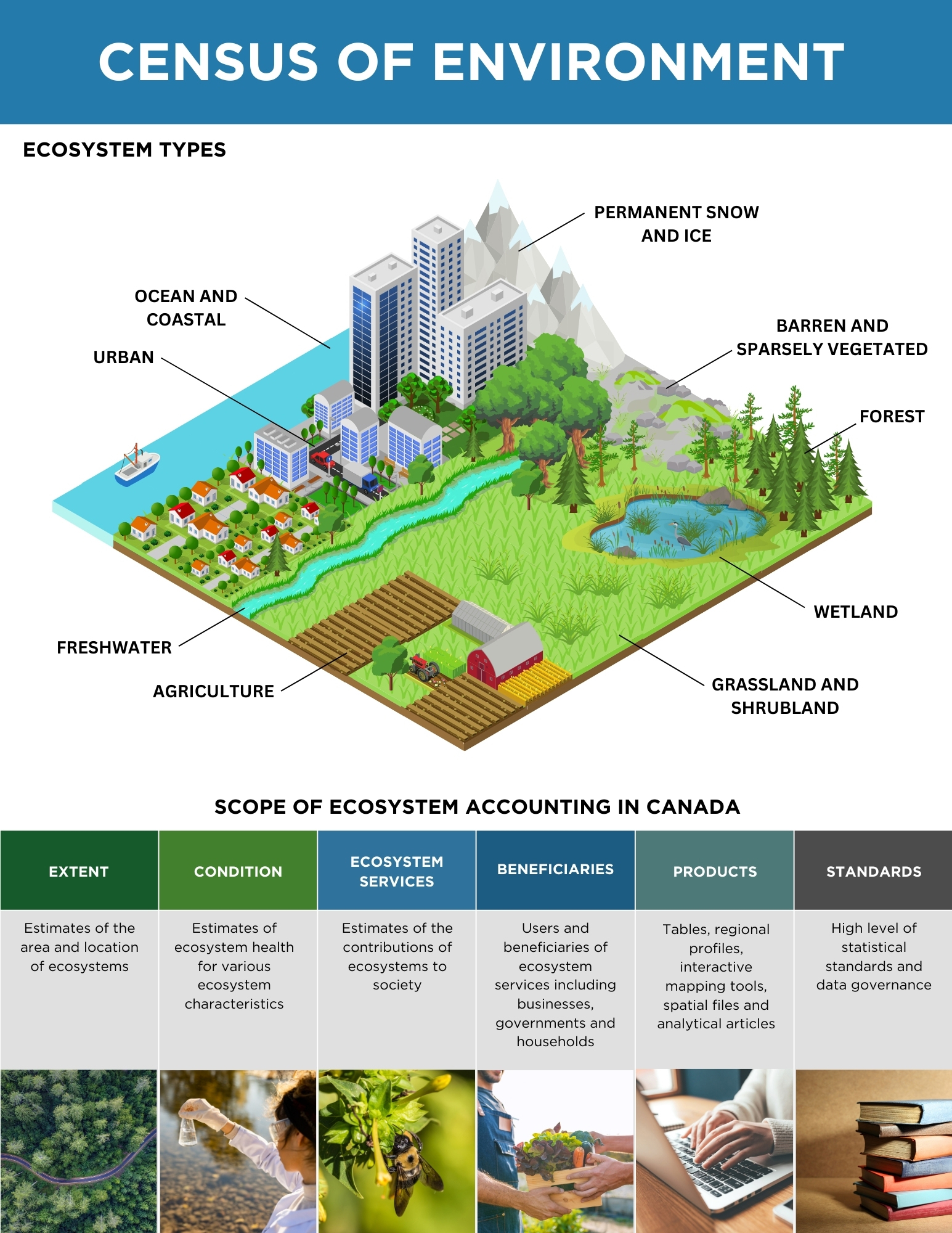
Description - Ecosystem accounting diagram
This graphic illustrates the types of ecosystems in Canada for which information will be produced as part of the Census of Environment. The image is titled "Ecosystem types" and is an illustration of a square polygon that depicts different ecosystem types in three dimensions, with labels attached with leader lines. Starting at the top left and moving counterclockwise, the following ecosystem types with labels are shown:
- ocean and coastal areas, which are depicted in blue with a boat
- urban areas, which are depicted by high-rise and mid-rise buildings (grey and blue buildings with urban vegetation and a streetscape) and a low-rise development (small, detached dwellings with red roofs and urban vegetation and streetscapes)
- freshwater areas, which are depicted by a turquoise water course
- agriculture areas, which are depicted by cropland areas with farm buildings
- grassland and shrubland areas, which are depicted by a flat green landscape with stylized shrub vegetation
- wetland areas, which are depicted by a blue pond with vegetation
- forest areas, which are depicted by coniferous and broadleaf tree vegetation
- barren and sparsely vegetated areas, which are depicted by grey rocks with green patches
- permanent snow and ice areas, which are depicted by grey mountains with snowy peaks.
At the bottom of the image is a table representing the scope of ecosystem accounting in Canada. The text in this table is as follows:
- extent—estimates of the area and location of ecosystems
- condition—estimates of ecosystem health for various ecosystem characteristics
- ecosystem services—estimates of the contributions of ecosystems to society
- beneficiaries—users and beneficiaries of ecosystem services, including businesses, governments and households
- products—tables, regional profiles, interactive mapping tools, spatial files and analytical articles
- standards—high level of statistical standards and data governance.
Planned evolution of the CoE
Over the next few years, the Census of Environment will deliver information on the extent and condition of ecosystems across the whole of Canada, including terrestrial, freshwater and marine areas. It will include intensively used systems such as urban areas and agricultural landscapes, as well as natural and semi-natural areas such as seagrass meadows, coastal wetlands, forests, grasslands and peatlands.
Collection and integration of data
The Census of Environment refers to the systematic and comprehensive creation, collection, compilation, and analysis of data related to ecosystems in Canada. But there is no questionnaire!
Sources of information include publicly available Earth observations and environmental monitoring datasets from other government departments (including Environment and Climate Change Canada, Natural Resources Canada, Agriculture and Agri-Food Canada, and Fisheries and Oceans Canada), as well as other key partners and organizations. The Census of Environment does not have one reference period or collection period since suitable datasets relate to different time periods and frequencies. Many of these datasets are currently being integrated.
Access to data
New Census of Environment products will be made available through this portal regularly. Data tables, infographics, mapping tools and analytical articles will be produced, and as the program develops, more data will be integrated.
Providing access to detailed spatial information and regional data is the key to understanding ecosystems in Canada. Spatial data files (for example, shape files and raster files) will be made available enabling expert users to benefit from the integrated ecosystem data produced through this program.
International standards, governance and engagement
The Census of Environment organizes data using the System of Environmental-Economic Accounting – Ecosystem Accounting international statistical standard. As a result, findings are compatible with other statistics, comparable from one end of the country to the other, and consistent with models developed elsewhere.
We maintain high standards of data governance and collaborate and engage with Indigenous partners and stakeholders to respond to policy needs. The Census of Environment will provide the statistical and spatial framework necessary to help track our performance towards meeting national and international goals including those identified in the Kunming-Montreal Global Diversity Framework guiding actions to preserve and protect nature and its essential services to people.
Frequently asked questions
What makes the Census of Environment a census?
The term 'census' in the context of the Census of Environment refers to the systematic and comprehensive creation, collection, compilation, and analysis of data related to ecosystem assets and services. The Census of Environment will measure ecosystems using data from many different sources, including satellite-derived Earth observation data, to produce integrated datasets on ecosystems and new insights on the services provided by nature.
What is the scope of the Census of Environment?
The CoE will gather information on the extent of ecosystems, report on their condition, and identify the flows of ecosystem services and who benefits from them. This information will be published as high-quality statistical products and made available through this website.
How is the CoE meeting environmental data needs to benefit Canadians?
The program is designed to link ecosystem data with socio-economic information to tell stories about the connections between ecosystems, human well-being, and the economy. It is supporting government efforts to address the impacts of climate changes on communities across Canada and to report against targets associated with the Global Biodiversity Framework.
Does Statistics Canada produce other environmental information?
The Census of Environment focuses on tracking changes in ecosystems and ecosystem services over time. But other environmental data is also available from Statistics Canada surveys and accounts. To find the wealth of information including data on solid waste and recycling, water use and wastewater, greenhouse gas emissions, clean technology, household environmental practices or environmental expenditures and environmental taxes, search the Environment statistics portal.