
Map 3.2
Risk of phosphorus release from agricultural soils, 2011
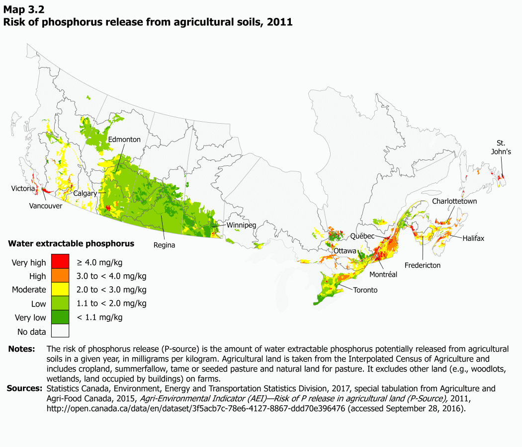
Description for Map 3.2
The title of this map is “Risk of phosphorus release from agricultural soils, 2011.” On this map, each colour represents a range of values for water extractable phosphorous potentially released from agricultural soils in a given year, in milligrams per kilogram, grouped into one of five risk classes. Category 1 (red) is greater than or equal to 4.0 mg/kg indicates a very high risk of phosphorus release, Category 2 (orange) is 3.0 to less than 4.0 mg/kg and indicates a high risk of phosphorus release, Category 3 (yellow) is 2.0 to less than 3.0 mg/kg and indicates a very moderate risk of phosphorus release, Category 4 (light green) is 1.1 to less than 2.0 mg/kg and indicates a very low risk of phosphorus release, Category 5 (dark green) is less than 1.1 mg/kg and indicates a very low risk of phosphorus release while Category 6 (white) represents regions where there is no data.
Some of the highest values for the risk of phosphorus release from agricultural soils in 2011 occurred in the Fraser–Lower Mainland, Newfoundland–Labrador, St. Lawrence, Saint John–Saint Croix and Maritime drainage regions.
On this map, a dark grey line represents drainage regions boundaries while a lighter grey line defines provincial and international boundaries. The locations and names of some major cities in each province are included. Water is pale blue.
Notes: The land use map is derived from remote sensing data products and administrative data sources. Water yield data were derived from discharge values contained in Environment and Climate Change Canada’s HYDAT database. Additional information is available in Appendix E.
Sources: Statistics Canada, Environment, Energy and Transportation Statistics Division, 2017, special tabulation from Agriculture and Agri-Food Canada, 2015, Land Use, 2010, (accessed September 16, 2015); Natural Resources Canada, 2009, Land cover, Circa 2000 - Vector, Earth Sciences Sector, Environment and Climate Change Canada , 2015, Water Survey of Canada, Archived Hydrometric Data Online, (accessed December 3, 2015); Statistics Canada, 2010, “Introducing a new concept and methodology for delineating settlement boundaries: A research project on Canadian settlements,” Environment Accounts and Statistics Analytical and Technical Paper Series, Catalogue no. 16-001-M, no. 11; and special tabulations by Statistics Canada, Business Survey Methodology Division to calculate the smoothed trends.
| Category | Milligrams per kilogram | Colour | Class |
|---|---|---|---|
| 1 | ≥ 4.0 | Red | Very high |
| 2 | 3.0 to < 4.0 | Orange | High |
| 3 | 2.0 to < 3.0 | Yellow | Moderate |
| 4 | 1.1 to < 2.0 | Light green | Low |
| 5 | < 1.1 | Dark Green | Very Low |
| 6 | White | No data |
| Ocean drainage areas and drainage regions | Code | Risk of phosphorus release (P-source), agricultural soils, 2011 |
|---|---|---|
| number | mg per kg | |
| Pacific Ocean | ||
| Pacific Coastal | 1 | 2.9 |
| Fraser–Lower Mainland | 2 | 3.3 |
| Okanagan–Similkameen | 3 | 2.6 |
| Columbia | 4 | 2.5 |
| Yukon | 5 | Note ...: not applicable |
| Arctic Ocean | ||
| Peace–Athabasca | 6 | 1.6 |
| Lower Mackenzie | 7 | 1.5 |
| Arctic Coast–Islands | 8 | Note ...: not applicable |
| Gulf of Mexico | ||
| Missouri | 9 | 1.6 |
| Hudson Bay | ||
| North Saskatchewan | 10 | 1.5 |
| South Saskatchewan | 11 | 1.8 |
| Assiniboine–Red | 12 | 1.3 |
| Winnipeg | 13 | 1.8 |
| Lower Saskatchewan–Nelson | 14 | 1.3 |
| Churchill | 15 | 1.6 |
| Keewatin–Southern Baffin Island | 16 | Note ...: not applicable |
| Northern Ontario | 17 | 2.9 |
| Northern Quebec | 18 | 3.5 |
| Atlantic Ocean | ||
| Great Lakes | 19 | 1.8 |
| Ottawa | 20 | 2.2 |
| St. Lawrence | 21 | 3.5 |
| North Shore–Gaspé | 22 | 2.2 |
| Saint John–St. Croix | 23 | 3.5 |
| Maritime Coastal | 24 | 3.2 |
| Newfoundland–Labrador | 25 | 6.3 |
- Date modified: