
Illustrated Glossary
Census division (CD)
Definition
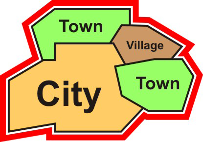
Group of neighboring municipalities joined together for the purposes of regional planning and managing common services (such as police or ambulance services). These groupings are established under laws in effect in certain provinces of Canada. Census division (CD) is the general term for provincially legislated areas (such as county, municipalité régionale de comté and regional district) or their equivalents. In other provinces and the territories where laws do not provide for such areas, Statistics Canada defines equivalent areas for statistical reporting purposes in cooperation with these provinces and territories. Census divisions are intermediate geographic areas between the province/territory level and the municipality (census subdivision).
For more information on census division, consult the Dictionary, Census of Population, 2016.
Census division tutorial
Census divisions have been established in provincial law in 6 of the 10 provinces to facilitate regional planning, as well as the provision of services that can be more effectively delivered on a scale larger than a municipality.
In Newfoundland and Labrador, Manitoba, Saskatchewan, Alberta, Yukon, Northwest Territories and Nunavut, provincial and territorial law does not provide for these administrative geographic areas. Therefore, Statistics Canada, in cooperation with these provinces and territories, has created equivalent areas called census divisions for the purpose of disseminating statistical data.
Census divisions provide an intermediate level of geography between the province and the census subdivision
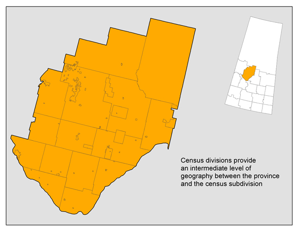
Description of map 1
Census divisions provide an intermediate level of geography between the province and the census subdivision
This map shows a close up view of one census division in Saskatchewan (Division No. 16) and its component census subdivisions to illustrate that census divisions provide an intermediate level of geography between the province and the census subdivision.
Source: Statistics Canada, Geography Division, 2016 Census of Population
Next to provinces and territories, census divisions are the most stable administrative geographic areas, and are therefore often used in longitudinal analysis. By using the census division code, which is based on the Standard Geographical Classification (SGC), users can track changes of a given census division over time.
In British Columbia, for example, the census division code '59 15' represents the census division of Greater Vancouver. The graph below shows the population trend in this census division over the past 40 years.
Chart Population of the census division of Greater Vancouver (British Columbia), 1971 to 2016
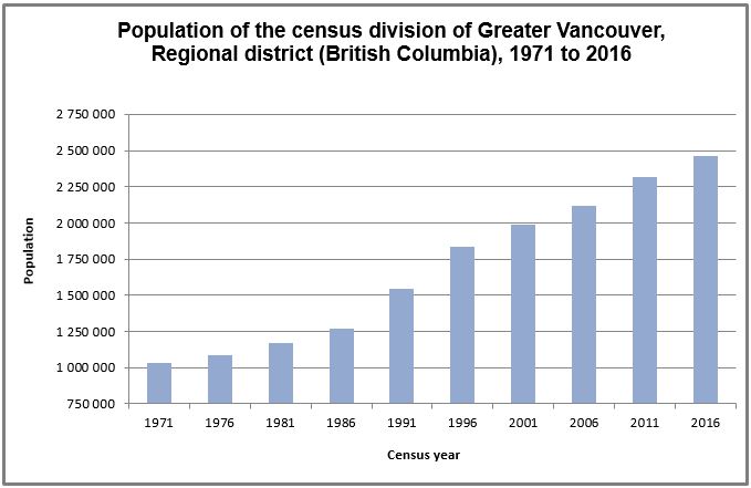
Description of chart 1
Population of the census division of Greater Vancouver (British Columbia), 1971 to 2016
This chart shows the population change in the census division of Greater Vancouver, Regional district (British Columbia) over the last 45 years, from 1971 to 2016. The population counts are: 1,028,334 in 1971; 1,085,242 in 1976; 1,169,831 in 1981; 1,266,152 in 1986; 1,542,744 in 1991; 1,831,665 in 1996; 1,986,965 in 2001; 2,116,581 in 2006; 2,313,328 in 2011 and 2,463,431 in 2016.
Source: Statistics Canada, Geography Division, 2016 Census of Population.
- Date modified: