

|
|
FindingsWinnipeg in context
How is crime distributed across Winnipeg neighbourhoods?
What is the population at risk? Calculating crime rates in small geographic areas
How does the spatial pattern of incidents change by time of day?
Neighbourhood characteristics and crime within neighbourhoods
Discussion
Winnipeg in context In 2001, the Winnipeg Census Metropolitan Area (CMA), with a population of 671,274, ranked eighth in terms of size among the 25 CMAs in Canada.5 The 2001 population was up 0.6% from 1996 (667,093), a rate of change that was similar to the average percentage change (0.7%) over the same period for the 25 CMAs. In 2001, the Winnipeg CMA represented approximately 60% of the population of the province of Manitoba. The City of Winnipeg, which is the focus of this demonstration study, falls within the larger CMA boundary and covers approximately 475 square kilometres, with a perimeter of 130 kilometres encompassing 230 neighbourhoods or Neighbourhood Characterization Areas (see definition in Text Box 1). The population of the study area in 2001 was 610,455. The area is served entirely by the Winnipeg Police Service, which employed a force of 1,127 officers operating out of 6 police stations and 8 community-based policing service centres. Zoning in Winnipeg is composed of roughly 19% single-family, 5.3% multiple-family and other types of residential; 3% commercial; 13% industrial; 7% parks and recreation areas; 35% agricultural and rural residential district; 0.5% downtown residential (primarily multiple-family); and 0.5% downtown non-residential (primarily commercial). This zoning accounts for roughly 83% of the 475 square kilometres within the study area boundary. The remaining 17% is associated with spaces such as street right of ways, rivers and other natural features. Since the mid 1990’s, the CMA of Winnipeg has reported crime rates among the highest in the country. In 2001, the CMA ranked 4th behind Regina, Saskatoon and Vancouver. Figure 1 compares Winnipeg’s crime rate to the overall rate in Canada from 1991 to 2002. While both rates were generally declining in the 1990s, the drop was been less dramatic in Winnipeg, and beginning in 1999, Winnipeg experienced three years of increase prior to 2002. Figure 1
Crime rate Winnipeg and Canada, 1991 to 2002 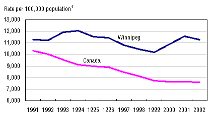 1. Rates based on count of total Criminal Code incidents excluding traffic offences.
Sources: Statistics Canada, 1991-2002 UCR; Statistics Canada, 2001 Census. Categories of offences considered in this study include: violent, property, drug, prostitution, offensive weapons, and gaming and betting offences. In 2001, the Winnipeg Police Service reported over 66,000 of these incidents, the vast majority of which were property crimes (83%), followed by violent (15%), and other offences (2%) including prostitution, drugs, offensive weapons and gaming and betting. These results are similar to the distribution of offences in Canada overall in 2001 (79%, 17 % and 4%), as well as the results reported by other police services in the West including Calgary, Edmonton and Regina. For about one-quarter or nearly 16,000 incidents one or more accused persons were identified. Among accused persons, most were adult males (57%), women accounted for 14%, with male (20%) and female (7%) youth aged 12-17 years, and children under the age of 12 (2%) accounting for the remainder. The peak offending years among accused identified by the police in Winnipeg were 15 to 19 (Figure 2) and this is similar to the peak ages overall in Canada. Figure 2
Age distribution of accused, Winnipeg, 2001 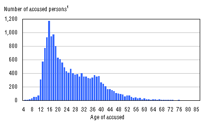 1. Based on 17,227 accused persons aged 4 to 87 years, about 16,000 incidents for which one or more accused persons were identified.
Source: Statistics Canada, 2001 UCR2.
How is crime distributed across Winnipeg neighbourhoods? While reported incidents were located in 228 of the 230 NCAs, a closer look at the distribution of incidents reveals that reported crime is not evenly distributed across the city. Maps 3 and 4 show spatial distributions by NCAs for violent and property crimes, where dark blue represents the highest crime NCAs.6 About 30% of reported violent crime incidents in 2001 occurred in 3% of NCAs, and 30% of reported property crime incidents occurred in 7% of NCAs.7 Map 3. Distribution of violent crime incidents by NCA, Winnipeg, 2001 Map 4. Distribution of property crime incidents by NCA, Winnipeg, 2001 The concentration of crime within cities in relatively few areas has been noted in other studies (Sherman, Gartin and Buerger 1989; Brantingham and Brantingham 1982). In Winnipeg, much of the reported crime in 2001 was clustered in neighbourhoods that are in the core and north of the core. One method of visualizing this is to examine the density of reported incidents per square kilometre. Map 5 displays densities within 2 kilometre concentric rings moving out from the geographic centre of the city. Roughly 1,100 incidents per square kilometre were reported in the core area indicated by the darkest colour. Moving out from the core, the density of reported incidents drops dramatically to 431, 259 and 151 incidents per square kilometre in each successive concentric ring. Map 5. Concentration of incidents, density per square kilometre, Winnipeg, 2001 The location of clusters of violent and property incidents or “hot spots” (indicated by the darkest red colour) are displayed in Maps 6 and 7. The first map displays more clearly that those areas with the highest relative densities of violent crime are in the urban core and to the north. Although this is also true for property crime, there is a wider distribution of concentration spread further from the core. Hot spots outside of the city centre are located in major shopping areas of the city. Maps showing the location of hot spots within the City for selected individual offence types are shown in Appendix A. Map 6. Kernel density distribution of violent crime incidents, Winnipeg, 2001 Map 7. Kernel density distribution of property crime incidents, Winnipeg, 2001
Text Box 2 : What is the population at risk? Calculating crime rates in small geographic areas
The typical approach to calculating crime rates is to look at the distribution of incidents per residential population in a given area. While this approach works well at a city, provincial or national level, difficulty arises when the spatial areas of interest are small, for example neighbourhoods, with correspondingly small residential populations.
The distribution of criminal incidents across urban areas is often concentrated in or near the city centre, where residential populations are relatively low, but where there are otherwise high concentrations of people either working or spending time in other ways. Rates based on residential population alone will artificially inflate the crime rates in these urban core neighbourhoods since the total population at risk in these areas has not been taken into account (see for example, Oberwittler and Wiesenhütter 2002).
While information about the true population at risk does not currently exist in any precise form, alternative approaches to calculating crime rates for small geographic areas have been proposed by Oberwittler (in press) and Wikstrom (1991). These include combining the residential population with different counts of population such as the number of people entering a given neighbourhood on public transit (Oberwittler in press) or the number of people working in a given neighbourhood (Wikstrom 1991). Rates based on these combined populations more closely approximate the total number of people at risk of experiencing crime. While it could be argued that these rates are more appropriate for understanding the distribution of violent crimes that require a victim, they may also serve as an improved measure for property crime since a count of residents and workers provides a better approximation of the numbers of dwellings and businesses that may be the targets of property crime. Table 1 compares results for rates based on two different measures of the ‘population at risk’ in Winnipeg neighbourhoods which are used as the denominator in the calculation of rates: residential population alone and residential plus the employed labour force population. (1) Using the residential population for each NCA there are on average 148 incidents per 1,000 residents. At a minimum, neighbourhoods experience 15 incidents per 1,000 residents, whereas the highest rate is just less than 4,400 incidents per 1,000 residents. When only violent offences are considered, the highest rate was 235 incidents per 1,000 residents as compared to property offences alone where the highest rate was about 4,100 incidents per 1,000 residents. (2) The employed labour force population for each NCA is taken from the 2001 Census and refers to the number of people whose regular place of work is within the boundaries of the NCA. This figure was added to the residential population for each NCA to approximate the ‘population at risk’. Based on this measure, the neighbourhood average decreases to about 70 incidents per 1,000 persons at risk, while the highest rate is 348. The highest rates for violent (88) and property crime (229) are also reduced. To more accurately gauge risk of crime within NCAs, subsequent multivariate analyses in this paper will include crime rates based on the population at risk using residential and employed labour force combined. Table 1. Count and rate of police-reported crime incidents in Winnipeg neighbourhoods, 2001 (Excel, CSV)
Map 8 displays the combination of the distribution of property incidents and residential population alone; while Map 9 shows the combination of property incidents with the ‘population at risk’ which includes both the residential and employed populations in each NCA (see Text Box 2).8 These maps point to important differences in the distribution of reported criminal activity across the City. In particular, when the broader measure of population at risk is used, the density distribution is widened to more areas beyond the city centre. This difference is even more evident when examining the distribution of violent crime (Maps 10 and 11). Map 8. Kernel density distribution of property incidents and residential population, Winnipeg, 2001 Map 9. Kernel density distribution of property incidents and population at risk (combined residential and employed population), Winnipeg, 2001 Map 10. Kernel density distribution of violent incidents and residential population, Winnipeg, 2001 Map 11. Kernel density distribution of violent incidents and population at risk (combined residential and employed population), Winnipeg, 2001
How does the spatial pattern of incidents change by time of day? In combination with the location of crime, the time of occurrence is particularly important from the perspective of a crime reduction strategy. Although criminal incidents can occur at any time, research indicates that different types of crimes are concentrated at certain times of the day (Assuncao, Beato, Silva 2002). As an example, distributions of reported incidents of robbery by time of day for all reported incidents in 2001 are shown in Figure 3. Since criminal offences may occur over an extended period of time, the UCR2 survey collects both the reported starting time of the offence and the reported completion time. Columns in the figure below represent the reported completion time of the incidents. A pattern emerges for robbery offences with the fewest incidents occurring in the morning hours and the peak occurring in the evening before midnight. Figure 3
Robbery incidents by time of day, Winnipeg, 20011 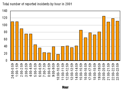 1. Includes 1,652 reported robbery incidents where the time of the incident was known.
Source: Statistics Canada, 2001 UCR2. Maps 12 through 14 show the distribution of robbery incident hot spots at three points during the day: morning (7:00 to 9:00); evening (20:00 to 22:00) and night (1:00 to 3:00). In 2001, 4% of reported robberies occurred between 7:00 and 9:00 AM, 14% between 8:00 and 10:00 PM and 12% between 1:00 and 3:00 AM. The spatial distributions differ depending on the time of day, with variation in both the amount of crime and also in the location of the highest crime density areas or ‘hot spots’ identified by the darkest red colour. Map 12. Kernel density distribution of morning robbery incidents, 7:00-9:00 AM, Winnipeg, 2001 Map 13. Kernel density distribution of evening robbery incidents, 8:00-10:00 PM, Winnipeg, 2001 Map 14. Kernel density distribution of night time robbery incidents, 1:00-3:00 AM, Winnipeg, 2001
Neighbourhood characteristics and crime within neighbourhoods9 Since the 1940s (Shaw and McKay 1942) numerous studies have documented the relationship between neighbourhood characteristics and rates of crime. These studies however, have differed with respect to their emphasis on the importance of factors such as low income, residential mobility, ethno-cultural composition, opportunities for criminal behaviour, collective efficacy (or the level of trust and reciprocity in a neighbourhood), and social disorganization (or a decrease in the influence of social rules over behaviour) (Cohen and Felson 1979; Brantingham & Brantingahm 1982; Roncek & Maier 1991; Sampson and Lauritsen 1994; Sampson et al. 1997; Oberwittler in press). This section explores the relationship between many of these factors and 2001 rates of violent and property crime within Winnipeg NCAs. The analysis makes use of total violent and property crime rates rather than rates for individual offence types to maximize the number of incidents being considered. The analysis is based on Neighbourhood Characterization Areas with residential populations greater than 250 people. Statistics Canada suppresses income data for geographies below this level for reasons of confidentiality and data quality.10 As a result, only 175 of the 230 Neighbourhood Characterization Areas are included. Characteristics considered in this analysis have been derived from the 2001 Census and City of Winnipeg zoning data and are outlined in the Description of variables. Descriptive results: a comparison of high- and low-crime neighbourhoods To examine the relationship between violent and property crime rates and selected neighbourhood characteristics, the 175 NCAs are divided into two groups for each crime type. The first group contains NCAs falling into the highest 25% of property and violent crime rates, and the second group contains the remaining 75% of NCAs.11 Before controlling for other factors, there are significant differences in selected characteristics when neighbourhoods with higher rates of crime are compared to their lower crime rate counterparts. These differences in crime rates are consistent across a number of neighbourhood residential characteristics, zoning and dwelling characteristics and socio-economic characteristics for both violent and property crimes. For instance, Figure 4 shows that when compared to the other group, NCAs with the highest violent crime rates had, on average, significantly greater percentages of residential mobility or people who did not reside at the same address one year prior to the 2001 Census compared to lower violent crime NCAs (22% and 13%, respectively); greater percentages of recent immigrants arriving to Canada between 1991 and 2001 (29% and 18%, respectively); greater percentages of Aboriginal residents (19% and 5%, respectively),12 and greater percentages of female lone-parent families (24% and 12%, respectively). Similar differences were found with respect to property crimes (Figure 5). Figure 4
Population characteristics in neighbourhoods with high and lower rates of violent crime, Winnipeg, 2001 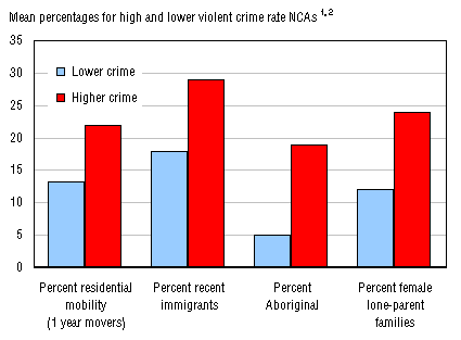 1. High-crime = NCAs falling into the highest 25% of violent crime rate neighbourhoods; lower-crime = remaining 75%. Rate per 1,000 residential and employed population.
2. Differences between high-crime and lower-crime means are statistically significant at: p<0.001.
N = 175 Neighbourhood Characterization Areas
Sources: Statistics Canada, 2001 UCR2; Statistics Canada, 2001 Census. Figure 5
Population characteristics in neighbourhoods with high and lower rates of property crime, Winnipeg, 2001 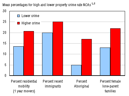 1. High-crime = NCAs falling into the highest 25% of property crime rate neighbourhoods; lower-crime = remaining 75%. Rate per 1,000 residential and employed population.
2. Differences between high-crime and lower-crime means are statistically significant at: p<0.001.
N = 175 Neighbourhood Characterization Areas
Sources: Statistics Canada, 2001 UCR2; Statistics Canada, 2001 Census. With respect to land-use characteristics, neighbourhoods with the highest rate of violent crime had significantly greater proportions of commercial zoning than lower crime neighbourhoods (15% and 5%, respectively); greater proportions of multiple-family residential zoning (30% and 8%, respectively); and lower levels of single-family zoning (18% and 38%, respectively) (Figure 6). On average, a greater proportion of housing in high violent crime rate areas was in need of major repairs (12% and 8%, respectively) and was older, built before 1961 (60% and 36%, respectively). There were also lower proportions of owner-occupied dwellings in high violent crime NCAs (43% and 76%, respectively), and greater proportions of unaffordable housing represented by households spending more than 30% of their income on shelter (30% and 17%, respectively). These differences in land-use and housing characteristics were similar for property crime (Figure 7). Figure 6
Land-use and housing characteristics in neighbourhoods with high and lower rates of violent crime Winnipeg, 2001 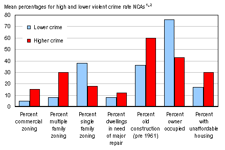 1. High-crime = NCAs falling into the highest 25% of violent crime rate neighbourhoods; lower-crime = remaining 75%. Rate per 1,000 residential and employed population.
2. Differences between high-crime and lower-crime means are statistically significant at: p<0.001.
N = 175 Neighbourhood Characterization Areas
Sources: Statistics Canada, 2001 UCR2; Statistics Canada, 2001 Census. Figure 7
Land-use and housing characteristics in neighbourhoods with high and lower rates of property crime Winnipeg, 2001 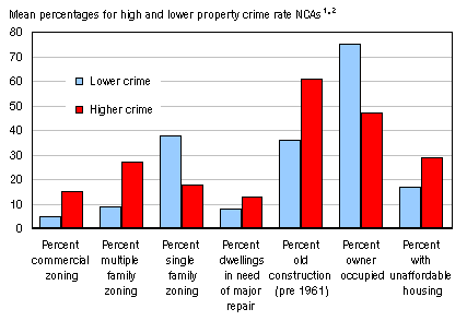 1. High-crime = NCAs falling into the highest 25% of property crime rate neighbourhoods; lower-crime = remaining 75%. Rate per 1,000 residential and employed population.
2. Differences between high-crime and lower-crime means are statistically significant at: p<0.001.
N = 175 Neighbourhood Characterization Areas
Sources: Statistics Canada, 2001 UCR2; Statistics Canada, 2001 Census. Finally, Figure 8 points to the presence of concentrated socio-economic disadvantage in higher violent crime rate neighbourhoods, evidenced by significantly greater percentages of population receiving government transfers (23% and 11%, respectively), without completion of high school (27% and 18%, respectively), with incomes below the low income cut-off (39% and 13%, respectively) and unemployed (9% and 5%, respectively). In addition, these neighbourhoods have significantly lower median household incomes when compared to neighbourhoods with lower violent crime rates ($28,000 and $57,000, respectively). Figure 9 indicates similar results for property crime rates. Figure 8
Socio-economic characteristics in neighbourhoods with high and lower rates of violent crime, Winnipeg, 2001 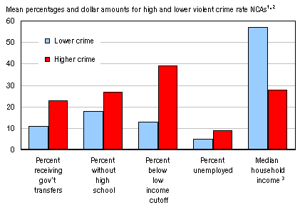 1. High-crime = NCAs falling into the highest 25% of violent crime rate neighbourhoods; lower-crime = remaining 75%. Rate per 1,000 residential and employed population.
2. Differences between high-crime and lower-crime means are statistically significant at: p<0.001.
3. Median household income in $1,000s.
N = 175 Neighbourhood Characterization Areas
Sources: Statistics Canada, 2001 UCR2; Statistics Canada, 2001 Census. Figure 9
Socio-economic characteristics in neighbourhoods with high and lower rates of property crime, Winnipeg, 2001 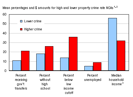 1. High-crime = NCAs falling into the highest 25% of property crime rate neighbourhoods; lower-crime = remaining 75%. Rate per 1,000 residential and employed population.
2. Differences between high-crime and lower-crime means are statistically significant at: p<0.001.
3. Median household income in $1,000s.
N = 175 Neighbourhood Characterization Areas
Sources: Statistics Canada, 2001 UCR2; Statistics Canada, 2001 Census. As would be expected, results for the composite socio-economic disadvantage variable (based on the combination of the 5 variables, see definition in Description of variables section) indicate a similar pattern in which the highest crime neighbourhoods have the highest levels of disadvantage.13 There were, however, no significant neighbourhood differences for some of the factors that were analyzed including the proportion of males in the high risk age group (15-24 years) and the proportion of older adults aged 64 and over. Multivariate Results When considered individually, the neighbourhood characteristics discussed above are associated with violent and property crime rates in neighbourhoods. However, the extent of this association can vary when multiple characteristics are considered together. Multivariate analysis in this section is used to examine the interrelationships among variables and to observe how they relate to the level of crime after taking other factors into account.14 Many of the neighbourhood characteristics in this study are highly correlated with each other or convey essentially the same information. This multicollinearity between factors stems from the strong association among many of the structural factors that are individually linked to crime (Land, McCall & Cohen 1990). To avoid the problem of multicollinearity, which may distort the results, highly correlated variables were eliminated from the analysis. For instance, Table 2 shows that the proportion of lone-parent families (r=.81), Aboriginal population (r=.82), owner-occupied dwellings (r=.73) and unaffordable housing (r=.76) are all highly correlated with socio-economic disadvantage and consequently were removed from the multivariate analysis.15 As has been mentioned earlier in this report, the ‘socio-economic disadvantage’ variable is a composite of five related factors which reflect the level of social and economic resources available to individuals. Although the additional highly correlated variables listed here were not included as part of the composite ‘disadvantage’ variable, they are also strongly associated with the concept. In fact it could be argued that their effect on crime is a result of their strong connection to disadvantage. As one might expect, Table 2 also indicates that the proportion of single-family residential zoning is highly correlated with multiple-family residential zoning (r=-.72). Typically, single-family zoning increases as the proportion of multiple-family zoning decreases. In order to achieve the most parsimonious results, multiple-family zoning was maintained for the multivariate analysis, since previous research has demonstrated links between the cost and density of housing and concentrated crime (South & Crowder 1997). Finally, results indicate a strong correlation between the proportion of older homes (built before 1961) and the proportion of dwellings in need of major repair (r=.75). In this case, housing built before 1961 was dropped from the multivariate analysis, primarily because the state of repair of housing is considered to be an important factor associated with increased social disorder and consequently higher crime rates (Kelling & Coles 1998). Table 2. Bivariate correlations of independent variables, Winnipeg neighbourhoods, 2001 (Excel, CSV) To assess the relative contribution of neighbourhood characteristics to the explanation of crime, the set of variables was regressed separately on violent and property crime rates (Table 3). The adjusted r-square values indicate that the 8 remaining explanatory variables account for a very high percentage of the variation in violent crime (76%) and property crime (66%). The estimated regression coefficients provide an indication of the relative contribution of each variable after controlling for the other variables in the model.16 Socio-economic disadvantage makes the largest relative contribution to the explanation of both violent (b=0.78) and property (b=0.54) crime rates, after adjusting for, or holding constant, the other explanatory variables. In both models, as the level of socio-economic disadvantage increases, so do the violent and property crime rates. Disadvantage is followed in importance by the relative contribution of the condition of housing in the neighbourhood, indicated by the proportion of dwellings in need of major repairs (b=0.25 and b=0.40). As the proportion of dwellings in need of major repair increases, so do the violent and property crime rates net of the other variables in the model. Other variables that made smaller, though statistically significant, contributions to an increase in violent crime rates after adjusting for other variables include an increase in the percentage of multiple-family zoning (b=0.14), an increase in the percentage of commercial zoning (b=0.12), a decrease in the proportion of older adults aged over 64 years (b=-0.12) and an increase in the high risk victim/offender population of males aged 15-24 (b=0.10). Neither the proportion of immigrants in the neighbourhood, nor the proportion of residents living at a different address in the previous year made significant contributions to the explanation of the violent crime rate after controlling for the other variables in the model. With respect to property crime, the percentage of commercial zoning (b=0.25) followed socio-economic disadvantage and dwellings in need of repair in terms of relative importance, and was the only other variable to make a significant contribution to the explanation of the property crime rate. Net of the other variables, an increase in the proportion of commercial zoning in a neighbourhood was related to increases in the property crime rate. Table 3. OLS-multiple regression models for violent and property rates, Winnipeg neighbourhoods, 2001 (Excel, CSV)
Discussion This report has presented information from a Statistics Canada pilot study of the spatial distribution of crime in a Canadian city using a combination of statistical analyses and crime mapping based on Geographic Information System (GIS) technology. Results from the examination of 2001 Winnipeg data are in agreement with those from other studies indicating that crime is not randomly distributed across cities, but rather is concentrated in certain areas that are associated with other factors related to the population and land-uses of the city. Maps of the distribution of police-reported criminal incidents in this report show a concentration in the core of the city representing a relatively small geographic area. For example, about 1,100 incidents per square kilometre were reported within a 2 kilometre radius of the geographic centre of the city. However, between 6 and 8 kilometres from the centre, the density of reported incidents drops dramatically to 151 incidents per square kilometre. There are some differences in the degree of concentration of violent and property crime. About 30% of reported violent crime incidents in 2001 occurred in 3% of neighbourhoods, and although there is a wider distribution of property crime incidents, about 30% of reported property crime occurred in just 7% of neighbourhoods. Before controlling for other factors, results point to significant differences in selected characteristics when neighbourhoods with the highest rates of crime are compared to their lower crime rate counterparts. Differences in crime rates are consistent across a number of neighbourhood residential characteristics, land-use and dwelling characteristics and socio-economic characteristics for both violent and property crimes. These bivariate results suggest that higher levels of crime occur in areas with reduced access to social and economic resources. For example, these neighbourhoods are characterized by populations that are more economically disadvantaged, less educated, more likely to have higher numbers of female single-parent families, Aboriginal residents and/or recent immigrants. The neighbourhoods also tend to exhibit lower levels of residential stability, to be more crowded and to have greater proportions of multiple-family dwellings which are often in need of repair. It was demonstrated in this study that many of these individual factors are closely related. Thus, when the variables were held constant through the use of a multivariate technique, a few key factors were shown to be most highly related to both property and violent crime rates. After controlling for other variables, socio-economic disadvantage had the greatest significant association with violent and property crime. The strong association between concentrated disadvantage and crime has been demonstrated frequently in other research. For example, Sampson and Raudenbush (1999) have argued that the relationship between disadvantage and crime is in fact so strong that other “symptoms” of high-crime neighbourhoods actually stem from the socio-economic disadvantage. Disadvantage was followed in importance by the relative contribution of the condition of housing in the neighbourhood, indicated by the proportion of dwellings in need of major repair. This factor is an indication of lower community affiliation, a lower sense of community responsibility leading to a disconnection from identification with and interest in neighbours and neighbourhood (Sampson and Raudenbush 1999). Land-use types also contributed to the explanation of crime. With respect to violent crime, this was particularly the case for multiple-family zoning, and to a lesser extent was also valid for commercial zoning which included, among other businesses, restaurants, beverage hotels and retail establishments. The results for property crime were somewhat different. In this case, commercial zoning was the only land-use type that proved to be significant. Opportunities for crime increase when neighbourhood land-use patterns are conducive to crime (Hayslett-McCall 2002) . Land-uses that have been associated with crime include mixed patterns of residential, commercial, industrial, and vacant lands within neighbourhoods, as well as the presence of particular establishments, such as shopping malls. Land-use patterns can influence crime by inhibiting the social control or guardianship capacity of residents in a neighbourhood or by being a focal point for particular types of activities (e.g., consuming alcohol at a bar, selling/using drugs in abandoned structures) (Hayslett-McCall 2002). This study has demonstrated that high-crime neighbourhoods exhibit distinct characteristics that are quite different from low-crime neighbourhoods. They are characterized by residential populations with smaller shares of social and economic resources, and by land-use patterns that may increase opportunities for crime to be committed. These results suggest that effective community level interventions would include programs and policies that improve the socio-economic conditions of residents including housing and take into account the implications of land-use zoning. Moreover, the high level of geographic concentration found in this study suggests that there may be some benefit to targeting strategies to the particular needs of neighbourhoods or smaller areas within a city. Limitations and opportunities Work undertaken in the Winnipeg demonstration study was limited to a single year of data. Consequently it was not possible to examine change in neighbourhood crime rates and associated characteristics. Temporal data provides the opportunity to examine the causal ordering of different factors. For instance, studies of American cities suggest that high crime leads to depopulation which in turn leads to an increase in socio-economic disadvantage in urban core areas. Understanding factors related to change over time is also important for the development of prevention and reduction strategies and for the evaluation of existing programs. Future work should consider multiple years of data and consequently change over time. While this study provided information about the location of the criminal incidents, no data were available on the location of either accused or victim residences. Information about travel-to-crime patterns, or the distances offenders travel to commit crimes, can be used to shape appropriate crime reduction strategies. While it is often assumed that offenders travel distances to commit crime, and that a considerable amount of crime is committed by the same high-volume offenders travelling to different parts of the city, evidence from the UK suggests that most offender movements are relatively short and travel associated with crime is driven by opportunities presenting themselves during normal routines rather than plans to offend. To test these results in the Canadian context, accused address information could be examined. Some initial work was undertaken in the Winnipeg demonstration study to examine factors that distinguish neighbourhoods with lower levels of crime despite having characteristics typically associated with high-crime neighbourhoods. The characteristics and locations of these neighbourhoods are of particular interest from an intervention perspective since they may possess certain protective attributes. However, the very strong relationship between crime and disadvantage in Winnipeg meant that the small numbers of these low-crime/higher-disadvantage neighbourhoods yielded unreliable results. Consequently, it was not possible to describe the attributes of these neighbourhoods. More work in this area could be undertaken in other Canadian cities. Finally, analyses of the spatial distribution of crime are particularly affected by the availability of data. This study relied on the Census of Population and City of Winnipeg zoning data to describe the relationship between location and crime. While this information contributes to an understanding of crime patterns in cities, there are other factors that could be related to the people who flow in and out of a neighbourhood over the course of a day, the locations of specific land-use types (e.g., bars and nightclubs), the location and delivery of various justice and non-justice services and most importantly about individuals’ attitudes and perceptions regarding their own neighbourhood, their trust in others and their willingness to participate. Improved understanding of factors associated with crime distribution requires access to data sets from a variety of sources.
As a convenience to users, Statistics Canada sometimes provides files in proprietary formats. We do not, however, provide technical support.
You can download a free viewer for a Microsoft Office application from the Microsoft Office website. If you require assistance, please contact Microsoft.
|

