
Publications
Boundary Files, Reference Guide
Section 2 Overview
The 2011 Census Boundary Files depict boundaries of standard geographic areas established for the purpose of disseminating census data. A diagram illustrating the hierarchy of standard geographic units is included in Appendix B of this guide.
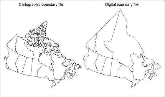
The 2011 Census Boundary Files provide a framework for mapping and spatial analysis. They are available for download in two types: cartographic and digital. Cartographic boundary files depict the geographic areas using only the shorelines of the major land mass of Canada and its coastal islands. Digital boundary files depict the full extent of the geographic areas, including the coastal water area. Figure 2.1 illustrates an example of cartographic and digital boundary files.
The 2011 Census Boundary Files are similar to the 2006 Census Boundary Files in format. New for the 2011 Census, each boundary file includes the unique identifiers, names and types (where applicable) of all higher level geographic areas available at time of release.
Figure 2.1 Example of a cartographic boundary file and a digital boundary file (provinces and territories)
Cartographic and digital boundary files are portrayed in latitude and longitude coordinates (North American Datum of 1983 [NAD83]). They are available for the following geographic areas:
- provinces and territories
- census divisions
- economic regions
- census metropolitan areas and census agglomerations
- census consolidated subdivisions
- census subdivisions
- federal electoral districts (2003 Representation Order)
- census tracts
- dissemination areas
- dissemination blocks
- population centres (available February 8, 2012)
- designated places (available February 8, 2012)
- census division population ecumene (available February 8, 2012)
- census forward sortation areas (available October 24, 2012)
Hydrographic reference files are also available:
- coast
- lakes
- rivers
How to cite this guide
Boundary Files, Reference Guide, First edition, 2011 Census. Statistics Canada Catalogue no. 92-160-G.
How to cite this product
Boundary Files, 2011 Census . Statistics Canada Catalogue no. 92-160-X.
Dissemination Block Boundary File, 2011 Census . Statistics Canada Catalogue no. 92-163-X.
Census Tract Boundary File, 2011 Census . Statistics Canada Catalogue no. 92-168-X.
Dissemination Area Boundary File, 2011 Census . Statistics Canada Catalogue no. 92-169-X.
Federal Electoral District Boundary File, 2011 Census . Statistics Canada Catalogue no. 92-171-X.
- Date modified: