Archived - Annual Survey of Secondary Distributors of Refined Petroleum Products - 2020
Why are we conducting this survey?
This survey is conducted by Statistics Canada in order to collect the necessary information to support the Integrated Business Statistics Program (IBSP). This program combines various survey and administrative data to develop comprehensive measures of the Canadian economy.
The purpose of this survey is to obtain information on the volume of refined petroleum products distributed by secondary distributors in Canada. It supplements energy consumption data collected from the refineries in the Annual Survey of End Use of Refined Petroleum Products.
Your information may also be used by Statistics Canada for other statistical and research purposes.
Your participation in this survey is required under the authority of the Statistics Act.
Other important information
Authorization to collect this information
Data are collected under the authority of the Statistics Act, Revised Statutes of Canada, 1985, Chapter S-19.
Confidentiality
By law, Statistics Canada is prohibited from releasing any information it collects that could identify any person, business, or organization, unless consent has been given by the respondent, or as permitted by the Statistics Act. Statistics Canada will use the information from this survey for statistical purposes only.
Record linkages
To enhance the data from this survey and to reduce the reporting burden, Statistics Canada may combine the acquired data with information from other surveys or from administrative sources.
Data-sharing agreements
To reduce respondent burden, Statistics Canada has entered into data-sharing agreements with provincial and territorial statistical agencies and other government organizations, which have agreed to keep the data confidential and use them only for statistical purposes. Statistics Canada will only share data from this survey with those organizations that have demonstrated a requirement to use the data.
Section 11 of the Statistics Act provides for the sharing of information with provincial and territorial statistical agencies that meet certain conditions. These agencies must have the legislative authority to collect the same information, on a mandatory basis, and the legislation must provide substantially the same provisions for confidentiality and penalties for disclosure of confidential information as the Statistics Act. Because these agencies have the legal authority to compel businesses to provide the same information, consent is not requested and businesses may not object to the sharing of the data.
For this survey, there are Section 11 agreements with the provincial and territorial statistical agencies of Newfoundland and Labrador, Nova Scotia, New Brunswick, Québec, Ontario, Manitoba, Saskatchewan, Alberta, British Columbia and the Yukon. The shared data will be limited to information pertaining to business establishments located within the jurisdiction of the respective province or territory. Section 12 of the Statistics Act provides for the sharing of information with federal, provincial or territorial government organizations.
Under Section 12, you may refuse to share your information with any of these organizations by writing a letter of objection to the Chief Statistician, specifying the organizations with which you do not want Statistics Canada to share your data and mailing it to the following address:
Chief Statistician of Canada
Statistics Canada
Attention of Director, Enterprise Statistics Division
150 Tunney's Pasture Driveway
Ottawa, Ontario
K1A 0T6
You may also contact us by email at Statistics Canada Help Desk or by fax at 613-951-6583.
For this survey, there are Section 12 agreements with the statistical agencies of Prince Edward Island, the Northwest Territories and Nunavut as well as with the Newfoundland and Labrador Department of Natural Resources, New Brunswick Department of Environment and Local Government, the ministère des Finances du Québec, the ministère de l'Environnement et de la Lutte contre les changements climatiques du Québec, the ministère de l'Énergie et des Ressources naturelles du Québec, Transition énergétique Québec, the Manitoba Department of Mineral Resources, the British Columbia Ministry of Energy and Mines, the British Columbia Ministry of Natural Gas Development, Canada Energy Regulator, Natural Resources Canada and Environment and Climate Change Canada.
For agreements with provincial and territorial government organizations, the shared data will be limited to information pertaining to business establishments located within the jurisdiction of the respective province or territory.
Business or organization and contact information
1. Verify or provide the business or organization's legal and operating name and correct where needed.
Note: Legal name modifications should only be done to correct a spelling error or typo.
Note: Press the help button (?) for additional information.
Legal Name
The legal name is one recognized by law, thus it is the name liable for pursuit or for debts incurred by the business or organization. In the case of a corporation, it is the legal name as fixed by its charter or the statute by which the corporation was created.
Modifications to the legal name should only be done to correct a spelling error or typo.
To indicate a legal name of another legal entity you should instead indicate it in question 3 by selecting 'Not currently operational' and then choosing the applicable reason and providing the legal name of this other entity along with any other requested information.
Operating Name
The operating name is a name the business or organization is commonly known as if different from its legal name. The operating name is synonymous with trade name.
Legal name
Operating name (if applicable)
2. Verify or provide the contact information of the designated business or organization contact person for this questionnaire and correct where needed.
Note: The designated contact person is the person who should receive this questionnaire. The designated contact person may not always be the one who actually completes the questionnaire.
- First name
- Last name
- Title
- Preferred language of communication
- English
- French
- Mailing address (number and street)
- City
- Province, territory or state
- Postal code or ZIP code
- Country
- Canada
- United States
- Email address
- Telephone number (including area code)
- Extension number (if applicable)
- The maximum number of characters is 10.
- Fax number (including area code)
3. Verify or provide the current operational status of the business or organization identified by the legal and operating name above.
- Operational
- Not currently operational
Why is this business or organization not currently operational?
- Seasonal operations
- Ceased operations
- Sold operations
- Amalgamated with other businesses or organizations
- Temporarily inactive but will re-open
- No longer operating due to other reasons
When did this business or organization close for the season?
Date
When does this business or organization expect to resume operations?
Date
When did this business or organization cease operations?
Date
Why did this business or organization cease operations?
- Bankruptcy
- Liquidation
- Dissolution
- Other
Specify the other reasons why the operations ceased
When was this business or organization sold?
Date
What is the legal name of the buyer?
When did this business or organization amalgamate?
Date
What is the legal name of the resulting or continuing business or organization?
What are the legal names of the other amalgamated businesses or organizations?
When did this business or organization become temporarily inactive?
Date
When does this business or organization expect to resume operations?
Date
Why is this business or organization temporarily inactive?
When did this business or organization cease operations?
Date
Why did this business or organization cease operations?
4. Verify or provide the current main activity of the business or organization identified by the legal and operating name above.
Note: The described activity was assigned using the North American Industry Classification System (NAICS).
Note: Press the help button (?) for additional information, including a detailed description of this activity complete with example activities and any applicable exclusions.
This question verifies the business or organization's current main activity as classified by the North American Industry Classification System (NAICS). The North American Industry Classification System (NAICS) is an industry classification system developed by the statistical agencies of Canada, Mexico and the United States. Created against the background of the North American Free Trade Agreement, it is designed to provide common definitions of the industrial structure of the three countries and a common statistical framework to facilitate the analysis of the three economies. NAICS is based on supply-side or production-oriented principles, to ensure that industrial data, classified to NAICS, are suitable for the analysis of production-related issues such as industrial performance.
The target entity for which NAICS is designed are businesses and other organizations engaged in the production of goods and services. They include farms, incorporated and unincorporated businesses and government business enterprises. They also include government institutions and agencies engaged in the production of marketed and non-marketed services, as well as organizations such as professional associations and unions and charitable or non-profit organizations and the employees of households.
The associated NAICS should reflect those activities conducted by the business or organizational units targeted by this questionnaire only, as identified in the 'Answering this questionnaire' section and which can be identified by the specified legal and operating name. The main activity is the activity which most defines the targeted business or organization's main purpose or reason for existence. For a business or organization that is for-profit, it is normally the activity that generates the majority of the revenue for the entity.
The NAICS classification contains a limited number of activity classifications; the associated classification might be applicable for this business or organization even if it is not exactly how you would describe this business or organization's main activity.
Please note that any modifications to the main activity through your response to this question might not necessarily be reflected prior to the transmitting of subsequent questionnaires and as a result they may not contain this updated information.
The following is the detailed description including any applicable examples or exclusions for the classification currently associated with this business or organization.
Description and examples
- This is the current main activity
- This is not the current main activity
Provide a brief but precise description of this business or organization's main activity
e.g., breakfast cereal manufacturing, shoe store, software development
Main activity
5. You indicated that is not the current main activity.
Was this business or organization's main activity ever classified as: ?
- Yes
- No
When did the main activity change?
Date
6. Search and select the industry classification code that best corresponds to this business or organization's main activity.
How to search:
- if desired, you can filter the search results by first selecting this business or organization's activity sector
- enter keywords or a brief description that best describes this business or organization main activity
- press the Search button to search the database for an activity that best matches the keywords or description you provided
- then select an activity from the list.
Select this business or organization's activity sector (optional)
- Farming or logging operation
- Construction company or general contractor
- Manufacturer
- Wholesaler
- Retailer
- Provider of passenger or freight transportation
- Provider of investment, savings or insurance products
- Real estate agency, real estate brokerage or leasing company
- Provider of professional, scientific or technical services
- Provider of health care or social services
- Restaurant, bar, hotel, motel or other lodging establishment
- Other sector
Enter keywords or a brief description, then press the Search button
7. You have indicated that the current main activity of this business or organization is:
Main activity
Are there any other activities that contribute significantly (at least 10%) to this business or organization's revenue?
- Yes, there are other activities
- No, that is the only significant activity
Provide a brief but precise description of this business or organization's secondary activity
e.g., breakfast cereal manufacturing, shoe store, software development
8. Approximately what percentage of this business or organization's revenue is generated by each of the following activities?
When precise figures are not available, provide your best estimates.
| Percentage of revenue | |
|---|---|
| Main activity | |
| Secondary activity | |
| All other activities | |
| Total percentage |
Products sold
1. In 2020 , which of the following refined petroleum products were sold or distributed by this business?
Select all that apply.
Propane
i.e., all propane types including those extracted from natural gas or refinery gas steams
Motor gasoline
i.e., all gasoline-type fuels for internal combustion engines other than aircraft; this includes any ethanol/methanol and other similar additives blended
Diesel fuel oil
i.e., all grades of distillate fuel used for diesel engines (dyed/marked or clear); this includes any biodiesel blended with fuel
Light fuel oil
i.e., all distillate type fuels used for power burners
Include fuel oil number 1, fuel oil number 2, fuel oil number 3, stove oil, furnace fuel oil, gas oils and light industrial fuel; this includes any biofuel blended.
Residual and heavy fuel oil
i.e., all grades of residual type fuels including low sulphur used for steam and electric power generation and steam and diesel motors installed on large marine vessels
Include fuel oil numbers 4, 5 and 6. Sometimes referred to as bunker fuel B or C.
Business's own use
2. How many litres of refined petroleum products did this business consume for its own use?
Report all amounts of refined petroleum products purchased that were used in company operations (that is used for your vehicles or heating).
Total number of litres used for own consumption
Litres
Sales by type of customer
3. To which types of customers did this business sell?
Select all that apply.
- Residential
- Wholesalers and dealers of refined petroleum products
- Retail pump sales
- Transportation
- Railways
- Road transport and urban transit
- Canadian marine
- Foreign marine
- Manufacturing
- Food, beverage, tobacco manufacturing
- Pulp and paper manufacturing
- Iron and steel manufacturing
- Aluminum and non-ferrous metals manufacturing
- Cement manufacturing
- Refined petroleum products manufacturing
- Chemical manufacturing
- All other manufacturing
- Mining and oil and gas extraction
- Iron mines
- Oil and gas extraction
- Other mining
- Other customer types
- Forestry, logging, and support activities
- Agriculture, fishing, hunting and trapping
- Construction
- Public administration
- Electric power generation and distribution
- Commercial and other institutional
Sales by location
4. In which of the following provinces and territories did this business sell?
Select all that apply.
- Newfoundland and Labrador
- Prince Edward Island
- Nova Scotia
- New Brunswick
- Quebec
- Ontario
- Manitoba
- Saskatchewan
- Alberta
- British Columbia
- Yukon
- Northwest Territories
- Nunavut
Sales in Newfoundland and Labrador
5. How many litres of refined petroleum products were sold to the following types of customers in Newfoundland and Labrador?
| Litres | |
|---|---|
| Residential | |
| Wholesalers and dealers of refined petroleum products | |
| Retail pump sales | |
| Railways | |
| Road transport and urban transit | |
| Canadian marine | |
| Foreign marine | |
| Food, beverage, tobacco manufacturing | |
| Pulp and paper manufacturing | |
| Iron and steel manufacturing | |
| Aluminum and non-ferrous metals manufacturing | |
| Cement manufacturing | |
| Refined petroleum products manufacturing | |
| Chemical manufacturing | |
| All other manufacturing | |
| Iron mines | |
| Oil and gas extraction | |
| Other mining | |
| Forestry, logging, and support activities | |
| Agriculture, fishing, hunting and trapping | |
| Construction | |
| Public administration | |
| Electric power generation and distribution | |
| Commercial and other institutional | |
| Total litres of sold in Newfoundland and Labrador |
Sales in Prince Edward Island
6. How many litres of refined petroleum products were sold to the following types of customers in Prince Edward Island?
| Litres | |
|---|---|
| Residential | |
| Wholesalers and dealers of refined petroleum products | |
| Retail pump sales | |
| Railways | |
| Road transport and urban transit | |
| Canadian marine | |
| Foreign marine | |
| Food, beverage, tobacco manufacturing | |
| Pulp and paper manufacturing | |
| Iron and steel manufacturing | |
| Aluminum and non-ferrous metals manufacturing | |
| Cement manufacturing | |
| Refined petroleum products manufacturing | |
| Chemical manufacturing | |
| All other manufacturing | |
| Iron mines | |
| Oil and gas extraction | |
| Other mining | |
| Forestry, logging, and support activities | |
| Agriculture, fishing, hunting and trapping | |
| Construction | |
| Public administration | |
| Electric power generation and distribution | |
| Commercial and other institutional | |
| Total litres of sold in Prince Edward Island |
Sales in Nova Scotia
7. How many litres of refined petroleum products were sold to the following types of customers in Nova Scotia?
| Litres | |
|---|---|
| Residential | |
| Wholesalers and dealers of refined petroleum products | |
| Retail pump sales | |
| Railways | |
| Road transport and urban transit | |
| Canadian marine | |
| Foreign marine | |
| Food, beverage, tobacco manufacturing | |
| Pulp and paper manufacturing | |
| Iron and steel manufacturing | |
| Aluminum and non-ferrous metals manufacturing | |
| Cement manufacturing | |
| Refined petroleum products manufacturing | |
| Chemical manufacturing | |
| All other manufacturing | |
| Iron mines | |
| Oil and gas extraction | |
| Other mining | |
| Forestry, logging, and support activities | |
| Agriculture, fishing, hunting and trapping | |
| Construction | |
| Public administration | |
| Electric power generation and distribution | |
| Commercial and other institutional | |
| Total litres of sold in Nova Scotia |
Sales in New Brunswick
8. How many litres of refined petroleum products were sold to the following types of customers in New Brunswick?
| Litres | |
|---|---|
| Residential | |
| Wholesalers and dealers of refined petroleum products | |
| Retail pump sales | |
| Railways | |
| Road transport and urban transit | |
| Canadian marine | |
| Foreign marine | |
| Food, beverage, tobacco manufacturing | |
| Pulp and paper manufacturing | |
| Iron and steel manufacturing | |
| Aluminum and non-ferrous metals manufacturing | |
| Cement manufacturing | |
| Refined petroleum products manufacturing | |
| Chemical manufacturing | |
| All other manufacturing | |
| Iron mines | |
| Oil and gas extraction | |
| Other mining | |
| Forestry, logging, and support activities | |
| Agriculture, fishing, hunting and trapping | |
| Construction | |
| Public administration | |
| Electric power generation and distribution | |
| Commercial and other institutional | |
| Total litres of sold in New Brunswick |
Sales in Quebec
9. How many litres of refined petroleum products were sold to the following types of customers in Quebec?
| Litres | |
|---|---|
| Residential | |
| Wholesalers and dealers of refined petroleum products | |
| Retail pump sales | |
| Railways | |
| Road transport and urban transit | |
| Canadian marine | |
| Foreign marine | |
| Food, beverage, tobacco manufacturing | |
| Pulp and paper manufacturing | |
| Iron and steel manufacturing | |
| Aluminum and non-ferrous metals manufacturing | |
| Cement manufacturing | |
| Refined petroleum products manufacturing | |
| Chemical manufacturing | |
| All other manufacturing | |
| Iron mines | |
| Oil and gas extraction | |
| Other mining | |
| Forestry, logging, and support activities | |
| Agriculture, fishing, hunting and trapping | |
| Construction | |
| Public administration | |
| Electric power generation and distribution | |
| Commercial and other institutional | |
| Total litres of sold in Quebec |
Sales in Ontario
10. How many litres of refined petroleum products were sold to the following types of customers in Ontario?
| Litres | |
|---|---|
| Residential | |
| Wholesalers and dealers of refined petroleum products | |
| Retail pump sales | |
| Railways | |
| Road transport and urban transit | |
| Canadian marine | |
| Foreign marine | |
| Food, beverage, tobacco manufacturing | |
| Pulp and paper manufacturing | |
| Iron and steel manufacturing | |
| Aluminum and non-ferrous metals manufacturing | |
| Cement manufacturing | |
| Refined petroleum products manufacturing | |
| Chemical manufacturing | |
| All other manufacturing | |
| Iron mines | |
| Oil and gas extraction | |
| Other mining | |
| Forestry, logging, and support activities | |
| Agriculture, fishing, hunting and trapping | |
| Construction | |
| Public administration | |
| Electric power generation and distribution | |
| Commercial and other institutional | |
| Total litres of sold in Ontario |
Sales in Manitoba
11. How many litres of refined petroleum products were sold to the following types of customers in Manitoba?
| Litres | |
|---|---|
| Residential | |
| Wholesalers and dealers of refined petroleum products | |
| Retail pump sales | |
| Railways | |
| Road transport and urban transit | |
| Canadian marine | |
| Foreign marine | |
| Food, beverage, tobacco manufacturing | |
| Pulp and paper manufacturing | |
| Iron and steel manufacturing | |
| Aluminum and non-ferrous metals manufacturing | |
| Cement manufacturing | |
| Refined petroleum products manufacturing | |
| Chemical manufacturing | |
| All other manufacturing | |
| Iron mines | |
| Oil and gas extraction | |
| Other mining | |
| Forestry, logging, and support activities | |
| Agriculture, fishing, hunting and trapping | |
| Construction | |
| Public administration | |
| Electric power generation and distribution | |
| Commercial and other institutional | |
| Total litres of sold in Manitoba |
Sales in Saskatchewan
12. How many litres of refined petroleum products were sold to the following types of customers in Saskatchewan?
| Litres | |
|---|---|
| Residential | |
| Wholesalers and dealers of refined petroleum products | |
| Retail pump sales | |
| Railways | |
| Road transport and urban transit | |
| Canadian marine | |
| Foreign marine | |
| Food, beverage, tobacco manufacturing | |
| Pulp and paper manufacturing | |
| Iron and steel manufacturing | |
| Aluminum and non-ferrous metals manufacturing | |
| Cement manufacturing | |
| Refined petroleum products manufacturing | |
| Chemical manufacturing | |
| All other manufacturing | |
| Iron mines | |
| Oil and gas extraction | |
| Other mining | |
| Forestry, logging, and support activities | |
| Agriculture, fishing, hunting and trapping | |
| Construction | |
| Public administration | |
| Electric power generation and distribution | |
| Commercial and other institutional | |
| Total litres of sold in Saskatchewan |
Sales in Alberta
13. How many litres of refined petroleum products were sold to the following types of customers in Alberta?
| Litres | |
|---|---|
| Residential | |
| Wholesalers and dealers of refined petroleum products | |
| Retail pump sales | |
| Railways | |
| Road transport and urban transit | |
| Canadian marine | |
| Foreign marine | |
| Food, beverage, tobacco manufacturing | |
| Pulp and paper manufacturing | |
| Iron and steel manufacturing | |
| Aluminum and non-ferrous metals manufacturing | |
| Cement manufacturing | |
| Refined petroleum products manufacturing | |
| Chemical manufacturing | |
| All other manufacturing | |
| Iron mines | |
| Oil and gas extraction | |
| Other mining | |
| Forestry, logging, and support activities | |
| Agriculture, fishing, hunting and trapping | |
| Construction | |
| Public administration | |
| Electric power generation and distribution | |
| Commercial and other institutional | |
| Total litres of sold in Alberta |
Sales in British Columbia
14. How many litres of refined petroleum products were sold to the following types of customers in British Columbia?
| Litres | |
| Residential | |
| Wholesalers and dealers of refined petroleum products | |
| Retail pump sales | |
| Railways | |
| Road transport and urban transit | |
| Canadian marine | |
| Foreign marine | |
| Food, beverage, tobacco manufacturing | |
| Pulp and paper manufacturing | |
| Iron and steel manufacturing | |
| Aluminum and non-ferrous metals manufacturing | |
| Cement manufacturing | |
| Refined petroleum products manufacturing | |
| Chemical manufacturing | |
| All other manufacturing | |
| Iron mines | |
| Oil and gas extraction | |
| Other mining | |
| Forestry, logging, and support activities | |
| Agriculture, fishing, hunting and trapping | |
| Construction | |
| Public administration | |
| Electric power generation and distribution | |
| Commercial and other institutional | |
| Total litres of sold in British Columbia |
Sales in Yukon
15. How many litres of refined petroleum products were sold to the following types of customers in Yukon?
| Litres | |
|---|---|
| Residential | |
| Wholesalers and dealers of refined petroleum products | |
| Retail pump sales | |
| Railways | |
| Road transport and urban transit | |
| Canadian marine | |
| Foreign marine | |
| Food, beverage, tobacco manufacturing | |
| Pulp and paper manufacturing | |
| Iron and steel manufacturing | |
| Aluminum and non-ferrous metals manufacturing | |
| Cement manufacturing | |
| Refined petroleum products manufacturing | |
| Chemical manufacturing | |
| All other manufacturing | |
| Iron mines | |
| Oil and gas extraction | |
| Other mining | |
| Forestry, logging, and support activities | |
| Agriculture, fishing, hunting and trapping | |
| Construction | |
| Public administration | |
| Electric power generation and distribution | |
| Commercial and other institutional | |
| Total litres of sold in Yukon |
Sales in Northwest Territories
16. How many litres of refined petroleum products were sold to the following types of customers in Northwest Territories?
| Litres | |
|---|---|
| Residential | |
| Wholesalers and dealers of refined petroleum products | |
| Retail pump sales | |
| Railways | |
| Road transport and urban transit | |
| Canadian marine | |
| Foreign marine | |
| Food, beverage, tobacco manufacturing | |
| Pulp and paper manufacturing | |
| Iron and steel manufacturing | |
| Aluminum and non-ferrous metals manufacturing | |
| Cement manufacturing | |
| Refined petroleum products manufacturing | |
| Chemical manufacturing | |
| All other manufacturing | |
| Iron mines | |
| Oil and gas extraction | |
| Other mining | |
| Forestry, logging, and support activities | |
| Agriculture, fishing, hunting and trapping | |
| Construction | |
| Public administration | |
| Electric power generation and distribution | |
| Commercial and other institutional | |
| Total litres of sold in Northwest Territories |
Sales in Nunavut
17. How many litres of refined petroleum products were sold to the following types of customers in Nunavut?
| Litres | |
|---|---|
| Residential | |
| Wholesalers and dealers of refined petroleum products | |
| Retail pump sales | |
| Railways | |
| Road transport and urban transit | |
| Canadian marine | |
| Foreign marine | |
| Food, beverage, tobacco manufacturing | |
| Pulp and paper manufacturing | |
| Iron and steel manufacturing | |
| Aluminum and non-ferrous metals manufacturing | |
| Cement manufacturing | |
| Refined petroleum products manufacturing | |
| Chemical manufacturing | |
| All other manufacturing | |
| Iron mines | |
| Oil and gas extraction | |
| Other mining | |
| Forestry, logging, and support activities | |
| Agriculture, fishing, hunting and trapping | |
| Construction | |
| Public administration | |
| Electric power generation and distribution | |
| Commercial and other institutional | |
| Total litres of sold in Nunavut |
Summary of sold by province and territory
18. This is a summary of refined petroleum products sold by province and territory.
Note: You cannot make changes to this page.
Please review the values and, if needed press the Previous button at the bottom of the page to navigate to the previous pages to make any modifications.
| Total Number of Litres | |
|---|---|
| Summary by Province | |
| Newfoundland and Labrador | |
| Prince Edward Island | |
| Nova Scotia | |
| New Brunswick | |
| Quebec | |
| Ontario | |
| Manitoba | |
| Saskatchewan | |
| Alberta | |
| British Columbia | |
| Yukon | |
| Northwest Territories | |
| Nunavut | |
| Total litres of sold |
Changes or events
1. Indicate any changes or events that affected the reported values for this business or organization, compared with the last reporting period.
Select all that apply.
- Strike or lock-out
- Exchange rate impact
- Price changes in goods or services sold
- Contracting out
- Organizational change
- Price changes in labour or raw materials
- Natural disaster
- Recession
- Change in product line
- Sold business or business units
- Expansion
- New or lost contract
- Plant closures
- Acquisition of business or business units
- Other
Specify the other changes or events: - No changes or events
Contact person
1. Statistics Canada may need to contact the person who completed this questionnaire for further information.
Is the provided given names and the provided family name the best person to contact?
- Yes
- No
Who is the best person to contact about this questionnaire?
- First name:
- Last name:
- Title:
- Email address:
- Telephone number (including area code):
- Extension number (if applicable):
The maximum number of characters is 5. - Fax number (including area code):
Feedback
1. How long did it take to complete this questionnaire?
Include the time spent gathering the necessary information.
Hours:
Minutes:
2. Do you have any comments about this questionnaire?

 Earnings, wages and non-wage benefits
 Employment and unemployment
 Employment insurance, social assistance and other transfers
 Hours of work and work arrangements
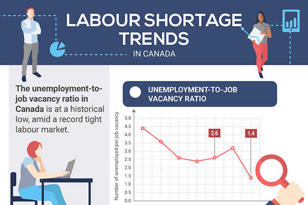
 Job vacancies, labour mobility and layoffs