
The Statistical Area Classification (SAC) by Province and Territory is a variant of the Standard Geographical Classification (SGC). Census subdivision (CSD) form the lowest level of this classification variant. This classification variant is based on the "Statistical Area Classification - Variant of SGC 2021", but with two additional levels in the hierarchy of the classification:
- Geographical regions of Canada
- Provinces and territories
This allows for the classification of the census metropolitan categories, the census metropolitan areas, census agglomerations and census metropolitan influenced zones, by provincial and territorial parts. The hierarchical structure of the classification is shown in Figure 3.
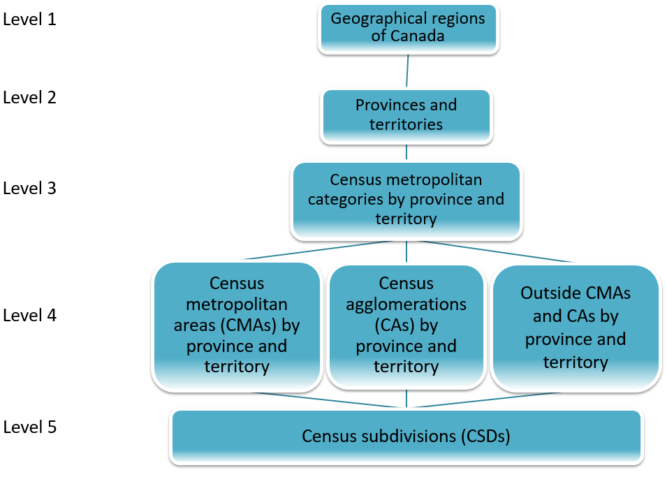
Description of Figure 3
- Level 1 - Geographical regions of Canada
- Level 2 - Provinces and territories
- Level 3 - Census metropolitan categories by province and territory
- Level 4 - Census metropolitan areas (CMAs) by province and territory, Census agglomerations (CAs) by province and territory, Outside CMAs and CAs by province and territory
- Level 5 - Census subdivisions (CSDs)
A provincial or territorial part designation is included with the name of the census metropolitan category by province and territory. For example, under the province of Manitoba, the three categories of this level are:
- Census metropolitan areas (Manitoba)
- Census agglomerations (Manitoba)
- Outside census metropolitan areas and census agglomerations (Manitoba)
Individual geographic units by province are presented for the census metropolitan areas (CMAs) and census agglomerations (CAs) by province. This is useful for the separate analysis of one CMA and three CAs that have provincial parts. The codes and names of the provincial parts of the CMAs and CAs are:
- 24 505 Ottawa–Gatineau (Quebec part)
- 35 505 Ottawa–Gatineau (Ontario part)
- 13 330 Campbellton (New Brunswick part)
- 24 330 Campbellton (Quebec part)
- 24 502 Hawkesbury (Quebec part)
- 35 502 Hawkesbury (Ontario part)
- 47 840 Lloydminster (Saskatchewan part)
- 48 840 Lloydminster (Alberta part)
The census metropolitan influenced zones by province and territory are also presented as provincial and territorial parts. For example, under the province of Quebec, the categories are:
- Strong metropolitan influenced zone (Quebec)
- Moderate metropolitan influenced zone (Quebec)
- Weak metropolitan influenced zone (Quebec)
- No metropolitan influenced zone (Quebec)