

Urban ecosystems are densely populated and intensively used areas. They comprise grey spaces (e.g., buildings, roads and parking lots), as well as green and blue spaces, such as parks, vegetable gardens, vegetation along roads, ponds and rivers. Green and blue spaces supply essential ecosystem services, such as water flow and local climate regulation as well as opportunities for outdoor recreation, which contribute to, among other things, promoting the health of residents and workers in cities.
Today, Statistics Canada is releasing an accounting framework to measure the extent, condition and ecosystem services of large urban ecosystems, as well as an initial dataset. These new products are part of Statistics Canada's Census of Environment program, which will cover all ecosystems in Canada.
The extent of large urban ecosystems increased from 2010 to 2020
In 2020, large urban ecosystems, represented by the 30 large contiguously settled areas (CSAs), covered more than 11,000 square kilometres in Canada, up about 2% from 2010. The large CSAs that saw the biggest increases in their extent over this decade were Milton (+13%), in Ontario; Saskatoon (+5%), in Saskatchewan; and London (+5%), in Ontario. In contrast, the extent of the CSAs of Nanaimo, in British Columbia; Halifax, in Nova Scotia; and Victoria, in British Columbia, grew less than 1%.
Moreover, the three CSAs with the largest extent in 2020 were among the top five CSAs with the highest population density in 2021: Toronto (2,878 persons per square kilometre), in Ontario; Montréal (2,866), in Quebec; and Vancouver (2,076), in British Columbia.
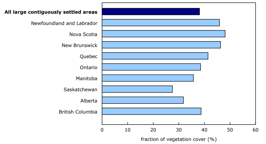
On average, vegetation covered a larger fraction of ground in the large urban ecosystems of the Atlantic provinces from 2019 to 2024
The fraction of ground covered with green vegetation influences the supply of ecosystem services in urban ecosystems. On average, from 2019 to 2024, large CSAs in the Atlantic region had the highest fraction of vegetation cover, at 47%, while CSAs in the drier region of the Prairies had 32% vegetation cover. On average, large CSAs in the regions of Quebec (41% vegetation cover), British Columbia (39%) and Ontario (38%) had fractions of vegetation cover between those observed in the Prairies and the Atlantic region.
Chart 1: Average vegetation cover, large contiguously settled areas, by province, 2019 to 2024
Description - Chart 1
Data table: Average vegetation cover, large contiguously settled areas, by province, 2019 to 2024
Notes: The values represent the average fraction of vegetation cover from 2019 to 2024. They refer only to the 30 large contiguously settled areas, which together covered an area of 11,323 square kilometres in 2020.
Source: Table 38-10-0187-01.
The fraction of vegetation cover varies within large urban ecosystems. From 2019 to 2024, the average fraction of vegetation cover in 23 of the 30 large CSAs was higher in their outskirts than in their centre. This difference was greatest in the CSAs of Saint-Jérôme, Quebec, where vegetation cover was 55% in the outskirts and 41% in the centre; Montréal, Quebec, where the difference was around 10 percentage points (46% in the outskirts versus 35% in the centre); and Ottawa–Gatineau (Quebec part), where the difference was 9 percentage points (51% in the outskirts compared with 42% in the centre).
The large urban ecosystems that had the least vegetation cover in their outskirts from 2019 to 2024 are among those whose extent grew the most from 2010 to 2020
On average from 2019 to 2024, the smallest fraction of vegetation cover on the outskirts of large CSAs in Canada was found in Regina, Saskatchewan (23%), Saskatoon, Saskatchewan (25%), Milton, Ontario (28%) and Calgary, Alberta (32%). These four CSAs are among the six that had the biggest growth rate from 2010 to 2020.
Table 1: Average vegetation cover, large contiguously settled areas, 2019 to 2024
Note to readers
Statistics Canada's Census of Environment program provides information on ecosystems in Canada to help Canadians make evidence-based decisions to protect, restore, enhance and preserve the environment. It follows the internationally accepted environmental-economic accounting standard for producing information on the extent, condition and services of ecosystems.
This release presents a framework to creating ecosystem accounts for large urban areas and includes estimates on their extent and vegetation cover. The new table (38-10-0187-01) shows the average fraction of vegetation cover for the 30 large contiguously settled areas (CSAs). In the coming years, the Census of Environment program will aim to improve these estimates and expand their scope and will also measure the services provided by urban ecosystems.
The fraction of vegetation cover (FVC), derived from Sentinel-2 satellite images, represents the fraction of ground covered by green vegetation, such as trees, shrubs or grass. The FVC is published by dissemination area (DA) for each of the 30 CSAs.
The CSAs developed by Statistics Canada represent the morphological footprint of settled areas. The outskirts of a large CSA comprise all DAs that overlap the CSAs boundary, including only the part of the DA located in the CSA. The rest of the CSA is considered to make up its centre.
For more information, consult the Canadian System of Environmental-Economic Accounting – Ecosystem Accounts (5331).
Reference
Data table: 38-10-0187-01.
- Note: some data tables may best be viewed on desktop.
Definitions, data sources and methods: survey number 5331.
Contact information
For more information, or to enquire about the concepts, methods or data quality of this release, contact us (toll-free 1-800-263-1136; 514-283-8300; infostats@statcan.gc.ca) or Media Relations (statcan.mediahotline-ligneinfomedias.statcan@statcan.gc.ca).