
Introduction
- Status
- What's new?
- Population Centre and Rural Area Classification 2016
- Background
- Conceptual framework and definitions
- Classification structure and codes
- Classification variant
Status
The Population Centre and Rural Area Classification 2016 is the current departmental standard and was approved on January 16, 2017.
What's new?
The Population Centre and Rural Area Classification is a new departmental standard.
Population Centre and Rural Area Classification 2016
The Population Centre and Rural Area Classification 2016 provides standard names and codes for Canada's population centres (POPCTRs) and rural area (RA). A classification variant provides the standard names and codes for POPCTRs and RA by province and territory.
Background
The Population Centre and Rural Area Classification has been developed to classify population centres and rural area.
The term 'urban' is widely used and one that people intuitively understand – a concentration of population at a high density. It is the opposite of 'rural', where population is not concentrated but dispersed at a low density. This intuitive perspective readily identifies the extremes of what is really a continuum. What is not so intuitive is how to segment the continuum.
Statistics Canada defined urban areas using the same methodology based on population size and density from the 1971 Census through to the 2006 Census. An 'urban area' was defined as having a population of at least 1,000 and a density of 400 or more people per square kilometre. All territory outside an urban area was defined as rural area. Together, urban areas and rural area covered the entire nation.
This methodology established a simple urban-rural dichotomy for Canada. However, the approach was not without some challenges. The term 'urban' is widely used and the interpretation of what is 'urban' often depends on points of view, interests and applications.
From the 1971 Census through the 2006 Census, all communities that met the minimum population concentration and density requirements of the definition were labelled as urban areas. They included small centres with a population of 1,000, up to those of more than one million. This approach ignored the differences among these urban areas by treating them as a single group. Given the widely accepted view that a more dynamic urban-rural continuum existed, the use of the term 'urban area' as it was then defined could have led to misinterpretations.
In addition, because of the broad interpretation of 'urban', Statistics Canada had not been using the term consistently when disseminating its data. In particular, the term 'urban' was sometimes used when referring to a census metropolitan area or a census agglomeration. Such areas are groupings of municipalities and typically included a combination of both urban areas and rural area.
In 2010, two changes were made to address these challenges. First, the term 'population centre' replaced the term 'urban area'. A population centre was defined as an area with a population of at least 1,000 and a density of 400 or more people per square kilometre. All areas outside population centres continued to be defined as rural area.
Secondly, population centres were divided into three groups based on the size of their population to reflect the existence of an urban-rural continuum:
- small population centres, with a population of between 1,000 and 29,999
- medium population centres, with a population of between 30,000 and 99,999
- large urban population centres, consisting of a population of 100,000 and over.
While other classifications were possible, the intent of this set was to provide users with a basic starting point to better understand the dynamic landscape of Canada.
Users of the former urban area concept are still able to continue with their longitudinal analysis using population centres.
These changes were meant to improve interpretation of Statistics Canada data and help users in the study of the Canadian urban-rural landscape and its issues.
In 2016, two new criteria were added to the delineation rules for population centres: the use of a secondary population density threshold as well as employment density.
Conceptual framework and definitions
The Population Centre and Rural Area Classification conforms to the basic principles of statistical classification. It consists of a set of discrete units that are mutually exclusive and, in total, cover the entire universe. Usually, a classification appears as a hierarchy, each level of which satisfies the above-mentioned principles and is defined by the uniform application of a single criterion. Applied to geography, these principles result in a classification consisting of geographic areas whose boundaries are specifically delimited in accordance with well-defined concepts and which, in total, cover the entire landmass of Canada.
The Population Centre and Rural Area Classification is one of a family of geographical classifications approved and used in Statistics Canada. These geographical classifications provide the basic definitions of geographic areas which, when adopted for data collection and dissemination, result in statistics that are comparable among data series and over time.
In the Population Centre and Rural Area Classification 2016, there are 30 large urban population centres, 57 medium population centres and 918 small population centres.
1. Population centres
A population centre (POPCTR) has a population of at least 1,000 and a population density of 400 persons or more per square kilometre, based on population counts from the current Census of Population. All areas outside population centres are classified as rural areas.
Taken together, population centres and rural areas cover all of Canada.
Population centres are classified into three groups, depending on the size of their population:
- small population centres, with a population between 1,000 and 29,999
- medium population centres, with a population between 30,000 and 99,999
- large urban population centres, with a population of 100,000 or more.
The population of the population centre includes all population living in the cores, secondary cores and fringes of census metropolitan areas (CMAs) and census agglomerations (CAs), as well as the population living in population centres outside CMAs and CAs.
As part of the 2016 Census, derivation of population centres used a revised set of criteria. 2016 Census dissemination blocks were used as building blocks for the delineation. In addition, new thresholds were added to the delineation steps.
The population density of 400 persons per square kilometre was retained as the primary density threshold and a secondary population density threshold of 200 persons per square kilometre was added. Employment density was also added to the delineation. Employment density was calculated for each dissemination block based on data obtained from Statistics Canada's Business Register and a threshold of 400 employees per square kilometre was chosen for the delineation.
The 2016 delineation rules for population centres are ranked in order of priority:
- If a dissemination block or group of contiguous dissemination blocks, each having a population density of at least 400 persons per square kilometre for the current census, then the dissemination block or group of contiguous dissemination blocks is delineated as a population cluster.
- If a dissemination block has a population density of at least 200 persons per kilometre or an employment density of 400 employees per square kilometre and it is adjacent to a population cluster, then it is added to that cluster.
- In order to be retained as a population centre, the resulting population cluster must have a minimum population of 1,000 and a population density of at least 400 persons per square kilometre.
- The distance by road between population centres is measured. If the distance is less than two kilometres, then the population centres are, in most cases, combined to form a single population centre. Certain restrictions apply when combining population centres located less than two kilometres apart. For example, population centres are only combined provided they do not cross census metropolitan area (CMA) or census agglomeration (CA) boundaries, or if the population centre, which is also a secondary core, is not combined with another core. In some instances, population centres are not combined because the current block structure does not always permit such a merger. For example, if the addition of intermediate blocks would cause the population density of the newly-formed population centre to drop below 400, then the blocks would not be added and the two near adjacent population centres would remain separated.
- Dissemination blocks that correspond to airport locations and are less than two kilometres away from the population centre are added to the population centre, provided they do not compromise the population density threshold of 400 persons per square kilometre.
- Interior holes are filled and irregularities to outer boundaries are smoothed.
The resulting population centres are reviewed and may be modified to ensure spatial contiguity and optimal boundaries.
2. Rural areas
Rural areas (RAs) include all territory lying outside population centres (POPCTRs). Taken together, population centres and rural areas cover all of Canada.
Rural population includes all population living in rural areas of census metropolitan areas (CMAs) and census agglomerations (CAs), as well as population living in rural areas outside CMAs and CAs.
Classification structure and codes
The Population Centre and Rural Area Classification has two levels. The relationship is illustrated in Figure 1.

Description of Figure 1
- Level 1
- Population centre size class categories and rural area
- Level 2
- Large urban population centres
- Medium population centres
- Small population centres
- Rural area.
Level 1: Population centre size class categories and rural area
The first level is made up of the four category names: large urban population centres, medium population centres, small population centres and rural area.
Level 2: Population centres and rural area
The second level is made up of the names and codes of population centres that fall within their specific size class category. All population centres are identified using four-digit codes.
Classification variant
In Statistics Canada, variants are created and adopted in cases where the version of the base classification does not fully meet specific user needs for disseminating data or for sampling in surveys. A classification variant is based on a classification version such as the Population Centre and Rural Area Classification 2016. In a variant, the categories of the base classification version are aggregated, regrouped or extended to provide additions or alternatives (e.g., context-specific additions) to the standard structure of the base version.
Variant: Population Centre and Rural Area 2016 by Province and Territory
The Population Centre and Rural Area 2016 by Province and Territory is a variant of the Population Centre and Rural Area Classification. This classification variant has two additional levels in the hierarchy of the classification:
- Geographical regions of Canada
- Provinces and territories
This allows for the classification of the population centre size class categories and rural area by provincial and territorial parts. The hierarchical structure of the classification is shown in Figure 2.
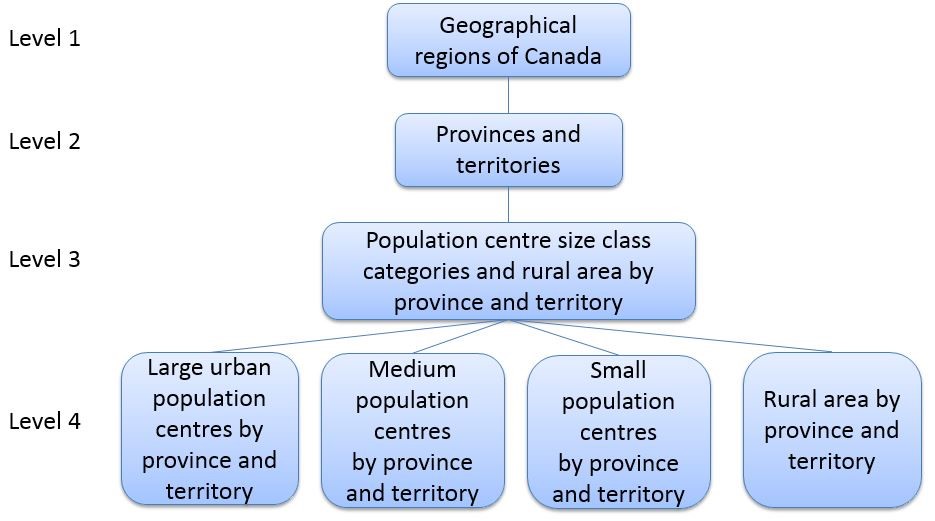
Description of Figure 2
- Level 1
- Geographical regions of Canada
- Level 2
- Provinces and territories
- Level 3
- Population centre size class categories and rural area by province and territory
- Level 4
- Large urban population centres by province and territory
- Medium population centres by province and territory
- Small population centres by province and territory
- Rural area by province and territory
Level 1: Geographical regions of Canada
The geographical regions of Canada are groupings of provinces and territories established for the purpose of statistical reporting. The six geographical regions of Canada are:
- Atlantic
- Quebec
- Ontario
- Prairies
- British Columbia
- Territories
Level 2: Provinces and territories
'Province' and 'territory' refer to the major political units of Canada. From a statistical point of view, province and territory are basic areas for which data are tabulated. Canada is divided into 10 provinces and 3 territories.
Level 3: Population centre size class categories and rural area by province and territory
This level is made up of the four category names (large urban population centres, medium population centres, small population centres and rural area), by province and territory.
A provincial or territorial part designation is included with the name of the population centre size class category and rural area by province and territory. For example, under the province of Alberta, the four categories of this level are:
- Large urban population centres (Alberta)
- Medium population centres (Alberta)
- Small population centres (Alberta)
- Rural area (Alberta)
Level 4: Population centres and rural area by province and territory
This level is made up of the names and codes of population centres that fall within their specific size class category, by province and territory. All population centres in this variant are identified with a six-digit code: the two-digit province/territory code followed by the four-digit population centre code.
There are five cases where the population centres cross provincial boundaries in the base classification. In the variant, the provincial parts are presented for each of the population centres. This is useful for the separate analysis of these population centres that have provincial parts. The codes and names of the provincial parts of these population centres are:
- 13 0122 Campbellton (New Brunswick part)
- 24 0122 Campbellton (Quebec part)
- 24 0365 Hawkesbury (Quebec part)
- 35 0365 Hawkesbury (Ontario part)
- 24 0616 Ottawa–Gatineau (Quebec part)
- 35 0616 Ottawa–Gatineau (Ontario part)
- 46 0282 Flin Flon (Manitoba part)
- 47 0282 Flin Flon (Saskatchewan part)
- 47 0478 Lloydminster (Saskatchewan part)
- 48 0478 Lloydminster (Alberta part)