Study: Urban greenness
Archived Content
Information identified as archived is provided for reference, research or recordkeeping purposes. It is not subject to the Government of Canada Web Standards and has not been altered or updated since it was archived. Please "contact us" to request a format other than those available.
Released: 2021-08-17
Canadian cities consistently rank among the most livable in the world. The quality of the urban environment, including parks and green space and the overall level of greenness, plays an important role in promoting well-being. Trees and vegetation can improve urban air quality, moderate urban heat island effects, reduce or delay storm water runoff, provide wildlife habitat and provide recreational opportunities and beauty. Urban greenness reflects the presence and health of vegetation in urban areas and is a measure of the condition of an urban ecosystem.
The majority (76%) of the total land area in 996 cities, suburbs and towns across Canada was classed as green in 2019. However, a new study shows that the overall share of urban area that was predominantly green had dropped compared with 2001. The change can be attributed to factors such as urban growth, climate conditions and insect infestations.
The study "Urban greenness, 2001, 2011 and 2019" uses satellite imagery to track greenness in population centres for three time periods (2001, 2011 and 2019). The data reflect the presence and health of vegetation during peak summer conditions across the entire city, including publicly and privately owned green space and features (see Note to readers).
More than two-thirds of Canada's large population centres were classified as green in 2019
Canada's population grew by just over five million people from 2001 to 2016, with most of that growth occurring in larger cities.
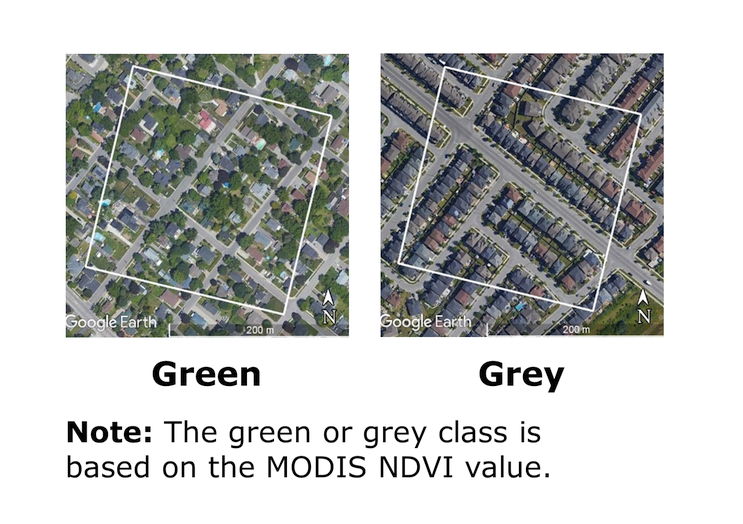
More people means more homes, and urban densification and expansion can reduce the quantity and quality of "green" areas and increase the "grey" areas that consist of buildings, impervious surfaces, bare soil and low density vegetation.
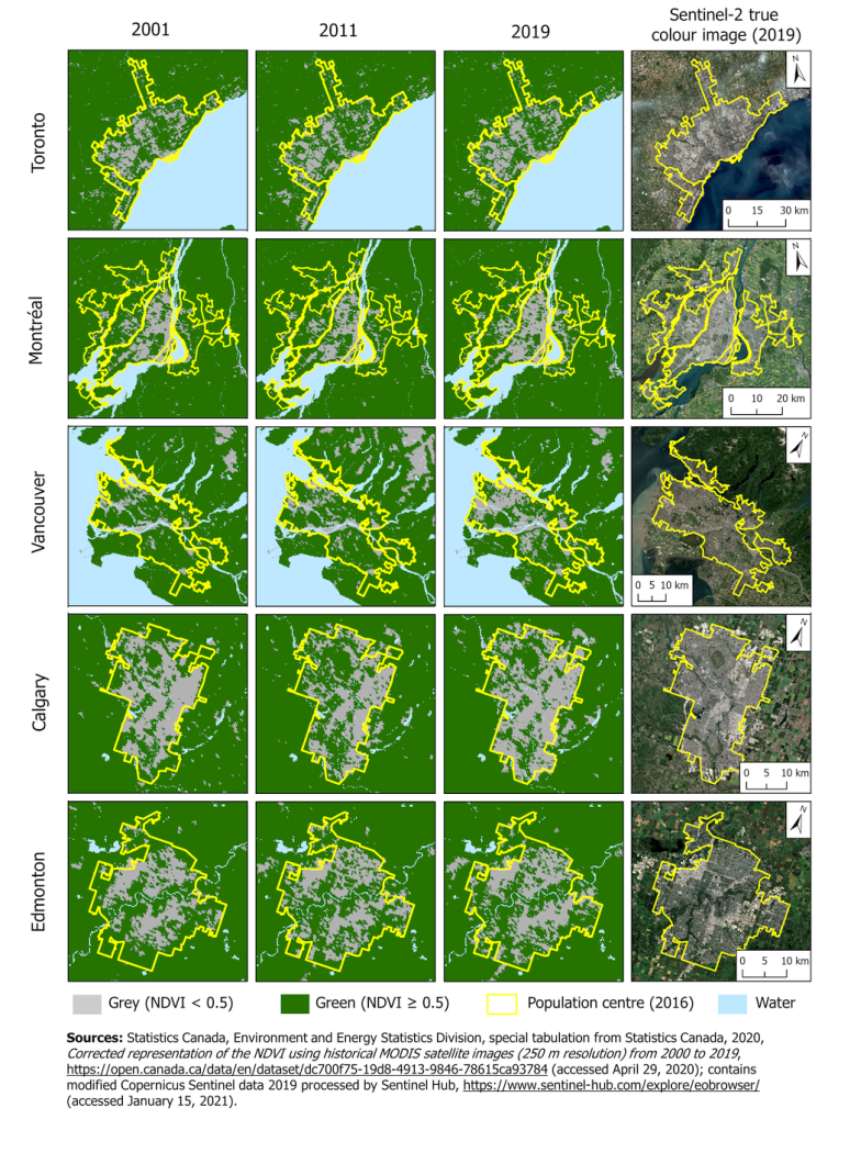
Nevertheless, 70% of the total land area in Canada's large urban population centres (100,000 or more people) was classified as green in 2019. Montréal (70%) and Vancouver (68%) were the greenest among Canada's five largest urban centres, followed by Toronto (65%), Edmonton (60%) and Calgary (42%).
Kanata (94%), in the west end of Ottawa, was classified as Canada's greenest large urban population centre in 2019, while Winnipeg was the least green (38%). Regional differences in climate, pests and vegetation will influence this score. For example, Winnipeg was affected by the emerald ash borer, an invasive species insect that has decimated ash trees in the city, as well as drought conditions in 2019.
Medium (78%) and small (87%) population centres were on average greener than large urban areas. In fact, more than one-third (35%) of all small population centres in Canada were deemed entirely green.
Urban growth, drought and invasive species all contribute to the drop in urban greenness
Overall, the share of green area in Canada's urban centres was lower in 2019 compared with the turn of the century. In fact, about three-quarters of large (77%) and medium (71%) population centres had lower levels of greenness in 2019 relative to 2001. Small population centres saw less change—greenness was stable in one-third (33%) of small population centres.
Between 2001 and 2011, the overall proportion of urban greenness remained the same. This finding is largely explained by the widespread impact of the 2001 drought across southwest Canada and near-drought in Ontario and Quebec, which had a significant impact on the condition of urban forests, resulting in a lower proportion of green area that year.
In contrast, weather conditions during the 2011 growing season were closer to the historical average, and close to half of large (55%) and medium (41%) population centres reported an increase in greenness. However, greenness decreased in about one-third (29%) of large centres and in close to half (47%) of medium population centres from 2001 to 2011, suggesting that urban growth likely played a role in the drop. In 2011, urban greenness was stable or increased in the majority (74%) of small population centres relative to 2001.
Largest decreases in urban greenness are in British Columbia and the Prairies
The largest decreases in greenness from 2001 to 2019 occurred in Winnipeg, Milton, Kelowna, Windsor and Vancouver. These larger decreases in greenness were likely driven partly by the contributions of urbanization, as well as moderate drought conditions in 2019, while trees in Winnipeg and Windsor also experienced insect damage and mortality.
In Milton, the drop in green area coincided with a population increase of 350% from 2001 to 2016.
Note to readers
This release provides an overview of urban greenness in Canada for three reference years over an 18-year period (2001, 2011 and 2019) as a measure of urban condition. This new assessment provides a consistent approach for measuring urban greenness across the country, which can be used to help measure progress towards United Nations Sustainable Development Goal 11, target 11.7.
Population centres have a population of at least 1,000 and a population density of 400 persons or more per square kilometre, based on population counts from the Census of Population. All areas outside population centres are classified as rural areas. Population centres are classified in three groups: small (population between 1,000 and 29,999), medium (population between 30,000 and 99,999) and large urban (100,000 or more).
Greenness was assessed for the reference years using the Normalized Difference Vegetation Index (NDVI) from Moderate Resolution Imaging Spectroradiometer (MODIS) data for the same physical area using the 2016 population centre boundary to ensure consistency. The urban "green" class defined in this analysis corresponds to areas with an NDVI of 0.5 or more, while areas with lower values were classed as "grey."
Products
The study "Urban greenness, 2001, 2011 and 2019" is now available in EnviroStats (Catalogue number 16-002-X).
A data table, "Urban greenness by population centre, 2001 to 2019," is also available upon request.
Contact information
For more information, or to enquire about the concepts, methods or data quality of this release, contact us (toll-free 1-800-263-1136; 514-283-8300; STATCAN.infostats-infostats.STATCAN@canada.ca) or Media Relations (613-951-4636; STATCAN.mediahotline-ligneinfomedias.STATCAN@canada.ca).
- Date modified:


